How Space Technology Is Helping India's Smallholder Farmers
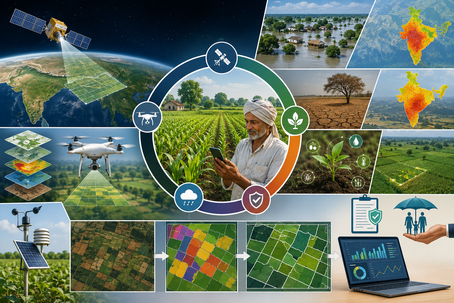




When we think about India's agricultural strength, we often imagine vast green fields stretching across the countryside, feeding more than a billion people and contributing significantly to the nation's economy. Yet, hidden within this landscape is a challenge that receives far less attention: most Indian farmers cultivate very small and fragmented pieces of land.
Today, majority of India's farmers belong to the small and marginal category. Their fields are often divided into multiple tiny plots scattered across villages and landscapes. While these farmers form the backbone of India's food system, their fragmented landholdings make it difficult to monitor crop health, assess risks, provide insurance support, and implement modern agricultural technologies. In many cases, these small plots are so tiny that they become nearly invisible in conventional agricultural databases and monitoring systems.
This realization became the starting point of our research.
As researchers working at the intersection of disaster management, geospatial science, and agricultural sustainability, we repeatedly encountered a fundamental question: How can we protect farmers from climate risks if we cannot accurately identify and monitor the fields they cultivate?
The challenge is particularly important in a country like India, where agriculture remains highly vulnerable to floods, droughts, heat waves, pest outbreaks, and changing rainfall patterns. Climate change is increasing the frequency and intensity of these hazards, placing unprecedented pressure on farming communities. Smallholder farmers are often the first to experience these impacts and the last to receive timely support.
At the same time, we are living in an era where satellites orbit the Earth every day, drones can capture centimetre-level imagery, and artificial intelligence can analyze millions of data points within seconds. The question was no longer whether technology exists, but whether it can be effectively used to serve India's fragmented agricultural landscape.
This motivation led us to undertake a comprehensive review of Earth Observation (EO) technologies for agricultural risk management in India's small and fragmented croplands.
Earth Observation refers to the use of satellites, drones, aircraft, and ground-based sensors to collect information about the Earth's surface. Every day, these technologies capture enormous amounts of data about vegetation, soil moisture, crop conditions, water availability, and environmental changes. However, the challenge lies in translating this information into practical solutions for small farmers.
During our investigation, we examined decades of scientific research from India and across the world. We explored how different sensing platforms—from satellites such as Landsat and Sentinel, SAR, to advanced drones and hyperspectral sensors—can help identify individual agricultural plots, monitor crop conditions, and assess risks.
One of the most fascinating discoveries was how plants communicate their health status through light.
Healthy crops reflect and absorb sunlight differently than stressed crops. Sensors mounted on satellites can detect these subtle differences in reflected light, often long before visible symptoms appear to the human eye. By analyzing specific wavelengths, scientists can estimate crop health, water stress, nutrient conditions, and even predict yields.
For smallholder farmers, this capability has enormous implications.
Imagine a farmer receiving an early warning that a section of their field is experiencing water stress. Imagine crop insurance companies being able to verify disaster-related crop damage within days instead of months. Imagine government agencies identifying drought-affected villages in near real time and delivering assistance before losses become catastrophic.
These possibilities are no longer science fiction. Many of the technologies already exist.
However, our review also revealed important challenges.
India's agricultural landscape is incredibly diverse. A field in Punjab looks very different from a terraced farm in Uttarakhand, a shifting cultivation plot in Northeast India, or a rain-fed farm in the Deccan Plateau. Small fields often have irregular shapes, mixed cropping patterns, and poorly defined boundaries. Traditional satellite imagery sometimes struggles to distinguish these tiny plots accurately.
Fortunately, recent advances in artificial intelligence are changing the situation dramatically.
Modern machine learning and deep learning techniques can now analyze satellite images with unprecedented accuracy. Technologies such as object-based image analysis, convolutional neural networks, and emerging GeoAI frameworks can automatically detect field boundaries, classify crops, and monitor agricultural conditions over large areas. These tools are helping researchers move from simply observing agricultural landscapes to understanding them in detail.
Another important insight from our work is that no single technology can solve the problem alone.
Satellites provide broad coverage over entire regions. Drones deliver extremely detailed local information. Radar sensors can see through clouds during the monsoon season. Ground-based observations provide valuable validation. The future lies in combining these multiple sources of information into integrated systems that offer both accuracy and scalability.
Beyond agricultural productivity, this work has broader implications for disaster risk reduction and national resilience.
Accurate mapping of small landholdings can improve flood exposure assessments, drought monitoring, crop insurance implementation, food security planning, and climate adaptation strategies. In regions such as the Ganga-Brahmaputra-Meghna basin, where farmers face recurring floods, erosion, and climate variability, detailed geospatial information can support more effective risk management and evidence-based decision-making.
Ultimately, this paper is about visibility.
For decades, millions of smallholder farmers have contributed immensely to India's food security while remaining under-represented in technological systems and policy frameworks. Earth Observation technologies offer an opportunity to change that reality.
By making small farms visible, we can make them measurable. By making them measurable, we can manage risks more effectively. And by managing risks more effectively, we can build a more resilient agricultural future.
The story behind this research is therefore not merely about satellites, sensors, or algorithms. It is about ensuring that the farmer cultivating a one-acre plot receives the same technological attention as large agricultural enterprises. It is about using science to bridge the gap between innovation and inclusion.
As climate risks continue to grow, the ability to see every field—and every farmer—may become one of the most important tools for securing India's agricultural future.

Follow the Topic
-
Discover Applied Sciences
This is a multi-disciplinary, peer-reviewed journal for the disciplines of Applied Life Sciences, Chemistry, Earth and Environmental Sciences, Engineering, Materials Science and Physics, fostering sound scientific discovery to solve practical problems.

Related Collections
With Collections, you can get published faster and increase your visibility.
Engineering: Technological Advancement in Wireless Sensor Networks and Its Scope in Industry 4.0 IoT
This Topical Collection is dedicated to highlighting the cutting-edge methods and latest research in the field of smart sensing, primarily in terms of exploring the latest machine learning analytics to extract information from the consequent sensory data, and investigating potential risk and countermeasures to ensure the security and privacy of sensing devices in WSN based Internet of Things/ Industrial Internet of things (IoT/IIoT). It allows researchers in WSN and IoT community to demonstrate their new ideas which may potentially reshape the future of IoT/IIoT. While sensing data have been traditionally processed within a powerful remote cloud server, the recent emergence of edge computing with these communication technologies makes it feasible to perform AI processing at the edges. Edge processing is aimed at overcoming the slower and more expensive method of sending the data to the cloud. The benefits of the parallel development of cloud-edge technologies in wireless sensor networks and communications are manifold. The progress in the development of these technologies has opened several new opportunities in multi-domain applications, such as smart cities, transportation, intelligent manufacturing, and e-Health.
Publishing Model: Open Access
Deadline: Sep 30, 2026
Earth and Environmental Sciences: Crop Diversification for Resilient Ecosystem
Crop diversification is a strategic approach in agriculture that involves cultivating a range of different crops on a farm rather than relying solely on one type of crop. This practice offers numerous advantages, including reducing the risk of crop failure due to pests, diseases, or adverse weather conditions. By growing a variety of crops, farmers can also maintain soil health and fertility more effectively, as different crops have varying nutrient requirements and growth patterns. Moreover, crop diversification provides farmers with opportunities to tap into diverse markets, stabilize their income throughout the year, and contribute to environmental sustainability by promoting biodiversity and reducing reliance on chemical inputs. Overall, crop diversification is a key aspect of modern farming practices aimed at enhancing resilience, profitability, and ecological stewardship. Along with this, a resilient ecosystem is one that demonstrates the capacity to withstand and recover from disturbances while maintaining its essential functions and supporting biodiversity. These ecosystems possess several key characteristics that contribute to their resilience. Firstly, they have high levels of biodiversity, including a variety of species with different functions and niches. This diversity helps buffer against environmental changes and increases the likelihood that some species will thrive even under adverse conditions. Additionally, resilient ecosystems often exhibit strong ecological connectivity, allowing for the movement of species and genetic material across landscapes, which promotes adaptation and enhances overall resilience. They also tend to have robust feedback mechanisms and adaptive management strategies in place, enabling them to respond flexibly to disturbances and incorporate new information into their resilience strategies. Overall, resilient ecosystems play a crucial role in sustaining life on Earth by providing essential services such as clean air and water, climate regulation, and habitat for wildlife, while also supporting human well-being and livelihoods.
In this Topical Collection, we invite novel research and constrictive review works that share new insight results on the subject, as well as establish a positive discussion about the Crop Diversification for Resilient Ecosystem.
Major themes include:
- Ecosystem services for soil health management
- Biodiversity conservation for ecosystem resilience
- Sustainable soil health management through crop diversification
- Climate resilience farming for ecosystem management
- Reduced pesticide dependency through crop management
- Water quality management for enhancing nutrient use efficiency
- Crops nutritional dietary diversity
- Food security through crop management
- Economic stability through crop management
- Ecosystem services and crop risk management
- Crop diversification through building resilient ecosystems
- Water management through crop diversification
- Sustainable agriculture through
- Cultural Heritage and crops diversification
This Collection supports and amplifies research related to: SDG 2, SDG 15
Publishing Model: Open Access
Deadline: Dec 31, 2026

Please sign in or register for FREE
If you are a registered user on Research Communities by Springer Nature, please sign in