Spatially Dependent Extreme Precipitation and Its Engineering Implications

Regional frequency analysis improves rainfall frequency estimates by pooling exceedances from multiple gauges. However, a single storm can produce extremes at several stations, creating spatially dependent exceedances that violate independence assumptions and bias depth-duration-frequency values.

Published in Statistics

Share this post

Choose a social network to share with, or copy the URL to share elsewhere

This is a representation of how your post may appear on social media. The actual post will vary between social networks

Explore the Research

Springer Berlin Heidelberg
Springer Berlin Heidelberg Springer Berlin Heidelberg

A simple method for enhancing the spatial independence of regional partial duration series in extreme, short-duration rainfall frequency analyses

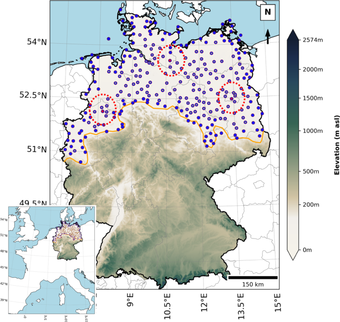
Regional frequency analyses (RFA) using partial duration series (PDSs) generally produce more reliable rainfall depth-duration-frequency (DDF) estimates than those based on annual maxima. A common implementation of this approach, the station-year method, pools threshold exceedances across multiple sites within a region to construct a regional PDS (rPDS). However, there may be instances in which a specific rainstorm evolving over the region produces multiple exceedances (at different rain gauges) that happen to be selected in the rPDS; the resulting spatial dependence violates the independence assumption fundamental to frequency analysis. Furthermore, the nature and consequences of this spatial dependence on DDFs across the range of average recurrence intervals (ARIs) remain poorly understood. We address this gap with two contributions. First, we propose a dual-criterion filtering algorithm based on a highly simplified description of the motion of a rainstorm, to ensure that most events included in a rPDS are spatially independent. Second, we develop a mathematical framework to characterize how spatial dependence biases DDF values. Manual verification using radar-derived spatiotemporal footprints of storms show that the algorithm identifies and removes spatially dependent exceedances with above 90% accuracy. Theoretical analyses further establish its statistical consistency and engineering relevance. Results from 137 German stations reveal that the conventional station-year method systematically overestimates DDF values at low ARIs and underestimates them at high ARIs. This bias stems entirely from the inclusion of spatially dependent exceedances in the rPDS. Using the proposed filtering algorithm increases the accuracy of DDF estimates by enhancing the independence of the exceedances used for frequency analysis.

In a recent study published in Stochastic Environmental Research and Risk Assessment, we developed a simple filtering framework that uses storm motion and station proximity to identify and remove spatially dependent exceedances from regional partial duration series. The method was evaluated using high-resolution rain-gauge and weather-radar observations from northern Germany, where manual verification showed that the framework correctly identified spatially dependent exceedances in more than 90% of cases. 

Our results show that spatial dependence systematically alters the shape of regional exceedance distributions. The conventional station-year approach tends to overrepresent moderate rainfall exceedances generated by the same storm, leading to overestimation of frequent-event rainfall and underestimation of rare-event rainfall. Across the analyzed short durations, this effect translated into average overestimations of approximately 14% for 1-year events and underestimations of about 5% for 100-year events. These biases can lead to unnecessarily conservative designs for low-risk infrastructure while simultaneously underestimating design rainfall for infrastructure intended to withstand rare, high-impact events. By improving the spatial independence of regional partial duration series, the proposed framework provides more reliable rainfall frequency estimates for hydrologic design, flood-risk assessment, and infrastructure resilience planning.