e-ITALICA: a new catalogue for landslide forecasting in Italy
Published in Earth & Environment and Research Data
Explore the Research
An enhanced rainfall-induced landslide catalogue in Italy - Scientific Data
Scientific Data - An enhanced rainfall-induced landslide catalogue in Italy
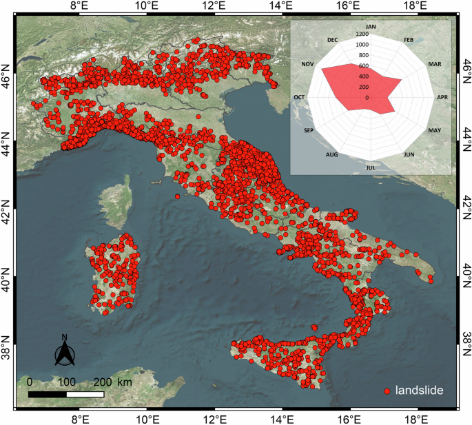
Landslides pose a significant risk to Italy, with significant impacts on both the population and the environment. Accurate prediction of these phenomena is crucial for effective risk mitigation. In this context, the availability of accurate and comprehensive data on past landslides and the rainfall conditions that triggered them is fundamental. A recent study published by a team of researchers at the Research Institute for Geo-Hydrological Protection of the Italian National Research Council in Perugia has led to the development of e-ITALICA, an enhanced version of ITALICA (the ITAlian rainfall-induced LandslIdes Catalogue). This new version promises to significantly improve our ability to predict and manage landslide risk.
Why a new landslide catalogue?
Landslide research, especially over large areas, often relies on statistical models and machine learning techniques that require high-quality data to be effective. While the previous ITALICA catalogue already represented a significant step forward, providing detailed spatial and temporal information on the occurrence of landslides throughout the Italian territory, e-ITALICA adds a crucial enhancement: the inclusion of the rainfall conditions responsible for the listed failures. The accurate reconstruction of these conditions is essential for developing reliable predictive models. In addition, land cover data were added by overlaying Corine Land Cover maps from 2006, 2012 and 2018 with the spatial and temporal coordinates of the landslides. The average slope and elevation for each landslide were estimated using slope units.
e-ITALICA is the result of meticulous data collection and analysis. Landslide information has been gathered from various sources, with particular attention paid to spatial and temporal accuracy. For rainfall data, an automatic algorithm called CTRL-T was used to identify the representative rain gauges and to quantify the rainfall events responsible for the landslide initiation. This tool enabled the analysis of rainfall time series and the reconstruction of the duration and amount of rainfall that presumably triggered each landslide.
What does e-ITALICA contain?
e-ITALICA is a comprehensive and detailed catalogue that collects information on 6312 rainfall-induced landslides that occurred in Italy between 1996 and 2021. Overall, more than one-third of the catalogue has very high geographic accuracy (< 1 km2) and hourly temporal resolution, making e-ITALICA the largest catalogue of rainfall-induced landslides accurately located in space and time available in Italy. Compared to the previous catalogue, e-ITALICA includes the rainfall conditions that triggered each landslide, specifically the duration (D) in hours and the amount of cumulative rainfall (E) in millimeters. These data have been obtained through a rigorous and reproducible analysis of hourly measurements from 4033 rain gauges distributed throughout Italy. In addition to rainfall data, e-ITALICA also provides the following information for each landslide: (i) source of information; (ii) landslide type (if available from the source); (iii) landslide location (coordinates, municipality, province, region, geographic accuracy); (iv) temporal information (day, month, year, time, date, temporal accuracy); (v) topographic information (elevation and slope) and (vi) land cover information.
A safer future with e-ITALICA
e-ITALICA marks a significant step forward in landslide prediction in Italy. The public availability of this dataset promotes data sharing and collaboration among researchers and institutions, key elements in successfully addressing the challenges of landslide risk. The catalogue allows the analysis of rainfall conditions capable of triggering landslides in different areas of Italy. By combining rainfall data with topographic and land cover information, it is possible to study the relationship between these variables and the probability of landslide occurrence, opening up new research perspectives/opportunities. Thanks to its completeness, accuracy and rigorous methodological approach, e-ITALICA serves as a fundamental tool for scientific research, land management and civil protection. In fact, e-ITALICA can be used to define, calibrate, and validate both statistical and physical landslide predictive models, improving their accuracy and reliability. e-ITALICA allows the definition of empirical rainfall thresholds at both local and national scales, which can be integrated into more effective landslide early warning systems. By improving landslide forecasting and risk mitigation strategies, e-ITALICA contributes to a safer Italian territory.
Follow the Topic
-
Scientific Data
A peer-reviewed, open-access journal for descriptions of datasets, and research that advances the sharing and reuse of scientific data.

Related Collections
With Collections, you can get published faster and increase your visibility.
Genomics in freshwater and marine science
Publishing Model: Open Access
Deadline: Jul 23, 2026
Genomes of endangered species
Publishing Model: Open Access
Deadline: Jul 01, 2026

Please sign in or register for FREE
If you are a registered user on Research Communities by Springer Nature, please sign in