How Efficient Is Tehran’s Transport Network? A Route Factor Perspective on Accessibility, Urban Form, and Comparisons with European Cities and Greater London
Published in Sustainability, Civil Engineering, and Statistics

🚦 Why do some journeys feel much longer than they should?
This simple question motivated our research on transport accessibility in Tehran, one of the largest and fastest-growing metropolitan areas in the Middle East.
When discussing urban mobility, planners often focus on congestion, travel time, or public transport coverage. However, another important indicator receives far less attention: Route Factor, sometimes called circuity or the detour index. Route Factor measures how much longer a real trip on a transport network is compared with the ideal straight-line distance between two locations.
A Route Factor of 1.0 would represent a perfectly direct connection. Higher values indicate that travellers must take increasingly indirect routes because of street layouts, barriers, topography, land-use patterns, or network design.
🏙️ Exploring accessibility across Tehran
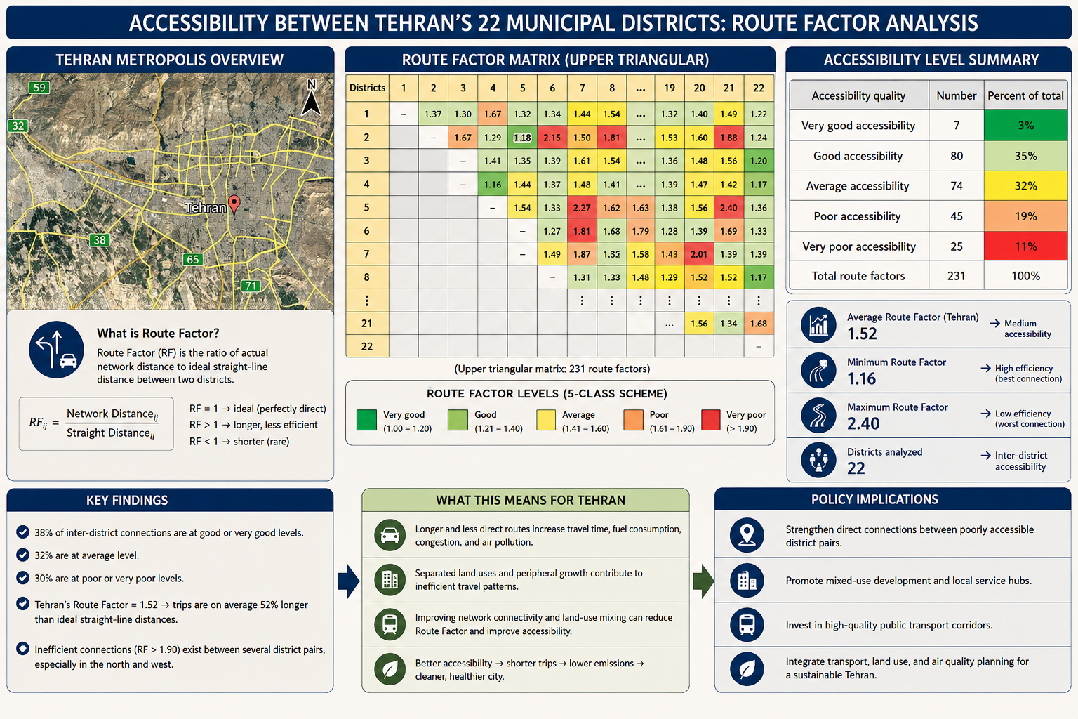
In our 2022 study, we applied Route Factor analysis to travel connections between Tehran’s 22 municipal districts. The goal was to better understand how efficiently the city's transport network connects people, jobs, services, and opportunities.
The results revealed an average Route Factor of 1.52. In practical terms, journeys between districts are approximately 52% longer than the direct distance separating them.
Accessibility conditions were far from uniform. Around 38% of inter-district connections showed good or very good accessibility, while 32% fell into the average category. The remaining 30% were classified as poor or very poor, indicating substantial inefficiencies in several parts of the city.
The findings suggest that while Tehran's network cannot be considered critically inefficient, significant opportunities exist for improving connectivity and reducing unnecessary travel distances.
🌍 How does Tehran compare internationally?
Route Factor analysis has been applied in many cities around the world under different names, including circuity, network directness, and detour index.
Studies of approximately 300 European cities report average road circuity values close to 1.34. Research on Greater London and surrounding metropolitan areas has found values ranging roughly from 1.39 to 2.09 depending on the scale and location examined.
Against this international backdrop, Tehran's average value of 1.52 places the city within the range observed in many large metropolitan regions. However, the comparison also highlights room for improvement, particularly given Tehran's environmental and mobility challenges.
🔎 The issue is bigger than roads
One of the most important lessons from this research is that transport efficiency cannot be explained solely by street geometry.
Several factors interact to increase travel distances across Tehran:
• Low-density peripheral development
• Weak land-use integration
• Spatial separation between housing, employment, education, and services
• Mountainous terrain and physical barriers
• Heavy dependence on private automobiles
When destinations are dispersed and urban functions become separated, residents are forced to travel farther for work, education, healthcare, shopping, and recreation. Longer trips contribute to higher fuel consumption, increased congestion, greater greenhouse-gas emissions, and worsening air quality.
🎯 From transport metric to planning tool
Route Factor should therefore be viewed as more than a transportation indicator.
It can help planners identify locations where investments in public transport may generate the greatest benefits, where local service hubs could reduce travel demand, and where land-use reforms might improve accessibility and urban equity.
For rapidly growing megacities, accessibility indicators such as Route Factor can provide valuable evidence for designing more connected, sustainable, and resilient urban environments.
💬 Looking ahead
As cities continue to expand, improving accessibility may be just as important as building new infrastructure.
Can Route Factor analysis help cities identify hidden inefficiencies in their transport networks and support cleaner, fairer, and more accessible urban futures?
I would be delighted to hear from researchers and practitioners working in GIS, accessibility analysis, transport planning, urban form, land-use planning, sustainability, and environmental management.
Head of Public Transportation, Tehran Municipality District 22 | Transportation Planning Specialist | 15+ years municipal experience | Sustainability & Climate Researcher: sustainable cities, GIS/Remote Sensing, air quality, methane monitoring & net-zero transition | ✍️ 9 research publications (incl. 5 Q1/Q2), 43 citations & 11 journal reviews | 🖨️ Recent research: Australia methane, Tehran spatial equity & Canada air pollution | 🤝 Collaborations with a Top 2% global scientist and an Australian Principal Scientist | 🎯 Translating research into climate policy & sustainable mobility.
Follow the Topic
What are SDG Topics?
An introduction to Sustainable Development Goals (SDGs) Topics and their role in highlighting sustainable development research.
Continue reading announcement


Please sign in or register for FREE
If you are a registered user on Research Communities by Springer Nature, please sign in