Satellite‑Based Methane Monitoring Across British Columbia, Alberta, Saskatchewan, and Manitoba: Identifying Climate Hotspots for Net‑Zero Action
Published in Earth & Environment

🌎 Can satellites help accelerate climate action in energy-producing regions?
Methane (CH₄) is one of the most important greenhouse gases contributing to near-term climate warming. Although it remains in the atmosphere for a shorter period than carbon dioxide, its warming potential is substantially greater over the first decades after emission.
Canada has committed to ambitious net-zero targets, yet effective methane mitigation depends on identifying where elevated atmospheric concentrations persist over time.
Western Canada—including British Columbia, Alberta, Saskatchewan, and Manitoba—is home to extensive oil and gas production, agriculture, wetlands, forests, and rapidly changing natural landscapes, making it an ideal region for investigating methane dynamics.
🛰️ Monitoring methane from space
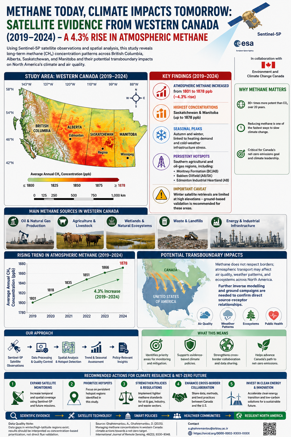
In our study, we developed a transparent satellite-based framework using Sentinel-5P observations to investigate atmospheric methane concentrations across Western Canada between 2019 and 2024.
Rather than measuring emissions directly, the study examines atmospheric methane concentrations and their spatial and temporal variability using Earth observation, Jenks natural breaks classification for hotspot identification, and bootstrapped resampling to provide transparent variability envelopes—ensuring the trends are reproducible and statistically robust.
This approach enables consistent regional monitoring across multiple provinces using freely available satellite observations.
📊 What did we discover?
Several important patterns emerged.
Several important patterns emerged. Atmospheric methane concentrations increased by approximately 4.3% (from 1801 to 1878 ppb) across Western Canada between 2019 and 2024. Persistent methane-enhancement zones were identified particularly in Saskatchewan and Manitoba, with notable seasonal peaks during autumn and winter—likely linked to heating demand and cold-weather infrastructure stress.
Persistent methane-enhancement zones were identified particularly in Saskatchewan and Manitoba, while Alberta also exhibited elevated concentrations in several years.
Spatial hotspot analysis revealed statistically significant clusters that remained relatively stable over time, suggesting priority areas for continued environmental monitoring.
Trend analysis further demonstrated that methane concentrations generally increased throughout the observation period, although the magnitude varied among provinces.
Importantly, these atmospheric hotspots should not be interpreted as direct evidence of individual emission sources, but rather as regions deserving additional investigation using complementary monitoring approaches.
🌱 Why does regional methane monitoring matter?
Satellite observations provide a unique opportunity to evaluate environmental conditions consistently across large geographic regions.
Such information can support:
• Methane monitoring strategies
• Regional climate policy
• Environmental reporting
• Priority-area screening
• Resource allocation
• Evidence-based mitigation planning
Large-scale satellite assessments complement existing ground observations by revealing spatial patterns that may otherwise remain unnoticed.
🇨🇦 Supporting Canada's Net-Zero Transition
Reducing methane emissions is widely recognised as one of the fastest opportunities to slow near-term climate change. With Canada committed to a 75% methane reduction target by 2030, our framework provides policy-relevant evidence to prioritise monitoring efforts and bridge the gap between satellite data and on-the-ground climate action.
By identifying persistent atmospheric methane hotspots, our framework provides information that can help governments prioritise monitoring efforts, improve environmental management, and strengthen climate mitigation strategies.
The proposed methodology is transparent, reproducible, and transferable to other regions facing similar environmental challenges.
🌍 Beyond Western Canada
Although this study focuses on Western Canada, the analytical framework can easily be adapted to other countries and regions.
Combining Sentinel-5P observations with spatial statistics provides an efficient and cost-effective approach for monitoring atmospheric methane over large areas where traditional monitoring networks are sparse.
As satellite technologies continue to improve, Earth observation will play an increasingly important role in supporting sustainable environmental governance.
💬 Looking ahead
Can satellite observations help transform environmental monitoring into practical climate action?
I welcome discussion and collaboration with researchers and policymakers—particularly on how to address winter data gaps in high-latitude satellite retrievals and how to combine Sentinel-5P with ground-based campaigns for better source attribution. What has been your experience with satellite methane monitoring in cold climates?
Link of the paper: https://www.tandfonline.com/doi/abs/10.1080/01431161.2025.2580780
Head of Public Transportation, Tehran Municipality District 22 | Transportation Planning Specialist | 15+ years municipal experience | Sustainability & Climate Researcher: sustainable cities, GIS/Remote Sensing, air quality, methane monitoring & net-zero transition | ✍️ 9 research publications (incl. 5 Q1/Q2), 43 citations & 11 journal reviews | 🖨️ Recent research: Australia methane, Tehran spatial equity & Canada air pollution | 🤝 Collaborations with a Top 2% global scientist and an Australian Principal Scientist | 🎯 Translating research into climate policy & sustainable mobility.