Can Tehran Become a 15-Minute City? Revealing Hidden Urban Sprawl Through Satellite and Municipal Data: Lessons from Melbourne (Australia), Barcelon (Spain), and Paris (France)
Published in Earth & Environment, Sustainability, and Statistics
🏙️ Can a rapidly growing megacity become a 15-minute city?
This question has become increasingly important as cities around the world search for solutions to congestion, air pollution, climate change, and declining quality of life.
The concept of the 15-minute city has emerged as one of the most influential ideas in contemporary urban planning. The principle is simple: residents should be able to reach most daily needs—work, education, healthcare, shopping, recreation, and public services—within a short walk, bicycle ride, or public transport trip.
🚌 Melbourne has developed the concept of 20-minute neighbourhoods to strengthen local living and reduce travel demand.
🚶 Barcelona has introduced Superblocks to reduce car dominance and reclaim public space.
📍 Paris has promoted neighbourhood-based accessibility and local services.
These examples share a common goal: bringing people and services closer together.
🌆 But what about Tehran?
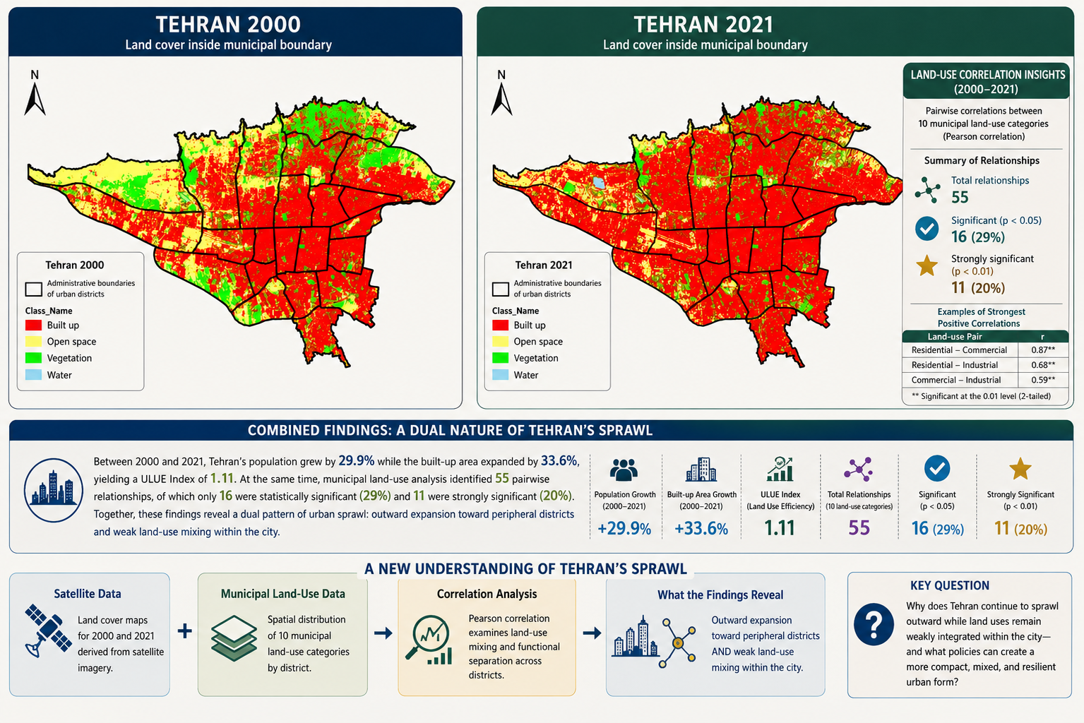
When we began studying urban growth in Tehran, we initially expected urban sprawl to appear mainly as outward physical expansion. Satellite imagery certainly confirmed substantial urban growth over the past two decades. Built-up areas expanded rapidly, particularly toward lower-density peripheral districts.
However, the satellite data revealed only part of the story.
🛰️ To gain a deeper understanding, we combined satellite-derived land-cover information with detailed land-use data from Tehran Municipality.
This integration revealed a second and less visible form of sprawl.
While the city expanded physically at its edges, many urban functions within the city remained spatially separated. Residential, commercial, educational, healthcare, recreational, and service activities often remained weakly integrated.
🔎 This finding changes how we understand urban sprawl.
Traditional definitions often focus on physical expansion. Our results suggest that functional separation can be just as important as physical growth.
Satellite data show where urban expansion occurs.
Municipal land-use data explain why people travel.
Together, they reveal how low-density peripheral development and weak land-use mixing combine to generate longer daily journeys.
🚗 Residents frequently travel across multiple districts for employment.
🎓 Students travel considerable distances for education.
🏥 Healthcare services are concentrated in specific locations.
🛒 Shopping and administrative services often require cross-city trips.
The result is increasing dependence on automobiles, higher fuel consumption, growing congestion, and worsening air quality.
🌍 What can Tehran learn from international examples?
Paris, Barcelona, and Melbourne demonstrate that proximity planning can significantly reduce unnecessary travel.
However, our findings suggest that Tehran does not need a direct copy of European or Australian models.
Instead, it needs a localized version of the 15-minute or 20-minute city concept.
🏘️ In peripheral districts, strengthening local service hubs could reduce forced travel.
🚸 In central districts, street redesign and traffic-calming measures could improve walkability and reduce car dependence.
🚇 Across the metropolitan area, targeted public transport investments could improve accessibility and spatial equity.
🗺️ Most importantly, GIS, remote sensing, and municipal land-use databases can help planners identify where interventions are most urgently needed.
🎯 Beyond Tehran
Many rapidly growing cities across Asia, Africa, Latin America, and the Middle East face similar challenges. Physical expansion is often visible, but functional sprawl may remain hidden.
Our study demonstrates how integrating satellite imagery with municipal planning data can reveal both dimensions simultaneously.
💬 Looking ahead
Can satellite–municipal data integration help megacities identify hidden forms of urban sprawl and move closer to the vision of cleaner, fairer, and more accessible neighbourhoods?
I welcome discussion and collaboration from researchers and practitioners working in urban planning, transport, GIS, remote sensing, accessibility, air quality, and sustainable urban development.
Head of Public Transportation, Tehran Municipality District 22 | Transportation Planning Specialist | 15+ years municipal experience | Sustainability & Climate Researcher: sustainable cities, GIS/Remote Sensing, air quality, methane monitoring & net-zero transition | ✍️ 9 research publications (incl. 5 Q1/Q2), 43 citations & 11 journal reviews | 🖨️ Recent research: Australia methane, Tehran spatial equity & Canada air pollution | 🤝 Collaborations with a Top 2% global scientist and an Australian Principal Scientist | 🎯 Translating research into climate policy & sustainable mobility.
Follow the Topic
What are SDG Topics?
An introduction to Sustainable Development Goals (SDGs) Topics and their role in highlighting sustainable development research.
Continue reading announcement


Please sign in or register for FREE
If you are a registered user on Research Communities by Springer Nature, please sign in