THE BEGINNING OF AN ADDRESS: Behind the Research on Terrestrial LiDAR Mapping in Brazilian Favelas
Published in Sustainability, Civil Engineering, and Arts & Humanities


In Brazil, even when favelas are mapped (often as a blob on the map), one of the most meaningful absences is lack of addresses. People live there, in houses charged with physical, social, and emotional values. And yet, streets go unnamed and homes remain invisible on official maps. Without addresses, people might have basic rights denied, from enrolling kids in schools to find a job. Part of these people's identity is denied. Thus, mapping is never a neutral technical exercise, and to be mapped is to have its existence acknowledged.
Favelas have often been documented from above, through aerial photogrammetry. From that perspective, a large mass of connected rooftops can appear almost amorphous. Yet beneath those roofs, much of urban life takes place. Narrow alleys, stairways, covered passages, entrances, façades, and infrastructure elements shape the everyday spatial reality of these places. If the goal is to understand the built environment in a way that can support planning and intervention, then ground-level spatial information is essential.
This terrestrial dimension became the key to this study. Terrestrial LiDAR is a way of moving closer to the lived space of the favelas. Mapping from the ground also means becoming present. It means entering the area, being seen, being questioned, explaining why you are there, and recognizing that cartography is not produced by technology alone. It is also produced through presence.
In territories where formal recognition has historically been incomplete, mapping advances through a degree of openness, trust, and negotiation. It requires dialogue with those who live there and know the area deeply. This is as much a practical matter as an ethical one. The closer cartography gets to the ground, the closer it also gets to the people whose lives are already inscribed there.
Our discomfort found an address: Jardim Colombo, part of the Paraisópolis complex, one of the largest favelas in Latin America, in São Paulo, Brazil, where complex morphology is a daily condition. We designed a route as a small but meaningful sample of spatial situations commonly found in informal settlements. Representativeness was the criterion. The route included steep slopes, uneven terrain, stairways, narrow pedestrian alleys, streets shared with cars, passages covered by buildings, open stretches with a stream, and areas with debris. We wanted to test the devices not in ideal conditions, but in the kind of environment where favela mapping actually takes place.
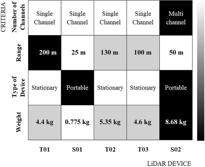
Five different LiDAR devices were used along this same representative route in Jardim Colombo, allowing us to compare their results under the same spatial conditions. We tested the devices in real conditions. We compared them along the same path in this dense informal settlement, in direct interaction with stairs, weight, time, obstruction, and the body of the person carrying them. This meant that technical quality and field practicality had to coexist. We compared density, completeness, and uniformity, but also logistical criteria.
To compare the LiDAR datasets reliably, we needed a common georeferenced base. We therefore combined drone imagery, GNSS, total station data, and reference points surveyed in the field. In practice, this was the quiet structure that made the comparison trustworthy. It allowed us to move from isolated captures to comparable evidence. The visual power of a point cloud is compelling. Even more compelling was the effort to establish criteria for comparing one cloud to another.
As the analysis progressed, one conclusion became increasingly clear: there is no absolute winner. Real decisions are rarely made by looking only at a specification sheet. They involve trade-offs. Access matters. Weight matters. Duration matters. Intended use matters. A researcher, surveyor, or public agency working in a favela needs more than a technical promise. They need to understand suitability in context.
For a long time, favelas have been treated as exceptions within urban systems, difficult to map, difficult to classify, difficult to fit into tools designed for other kinds of urban form. But perhaps the problem is not that favelas are illegible. Perhaps the problem is that our tools, categories, and official representations have been too limited to read them well. Better data does not automatically produce social justice. A point cloud does not solve inequality. A precise survey does not guarantee a good urban project. But the lack of representation can reinforce neglect. A better representation, by contrast, can support planning, dialogue, and a more careful reading of what is already there.
That is also why open data matters here. Making this dataset public was not only a matter of transparency or reproducibility. It was also a refusal of the idea that these territories should remain data-poor. What is missing from the map is more likely to remain missing from research, models, tools, and public policy.
At a deeper level, this paper remains connected to the same question that has guided our work for years: what does it mean, after all, for a place to be seen?
Not looked at from afar. Not generalized. Not reduced to a blank area or a homogeneous patch. But truly seen in its form, its density, its irregularity, its difficulty, and its life. Behind this paper, there is, of course, a comparison between LiDAR devices. There are metrics, workflows, field surveys, and technical validation. But there is also a more persistent concern. If a place has been represented for so long as if it were not fully there, then perhaps every better representation is also, in some small way, the beginning of an address.
This work was developed as part of my doctoral research under the supervision of Prof. Angélica Alvim, whose guidance has been fundamental throughout this journey. This research was supported by Coordenação de Aperfeiçoamento de Pessoal de Nível Superior (CAPES) and conducted with institutional support from the Senseable City Lab at the Massachusetts Institute of Technology (MIT).
Architect, researcher, and innovation manager based in São Paulo, Brazil.
My work explores how technologies such as LiDAR, photogrammetry, BIM, and spatial data can support more inclusive urban interventions, especially in Brazilian informal settlements.
I am currently pursuing a PhD on mapping and dialogue in favelas while leading innovation initiatives in engineering and infrastructure.
Interested in urban data, participatory mapping, spatial justice, and emerging technologies for more equitable cities.
Follow the Topic
-
Scientific Data
A peer-reviewed, open-access journal for descriptions of datasets, and research that advances the sharing and reuse of scientific data.

What are SDG Topics?
An introduction to Sustainable Development Goals (SDGs) Topics and their role in highlighting sustainable development research.
Continue reading announcementRelated Collections
With Collections, you can get published faster and increase your visibility.
10 years of the FAIR principles
Publishing Model: Open Access
Deadline: Nov 14, 2026
Data to support cancer treatment, diagnosis, and disease understanding
Publishing Model: Open Access
Deadline: Jan 02, 2027