Unmasking Kolkata’s Air: Tracking Pollution Patterns and Hidden Drivers
Published in Earth & Environment and Sustainability
In eastern India, Kolkata stands as a city of deep cultural heritage and intellectual history, yet it now faces an escalating crisis of air pollution. Once celebrated for its artistic and academic vibrancy, the city of over four million residents is increasingly burdened by toxic gases and particulate matter that compromise daily life. A recent study led by Dr. Sumanta Das of the Ramakrishna Mission Vivekananda Educational and Research Institute, in collaboration with the West Bengal Pollution Control Board, offers one of the most comprehensive examinations yet of this invisible threat. Through the integration of five years of monitoring data, advanced geospatial techniques, and meteorological analysis, the research delivers a multidimensional portrait of Kolkata’s air and provides pathways toward targeted solutions.
The study is driven by an urgent national context: India accounts for 21 of the world’s 30 most polluted cities, and Kolkata consistently ranks among them. While Delhi’s notorious smog often dominates public attention, Kolkata’s long-term air quality dynamics have been less rigorously documented. Past studies tended to focus on specific seasons or short-term conditions, offering fragmented insights into a problem that unfolds continuously and is shaped by a range of human and climatic forces. Dr. Das and his team sought to bridge this gap by conducting a sustained, multi-year investigation that captures both the citywide extent of pollution and its shifting patterns over time.
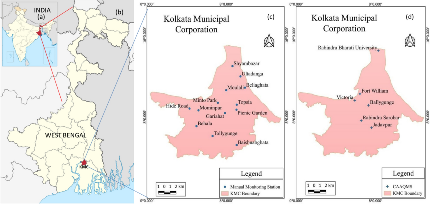
What distinguishes this research is its methodological innovation. The team drew on data from thirteen manual air quality stations and seven automated continuous monitoring stations maintained by the Kolkata Municipal Corporation. These provided measurements of critical pollutants, including PM₂.₅, PM₁₀, nitrogen dioxide (NO₂), and sulfur dioxide (SO₂). Instead of analyzing these values in isolation, the researchers applied Inverse Distance Weighted interpolation, a geospatial method that transforms scattered readings into continuous surfaces. This enabled the creation of high-resolution pollution maps that reveal how contaminants accumulate and disperse across neighborhoods. By coupling these spatial models with meteorological records from the India Meteorological Department, the team was able to identify how weather and climate interact with emissions to shape Kolkata’s atmospheric health.
The results highlight persistent hotspots that encapsulate the diversity of Kolkata’s air quality challenges. Hide Road, an industrial belt adjacent to a thermal power plant; Shyambazar, a dense traffic interchange; Moulali, a mixed-use hub marked by informal waste burning; Ultadanga, a transport-heavy corridor with dense slums; and Minto Park, a construction-dominated commercial district—all consistently registered dangerous pollution levels. Each hotspot reflects a different facet of the problem: industrial emissions, vehicular congestion, informal settlement practices, or construction-related dust. These findings reveal that air pollution is not uniform but deeply tied to the city’s socioeconomic and spatial structures.
Particulate matter emerged as the most pressing pollutant. PM₁₀ levels routinely exceeded national safety thresholds, while PM₂.₅ concentrations in 2023 were particularly alarming, surpassing permissible limits at nearly every site. PM₂.₅ is especially dangerous due to its ability to penetrate deep into the respiratory system. High levels were recorded in Mominpur, Topsia, and Moulali—areas marked by a convergence of heavy traffic and informal housing. Nitrogen dioxide, primarily from vehicular combustion, spiked sharply in 2023, indicating a resurgence in emissions following the pandemic lockdowns. While sulfur dioxide was generally lower, its episodic surges in neighborhoods like Beliaghata, Behala, and Mominpur pointed to the continued role of small-scale industries and biomass burning.
The study also underscored the importance of meteorology as a governing factor in air quality. Pre-monsoon heat was associated with declines in PM₂.₅, likely due to enhanced vertical mixing and chemical breakdown in hotter conditions. Rainfall during the post-monsoon period acted as a natural purifier, washing pollutants from the air. Humidity, however, produced more complex effects: while it helped suppress particulate matter and nitrogen oxides, it correlated with higher sulfur dioxide levels during the monsoon, suggesting secondary chemical transformations. These nuanced seasonal dynamics demonstrate that Kolkata’s air cannot be disentangled from its climate rhythms, and effective management must align with these temporal cycles.
A particularly revealing aspect of the study was its ability to capture the pandemic’s imprint on the city’s air. In 2020 and 2021, lockdowns brought traffic and industry to a halt, and the air cleared significantly, offering residents a rare glimpse of a cleaner environment. Yet by 2023, as activity rebounded, pollution not only returned but in some areas exceeded pre-pandemic levels. This rebound highlights both the temporary nature of short-term improvements and the necessity of systemic reforms in sectors such as transport, industry, and waste management if lasting change is to be achieved.
Beyond documenting trends, the study contributes a framework for targeted policy action. By correlating pollutant profiles with neighborhood-specific conditions and meteorological drivers, it generates a detailed map of vulnerabilities and intervention points. Hide Road demands industrial emission control and cleaner energy transitions, Shyambazar and Ultadanga require transport reform and congestion management, Moulali calls for stricter regulation of waste burning and improved energy access in slum areas, while Minto Park illustrates the need for dust mitigation at construction sites and improved urban ventilation. These location-specific strategies move the discussion away from generic prescriptions toward precision-targeted governance.
The research also highlights the social inequities embedded in Kolkata’s pollution landscape. Many of the most polluted areas coincide with wards that have high concentrations of slum dwellers, who are simultaneously the most exposed and the least empowered to change conditions. Their reliance on biomass fuels and informal waste disposal contributes to emissions, but it also reflects structural inequalities in energy and housing access. By situating air pollution within these lived realities, the study frames clean air as both an environmental and social justice imperative.
Looking ahead, the scientists recommend strengthening Kolkata’s monitoring network through the integration of low-cost sensors and satellite-based observations to fill data gaps. They suggest employing advanced source apportionment methods such as Positive Matrix Factorization to precisely attribute pollutants to different sources. Coupling geospatial data with machine learning could further enhance predictive modeling, enabling early warning systems and proactive interventions. Such innovations would transform Kolkata into a model for sustainable urban air governance, with lessons applicable across the Global South.
More information:
Chakroborty, B., Rudra, K., Chakrabarty, D. et al. Decoding spatiotemporal dynamics of air pollution and its underlying drivers in Kolkata metropolitan area through integrated field investigation and geospatial analysis. Discov Cities 2, 77 (2025). https://doi.org/10.1007/s44327-025-00118-7
Follow the Topic
-
Discover Cities
This is a fully open access, peer-reviewed journal that supports multidisciplinary research and policy developments across the field of urban science.

Related Collections
With Collections, you can get published faster and increase your visibility.
Spatio-temporal Big Data: Enabling Urban Land Use and Climate Change for Sustainability
With the acceleration of global urbanization and the intensification of climate change, cities are facing unprecedented challenges and opportunities. Urban land use patterns not only directly affect the economic, social, and environmental sustainability of cities but also determine their adaptive capacity and resilience to climate change. Meanwhile, extreme weather events, rising temperatures, and sea-level rise brought about by climate change pose higher demands on urban land use and infrastructure. Therefore, how to address climate change through optimized land use and enhanced urban resilience has become a key issue for urban sustainable development.
In recent years, the rapid development of spatio-temporal big data technology has provided new ideas and tools for solving this complex problem. Spatio-temporal big data, encompassing various data sources such as Geographic Information Systems (GIS), remote sensing, Internet of Things (IoT), and mobile data, offers high-resolution and multi-dimensional spatio-temporal information. These data not only enable more precise monitoring and analysis of urban land use changes but also reveal the mechanisms by which climate change impacts urban systems. Moreover, combined with advanced analytical techniques such as machine learning, deep learning, and statistical modeling, spatio-temporal big data can provide scientific evidence for urban planning, policy-making, and resource management, thereby facilitating the achievement of urban sustainable development goals.
This collection aims to gather cutting-edge research findings on the application of spatio-temporal big data in urban land use and climate change, exploring how data-driven approaches can optimize urban land use, enhance urban resilience, and promote urban sustainable development. We welcome researchers from multidisciplinary fields such as geographical sciences, urban planning, environmental science, climate science, and data science to submit original research papers, review articles, and case studies to jointly advance the theoretical and practical development of this interdisciplinary field.
The research collected in this series includes, but is not limited to, the following topics:
1. Application of Spatio-temporal Big Data in Urban Land Use Monitoring and Assessment
- Land use change analysis based on remote sensing and GIS
- Modeling urban expansion and land cover changes using spatio-temporal big data
- Assessing and optimizing urban land use efficiency
2. Impact of Climate Change on Urban Land Use
- Impacts of extreme weather events on urban land use and corresponding responses
- Relationship between urban heat island effects and land use under climate change
- Effects of sea-level rise on land use in coastal cities and adaptation strategies
3. Application of Spatio-temporal Big Data in Urban Climate Resilience
- Urban flood risk assessment and management using spatio-temporal big data
- The role of urban ecosystem services in climate change adaptation
- Assessing and enhancing urban infrastructure resilience to climate change
4. Spatio-temporal Big Data and Urban Sustainable Development Planning
- Developing urban sustainability indicators using spatio-temporal big data
- Climate change adaptation in urban land use planning
- Synergistic optimization of urban transportation, energy, and land use
5. Interdisciplinary Research on Spatio-temporal Big Data
- Economic analysis of urban land use and climate change
- Social equity perspectives on urban land use and climate adaptation
- Spatio-temporal big data analysis of urban health and well-being
Keywords:Spatio-temporal Big Data; Urban Land Use; Climate Change; Urban Planning; Sustainable Development; Urban Economics; Machine Learning; Carbon Emissions; Ecosystem Services; Urban Resilience, Smart Cities
Publishing Model: Open Access
Deadline: Dec 30, 2026
Urban Futures: Strategies for Decarbonized, Resilient, and Equitable Cities
Cities stand at the forefront of the global sustainability challenge. This Collection explores how urban areas can become drivers of climate action, social equity, and systemic transformation. Drawing from contributions presented at the Urban Futures Symposium 2025 (hosted by the Urban Energy Systems Laboratory at Empa, Switzerland), this Collection brings together research, practice, and policy insights on how to build decarbonized, resilient, and equitable cities.
The articles cover a wide range of themes, including integrated urban energy systems, low-carbon mobility, participatory governance, just and equitable transitions, sufficiency-based planning, nature-based solutions, circularity, embodied emissions, digital urban innovations, financing and economics, and building and energy technologies. With case studies from cities across the Global North and South, and perspectives from both academic and practitioner communities, the Collection highlights interdisciplinary and cross-scale strategies for navigating urban complexity in a rapidly changing world.
We invite contributions that explore theoretical frameworks, empirical studies, modeling approaches, or co-designed solutions for shaping just, climate-compatible urban futures.
Keywords: Urban transitions; Urban resilience; Participatory urban planning; Justice, equity, and well-being; Urban governance and policy; Integrated energy systems and technologies; Sustainable mobility; Sufficiency strategies; Circular economy and resource flows; Materials and embodied emissions; Nature-based solutions; Urban ecology and environmental systems; Financing mechanisms and urban economics; Innovations in the built environment; Systemic innovation for urban sustainability.
This Collection supports and amplifies research related to SDG 11 (Sustainable Cities and Communities), SDG 7 (Affordable and Clean Energy), SDG 13 (Climate Action), SDG 12 (Responsible Consumption and Production), and SDG 10 (Reduced Inequalities).
Publishing Model: Open Access
Deadline: Dec 31, 2026
Please sign in or register for FREE
If you are a registered user on Research Communities by Springer Nature, please sign in