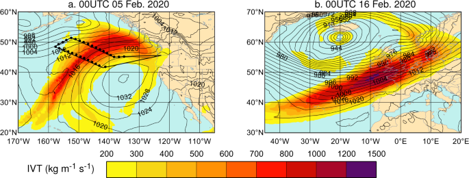
“What was the cause of the extreme flooding?” This is a common question that arises following a flood event. Frequently the answer in the middle latitudes, such as Western Europe and western North America, is an atmospheric river. Atmospheric rivers (ARs) are low-altitude features that transport vast amounts of water vapour through the atmosphere. On occasions these contain larger freshwater fluxes than those at the outlet of the Amazon River. They are of great interest to the scientific community, weather forecasters, and organisations responsible for flood preparedness because of their links to flooding and water resources; and this interest has grown rapidly in the last decade.
Our perspective article on improving forecasts of ARs comes at an exciting time and following important developments in AR science. Of particular note is the operational observational campaign across the northeast Pacific Ocean, AR Reconnaissance, a program which, for example, uses National Oceanic and Atmospheric Administration (NOAA) and US Air Force aircraft to release dropsondes to sample ARs (dropsondes measure properties of the atmosphere, such as the temperature, winds, and humidity). The breadth of AR Recon activities was highlighted in February 2020 when David Lavers was privileged to see at first hand the workings of a NOAA flight. At 45,000 feet, looking across the Pacific Ocean, the progress being achieved in AR forecasting was plain to see through the teamwork that made the collection of AR observations possible. Observations improve knowledge and forecasts and thus another complementary step has been the development of forecast products tailored towards ARs, these being an index that expresses how extreme a water vapour flux is and the AR scale. We illustrate their benefits in the article.
It was also in February 2020 that ARs were brought to the public attention, when storm Dennis and its heavy precipitation caused widespread flooding and significant socioeconomic damages in northwest Europe. A discussion with the Editor of Communications Earth & Environment came soon afterwards, and we proposed a perspective article to build on the current momentum in AR science in order to further advance our forecasting capabilities. This envisions an interdisciplinary European–American observational campaign in the North Atlantic to identify and address numerical weather prediction errors in ARs, an idea that we have been thinking about for a few years. Together with modelling improvements and insights on river basin properties, we suggest the global water cycle and extreme events may be forecast more skilfully leading to societal benefits.
Follow the Topic
-
Communications Earth & Environment

An open access journal from Nature Portfolio that publishes high-quality research, reviews and commentary in the Earth, environmental and planetary sciences.
What are SDG Topics?
An introduction to Sustainable Development Goals (SDGs) Topics and their role in highlighting sustainable development research.
Continue reading announcementRelated Collections
With Collections, you can get published faster and increase your visibility.
Archaeology & Environment
Publishing Model: Hybrid
Deadline: Mar 31, 2026
Drought
Publishing Model: Hybrid
Deadline: Mar 31, 2026


Please sign in or register for FREE
If you are a registered user on Research Communities by Springer Nature, please sign in