Which Satellite Precipitation Dataset Should We Trust in Complex Terrain? Lessons from Taiwan
Published in Earth & Environment and Research Data
Research often begins with a simple question. For this study, the question was: How reliable are satellite precipitation datasets in a region with complex terrain like Taiwan?
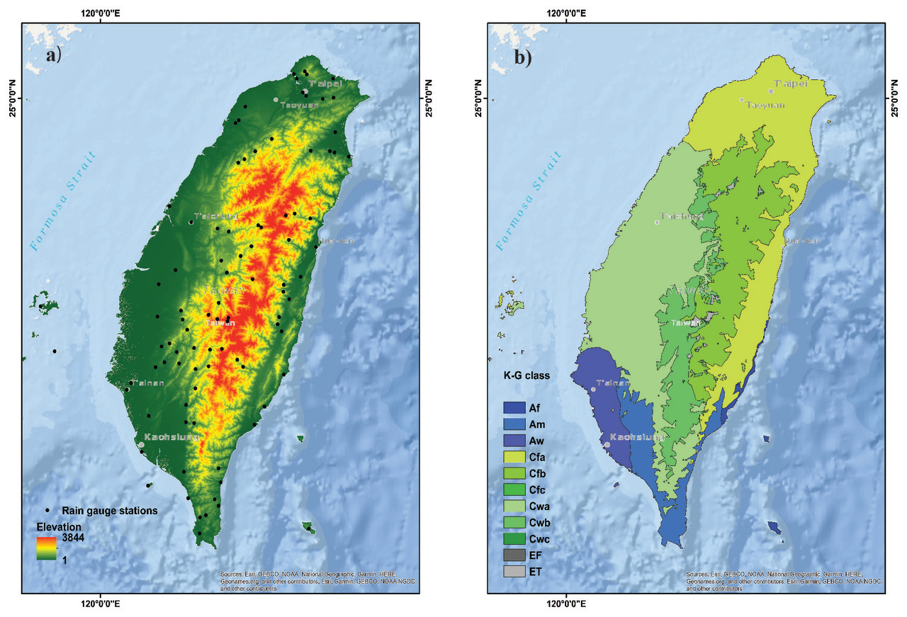
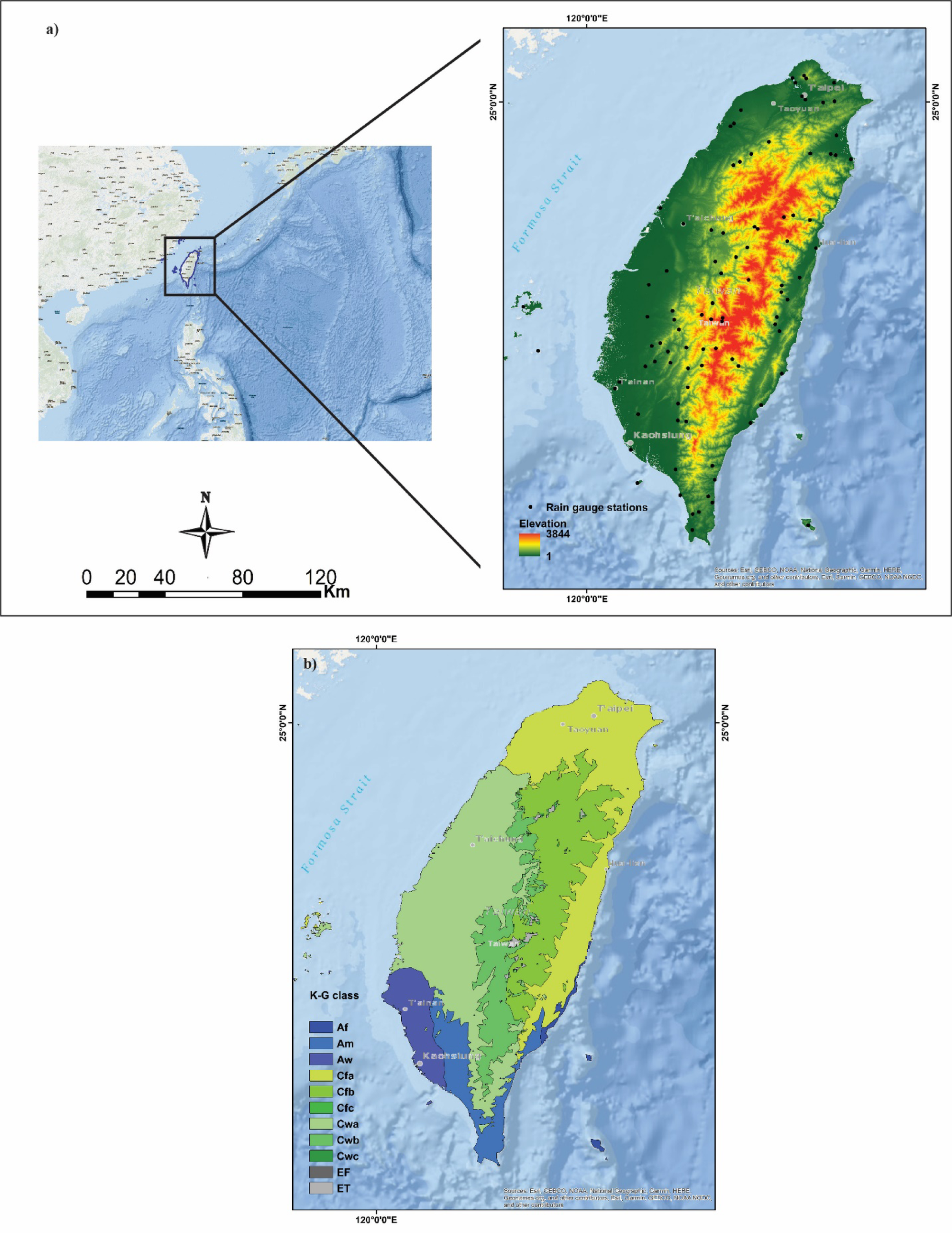
Taiwan experiences some of the most intense rainfall events in the world, particularly during typhoons, when daily rainfall can exceed 1000 mm. Accurate precipitation information is therefore critical for flood forecasting, landslide risk assessment, and water resource management. However, obtaining reliable precipitation data in such environments is not straightforward.
Rain gauges provide precise measurements, but their distribution is sparse in mountainous regions. Radar observations are useful for monitoring storms, yet they often suffer from terrain blockage in the Central Mountain Range. Because of these limitations, researchers and practitioners increasingly rely on satellite precipitation products (SPPs).
While working on hydrological and climate studies related to Taiwan, we repeatedly encountered an important issue: different satellite datasets often give different results. This raised an important research question—which dataset should we trust, and under what conditions?
To explore this, we conducted a 20-year evaluation (2000–2020) of four widely used satellite precipitation products—IMERG, CHIRPS, PERSIANN-CDR, and TRMM—using observations from 87 rain gauge stations across Taiwan. The analysis examined performance across multiple temporal scales, different Köppen–Geiger climate zones, elevation gradients, and long-term trends.
One of the key insights from this study is that there is no universally “best” satellite precipitation dataset. Instead, each product has its own strengths:
-
IMERG performs particularly well in detecting precipitation events, making it useful for hazard monitoring and event-based applications.
-
CHIRPS provides more reliable estimates of precipitation magnitude, which is important for hydrological modeling and water resource studies.
Another interesting finding is the strong influence of topography. Satellite precipitation accuracy generally decreases at higher elevations, highlighting the persistent challenge of monitoring rainfall in mountainous regions.
For us, this work was not only about evaluating datasets. It was also about understanding how satellite observations can be used more effectively in complex environments where ground observations are limited but accurate precipitation information is essential.
We hope this study contributes to improving the use of satellite precipitation products for hydrological research, climate analysis, and disaster risk reduction in mountainous and hazard-prone regions.
Follow the Topic
-
Sustainable Water Resources Management

This journal publishes articles that deal with the interface of water resources science and the needs of human populations, highlighting work that addresses practical methods and basic research on water resources management.
Related Collections
With Collections, you can get published faster and increase your visibility.
VII RAGSU – Advances in Environmental Geochemistry and Sustainable Water Resources in Latin America
The proposed Special Issue, “VII RAGSU – Advances in Environmental Geochemistry and Sustainable Water Resources in Latin America”, will compile selected peer-reviewed papers presented at the VII Argentine Meeting on Surface Geochemistry (RAGSU 2025). This collection aims to highlight recent advances in environmental and surface geochemistry research with direct implications for water resources management, sustainability, and environmental studies.
The RAGSU meetings, held regularly in Argentina since 2009, constitute a leading regional forum for presenting and discussing scientific progress in surface geochemistry, covering diverse environments such as marine, fluvial, wetland, saline, soil, and groundwater systems. Research topics include environmental geochemistry, hydrogeochemistry, biogeochemical processes, isotopic and experimental geochemistry, and the geochemistry of natural and anthropogenic impacts on surface and subsurface environments.
This Special Issue is timely and relevant as it brings together recent studies addressing pressing issues related to water quality, groundwater–surface water interactions, contaminant dynamics, nutrient cycling, and the sustainable use of water resources in the context of agricultural and urban pressures. Many of these studies originate from Latin America (a region where water management challenges are intensified by climate variability, land-use change, and socio-economic constraints) yet often remain underrepresented in international literature.
The proposed collection fits naturally within the aims and scope of Sustainable Water Resources Management by integrating fundamental and applied geochemical research that supports sustainable water resource strategies.
It will provide valuable insights from developing regions, aligning with the journal’s mission to promote global knowledge exchange between researchers from developing and developed countries. By fostering interdisciplinary collaboration among geochemists, hydrologists, and environmental scientists, this issue will contribute to the understanding of hydrogeochemical processes that underpin sustainable management of both surface and groundwater systems.
Publishing Model: Hybrid
Deadline: Mar 31, 2026
Please sign in or register for FREE
If you are a registered user on Research Communities by Springer Nature, please sign in