Geoscience Diplomacy with Iran in Hormuz Region
Published in Social Sciences, Earth & Environment, and Sustainability
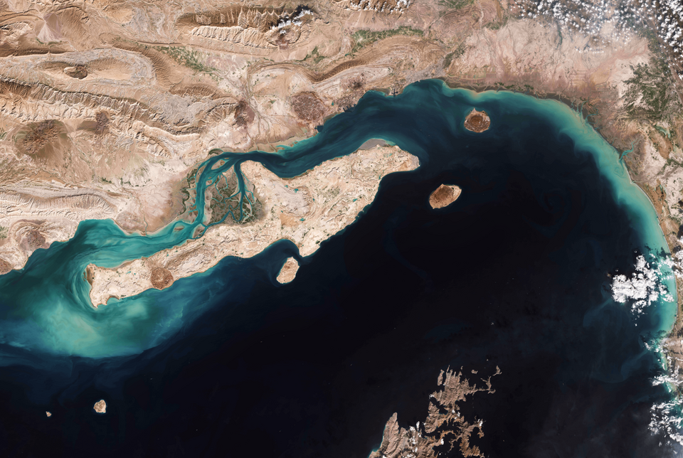
 that was bombed on June 2, 2026")
The current conflict between Iran, Israel and the United States has unexpectedly become anchored in the Arabian/Persian Gulf, and most notably around the Straits of Hormuz. So far most of the conflict resolution process presents contested views of what constitutes “innocent passage” or “transit passage” and the ratification status or lack thereof of the United Nations Convention on the Law of the Sea (UNCLOS). The closest comparative case is the Straits of Malacca where all littoral states (Indonesia, Malaysia, Thailand and Singapore) have ratified UNCLOS. They have also established a cooperative mechanism that was facilitated by the International Maritime Organization. Indonesia has suggested a way to monetize services (pilotage, safety, environmental protection) under Article 43 of UNCLOS rather than tolling passage itself. This kind of “service based” tolling could also be an off ramp for Iran and the United States.
However, neither the United States nor Iran have ratified the UNCLOS treaty (UAE and Iran are both signatories but have not ratified). All other bordering states (Saudi Arabia, Iraq, Kuwait, Bahrain, Qatar and Oman) have ratified UNCLOS. Given the lack of ratification of UNCLOS by Iran and the UAE any cooperative agreement which looks to this convention as a path to resolution is unlikely to be successful. Instead, it is worth considering the geology of the Gulf and the Strait as a less polarizing path for cooperation. There is a fascinating geological history for the Strait and the Gulf which owe to their formation due to the collision of the Arabian and Eurasian plates around 30 million years ago and is also linked to why this area is so rich in fossil fuels. This geology may lead us towards a more "science-based" opportunity for dialogue.
Continental Connectivity
Since the Gulf is essentially a single, continuous shallow trough rather than an oceanic basin, the entire seabed technically qualifies as “continental shelf” — there is no deep ocean floor separating Iran's landmass from the opposite shore. This means all the littoral states are sitting on each other's continental shelf extensions. Such inherent continental connectivity is why Iran and Qatar also amicably “share “the world’s largest gas field (the South Pars field), that was also threatened during the current conflict. This physical geography was most consequential around 20,000 years ago during the Last Glacial Maximum when the water in the Gulf was so shallow you could have walked across it in certain points. As ice sheets began to melt, global sea levels rose substantially — about a hundred meters. Unfortunately, International Maritime Law has not engaged adequately with climate change. Yet it is climate change that created the physical divisions that now separate Iran from Arabia, Malaysia from Sumatra and for that matter Alaska from Chukotka.
Indeed, the Bering Land Bridge that likely led to the migration of humans from Asia to the Americas has been recognized by Russia and the United States as an ecologically and culturally significant locale for cooperative outcomes. Various agreements in different stages have been developed for unrestricted passage through this region. Most significantly, President Reagan and President Gorbachev established the Beringian Heritage Program that is focused on science and conservation as a means of diplomatic engagement between the two countries that have been adversaries for much of the past century. This program of cooperative trust between rivals in a maritime passageway for environmental conservation may lead to another entry point on conflict resolution in Hormuz.
UNESCO’s Cooperative Interface
The United Nation’s Educational, Scientific and Cultural Organization (UNESCO) has been under fire by the Trump administration and Israel for having admitted Palestine as a member. Famously the US has withdrawn from the organization, but that formal departure does not come into effect until December 31 of 2026. Therefore, there is an opportunity for engagement with Iran by the US via UNESCO as well by noting the global ecological and geological heritage value of having the Straits and the Gulf open for all. Iran has been a vibrant participant in UNESCO’s geopark program as well as its Man and the Biosphere Programme. Other neighboring Gulf States are also active participants.
In particular, Qeshm Island is a UNESCO Global Geopark (this island was bombed by the United States on June 2, 2026 testing the fragile ceasefire). Saudi Arabia also has two Geoparks and there is a provision under UNESCO’s management of such systems for having “transboundary” reserves and parks. The Hormuz region and the islands could be declared transboundary Geoparks. The United Arab Emirates also has declared Marawah island a Biosphere reserve under the UNESCO program. Qatar has similarly designated the coastal Al Reem region to be a similar reserve. With this interconnected "necklace" of reserves and geoparks, there may be an opportunity to find a workable exit strategy for any “tolling” going towards conservation or other nonmilitary activities related to coastal development across the region. Given the impasse over the Hormuz tolls issue, such an environmental peacebuilding path deserves serious and imminent consideration.
Saleem H. Ali is the Blue and Gold Distinguished Professor of Energy and the Environment at the University of Delaware (joint tenured appointments in Geography and the Joseph Biden School of Public Policy); Senior Fellow at Columbia University's Center on Sustainable Investment; Lead for Critical Minerals at United Nations University (INWEH), and Honorary Professor at the University of Queensland (Australia). He is also a member of the United Nations International Resource Panel and served 2 terms on the Scientific and Technical Advisory Panel of the Global Environment Facility. His latest book is Sustainability: A Very Short Introduction. Other works include Earthly Order: How Natural Laws Define Human Life (Oxford University Press, 2022) and Soil to Foil: Aluminum and the Quest for Industrial Sustainability (Columbia University Press, 2023). Twitter @saleem_ali
Follow the Topic
Introducing: Social Science Matters
Social Science Matters is a campaign from the team at Palgrave Macmillan that aims to increase the visibility and impact of the social sciences
Continue reading announcement


Please sign in or register for FREE
If you are a registered user on Research Communities by Springer Nature, please sign in