Mapping the Impact of Geoclimatic Factors on Pesticide Accumulation: Towards a Data-driven Sustainable Pesticide Management
Published in Earth & Environment and Agricultural & Food Science

Story behind the Paper
Kishalay Chakraborty is from Assam state, India. He was enrolled in PhD program, Japan from October 2020.
He could not come to Japan physically, due to COVID-19 prevalence. He could not perform his research proposal on pesticide biosensor development. We had online meetings regularly. We continuously discussed what research we could conduct during the COVID-19 pandemic or what research we could leverage the unique circumstances of the pandemic. Our answer is to undertake computer simulation, utilizing Kishalay’s expertise, programing skills.
When one door closed another one opens; but we so often look so long and so regretfully upon the closed door that we do not see the ones which open for us (Alexander Graham Bell)
First, we investigated computational studies on pesticide pollution, and found the potential of Bioreactive Transport Simulator, which was used to simulate the pesticide accumulation globally (see the example).
The simulation needs the input data. Kishalay visited two research institutions in Assam, and came to know the way to collect the soil health data of Indian farms. One Indian public database already provides farm data, which can be used as the input for simulation. We thought that by combining the simulator and farm-level data, we could visualize possible patterns of pesticide accumulation in Indian soil. Kishalay contacted the simulator’s inventor, Prof. Federico Maggi, who kindly provided the simulator to us along with his valuable guidance.
Our study shown here was not designed from the beginning. But the unexpected situation allowed us to conceive it and press on this research project.
Background
Agriculture has been essential to human civilization, helping to feed the global population. Pesticides are widely used for crop protection, reducing yield loss and ensuring consistent quality. Pesticides accumulate in soil. Pesticide overuse causes significant risks to the environment and human health by contaminating food, soil, and water, reducing biodiversity, and compromising soil quality. Human health is dependent on the health of the planet, planetary health.
Organic and natural farming, while environmentally friendly, should face challenges in meeting global food demand due to the increasing population. Therefore, responsible pesticide use, integrated with sustainable practices, is necessary to ensure food security and planetary health.
Pesticide accumulation (dynamics) has been evaluated by both experimental and simulation methods. Although precise, experimental methods are not feasible for large-scale screening due to their high cost and time consumption, making it challenging to capture the overall picture of pesticide accumulation using experimental methods alone. On the other hand, recent computational models allow us to grasp pesticide accumulation at countrywide or global scale by incorporating environmental factors such as soil texture and climate data. The simulation results can be shown on a map.
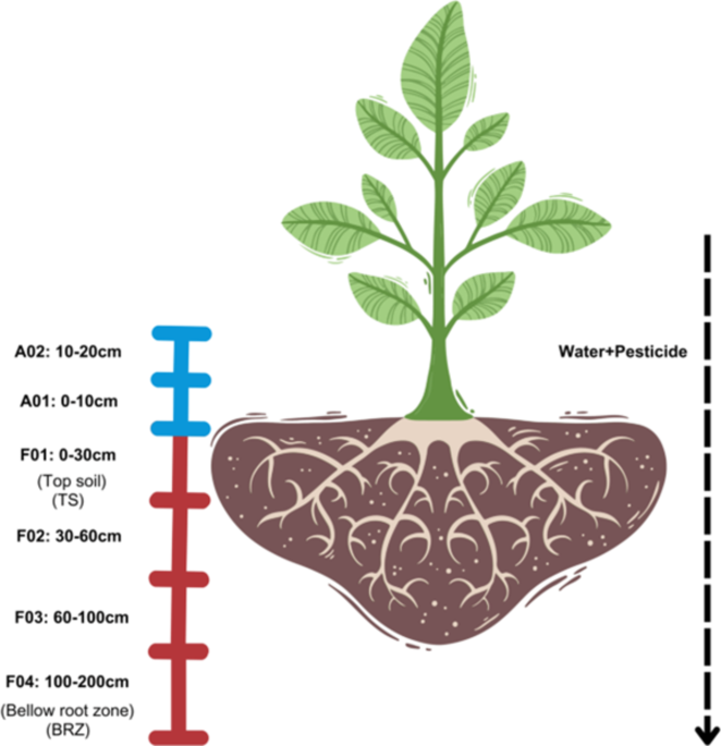
The aim of this study is to visualize emerging patterns in pesticide accumulation in farm soil (the smallest unit in agriculture), considering India as an example. Modeling tool called Bioreactive Transport Simulator (BRTSim) was used to predict the pesticide concentrations over time in 19,573 Indian farms based on Soil Health Card data (available from the Indian government’s public database) and high-resolution climate data. In this simulation, we considered a hypothetical scenario in which a constant pesticide application rate was maintained across all farms. To confirm if the steady state was achieved at the topsoil pesticide concentration, we looped the available five (05)-year data four (04) times to achieve a 20-year timeline.
Key Insights
Pesticide behavior varies across locations
Take a look at the video. It is a time-lapsed, pesticide-wise video based on our simulation results. Annual variations of predicted leaching from the topsoil to below root zone (100-200 cm) are shown for 46 pesticides used in India. Each dot represents a unique village: 3,861 dots cover 19,573 Indian farms in total.
During a 20-year simulation, the dot color gradually turns from yellow to blue (low to high). Pesticides that leach into below root zone tend to persist longer, posing potential risks to groundwater quality and overall soil health. The video shows that pesticide accumulation (specifically leaching to below root zone) varies across locations, and it differs from pesticide to pesticide.
If you are interested in pesticide deposition in topsoil, watch this video.
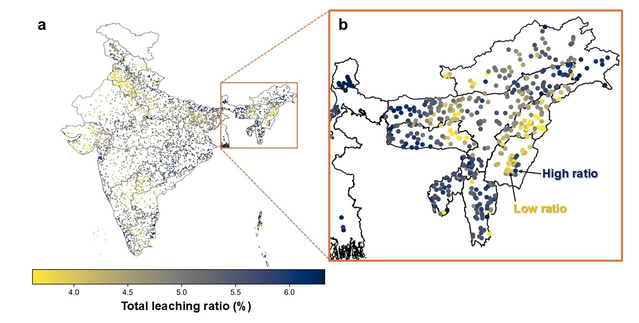
Analyzing pesticide leaching, colored patches can be identified in certain regions (Fig. 1a), indicating geoclimatic hotspots, where pesticides can be accumulated when considering the influence of geoclimatic factors. Moreover, in certain individual locations, there are sudden spikes in pesticide leaching compared to its surrounding dots (Fig. 1b). These patterns showed that pesticide behavior varies across locations due to local geoclimatic conditions as well as farm-level variations.
Identifying of geoclimatic hotspots
Our simulation identified regional hotspots of pesticide accumulation. Notably, potential hotspots are found in several areas with high biodiversity and unique agricultural practices such as organic farming regions. For example, Sikkim emerged as a hotspot with exceptionally high pesticide leaching ratios (Fig. 2, Area w). Since its designation as an “Organic State” in January 2016, pesticide application has ceased in Sikkim. Further studies are recommended to assess residual leaching from past pesticide applications.
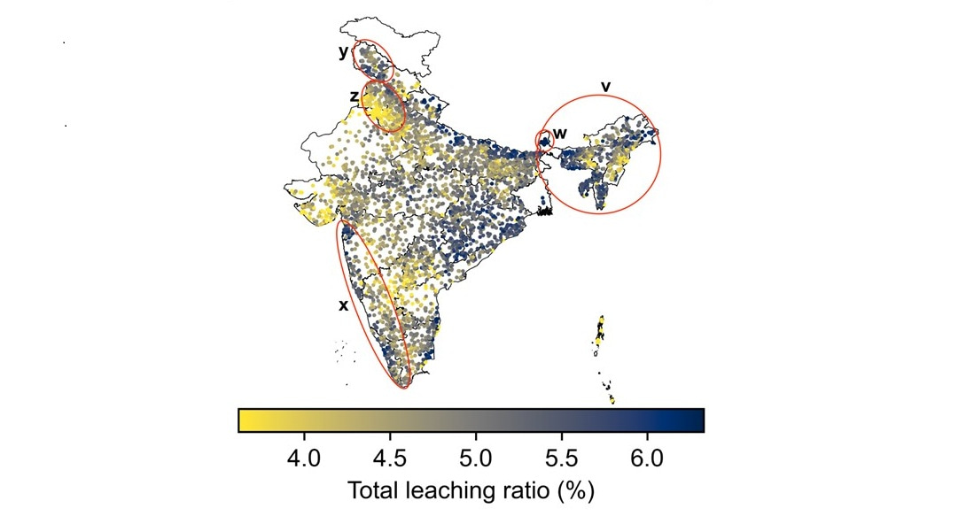
Fig 2: Potential pesticide leaching ratio pattern. Selected areas of concern based on leaching ratio, agricultural practice, and biodiversity are shown; (v) The northeast part of India, (w) Sikkim, (x) Western Ghat region, (y) Panjab-Haryana, (z) Jammu & Kashmir.
Another example is Western Ghats region, located along the western coast of India (Fig. 2, Area x). As the map shows, this region also exhibited a higher pesticide leaching trend. The region has a diverse biodiversity and is known for its plant-based products, including spices and medicinal plants. These examples emphasize the need for localized guidelines in pesticide regulation and management that account for both region-specific and farm-level conditions.
Empowering Farmers with Data
Using India as a case study, this study showcased the potential of fine-scale geoclimatic simulation in pesticide management by offering actionable, location-specific insights. However, further exploration is necessary. Future research will concentrate on incorporating a wider array of pesticide compounds, exploring other geographical locations, and conducting experimental validations to refine and calibrate the model.
Moving forward, we plan to develop an interactive user interface that will empower farmers, agronomists, and policymakers to simulate pesticide accumulation (dynamics) based on their farm data. Using the tool, they can select pesticides with minimal environmental impact and optimize pesticide application rates across regions, based on specific local conditions. By integrating advanced modeling techniques into practical agricultural decision-making, we wish to make a modest contribution to promoting sustainable agricultural practices and transitioning to nature-positive crop production, helping humanity to operate within the safe limits of planetary boundaries.
Follow the Topic
-
Scientific Data

A peer-reviewed, open-access journal for descriptions of datasets, and research that advances the sharing and reuse of scientific data.
-
Scientific Reports

An open access journal publishing original research from across all areas of the natural sciences, psychology, medicine and engineering.
Related Collections
With Collections, you can get published faster and increase your visibility.
Obesity
Publishing Model: Hybrid
Deadline: Apr 24, 2026
Data to support drug discovery
Publishing Model: Open Access
Deadline: Apr 22, 2026


Please sign in or register for FREE
If you are a registered user on Research Communities by Springer Nature, please sign in