Separating position and intensity in the palaeoclimate record
Published in Earth & Environment


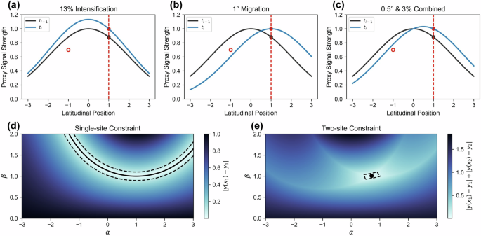

The stability of the global climate is fundamentally dependent on climate circulation patterns. Ocean currents transport heat and freshwater across the globe. Atmospheric wind belts carry heat and moisture, shaping rainfall patterns. Changes in these patterns can have serious ramifications for local climates, ecosystems, and human societies. Thus, understanding how they will respond to ongoing anthropogenic climate change is vital. To predict future changes, we must look for evidence in the past of how these circulation features respond to external forcing. However, there is a fundamental challenge: did a reconstructed change arise from a change in circulation strength, or did it simply move?
A useful analogy for this problem is to liken the circulation feature to a torch pointing at you, the proxy archive. Increasing the brightness of the torch or pointing it more directly at you would both cause you to detect a brightening. This indistinguishability is what we call proxy signal conflation (Fig. 1).
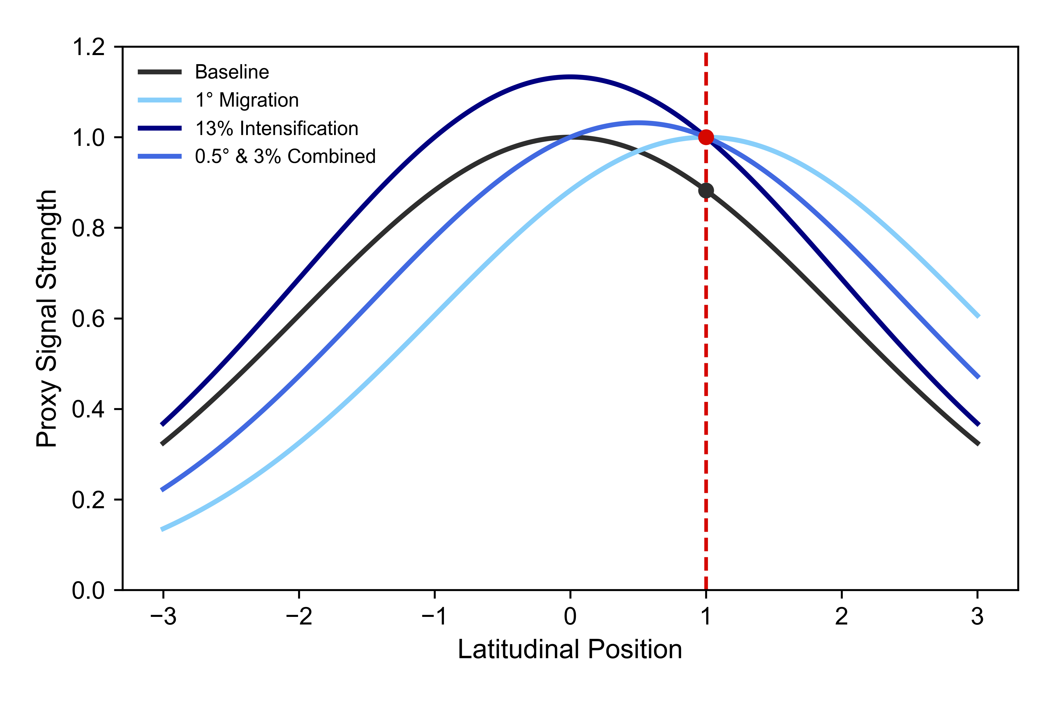
Figure 1: A schematic showing proxy signal conflation given a single site. A reconstructed change (from the black circle to the red circle) could be explained by infinitely many profile changes, including: (1) 1° migration, light blue line; (2) 13% intensification, dark blue line; or (3) a 0.5° migration with a 3% intensification, blue line. Figure modified from Forman et al., 2026 (https://doi.org/10.1038/s43247-026-04134-2). The header image is a map of ERA5 reanalysis surface (10 m) wind speed (1940-2026 mean; https://doi.org/10.24381/cds.f17050d7).
Separating these effects is essential because incorrectly interpreting one change for another can lead to inaccurate reconstructions of the past. This could have knock-on effects to how well we understand what changes are going to occur in the future.
Our new study (see Forman et al., 2026 – https://doi.org/10.1038/s43247-026-04134-2) introduces this problem and explores it by asking how previous studies have managed to disentangle these two modes of variability. We examine three major subsystems where this challenge has emerged: the Gulf Stream, the Intertropical Convergence Zone (ITCZ), and the Southern Westerly Winds (SWW). Our analysis finds three widely used approaches: (1) spatial networks, (2) dimension-specific proxies, and (3) proxy-model comparisons.
While a single record tells us what happened at a specific location, a spatial network can represent the circulation system more accurately as it leverages more evidence. Records distributed across the circulation feature showing contrasting changes can be evidence that a feature has moved rather than simply strengthened/weakened. Networks can therefore reveal spatial information that is difficult to obtain from a single site.
Another approach is to use dimension-specific proxies. Different palaeoclimate indicators respond to different aspects of the climate system. Using this knowledge in combination with additional information about constraints on the proxy’s variability can therefore lead to robust arguments that a record is capturing exclusively intensity or position.
While these are rare and require significant validation, one example is the use of ocean current transport proxies with physical constraints on the current’s position. Measuring the strength of a current at a point where its position is dictated by geography means that the proxy purely captures intensity change.
Finally, proxy-model comparisons have also been used to mitigate the effects of conflation. Here, researchers use emergent relationships from climate model simulations to determine the mode of variability being seen in the palaeo-record. This allows for a physics-based constraint, which can circumvent the need for additional sites.
By incorporating this interpretation challenge into study design, we can better reconstruct past changes in climate circulation and in so doing improve our understanding of future climate change.
Follow the Topic
-
Communications Earth & Environment
An open access journal from Nature Portfolio that publishes high-quality research, reviews and commentary in the Earth, environmental and planetary sciences.