The Arctic’s overlooked small rivers are reshaping land-ocean sediment flux
Published in Earth & Environment and Sustainability
Our team has long been interested in how climate change reshapes water and sediment fluxes in cold regions. Much of this work has focused on the High Mountain Asia, where we observed exceptional increases in fluvial sediment flux under a warmer and wetter climate. These findings brought us back to a broader and more fundamental question: if warming can so strongly reorganize erosion, runoff and sediment delivery in one cold region, what might be occurring in the Arctic?
At first glance, the pan-Arctic and the Tibetan Plateau appear fundamentally different. One is a vast high-latitude landscape shaped by permafrost, low relief and tundra; whereas the other is a high mountain system characterized by steep slopes and glaciers. Yet, they share several essential traits: both are climate-sensitive cold regions, both are strongly influenced by frozen ground and ice, and both are undergoing rapid change. Previous studies have shown that some major Arctic rivers are transporting increasing amounts of sediment. However, we felt that the time had come to move beyond these individual cases, because the Arctic contains far too many rivers for its sediment dynamics to be understood through only a handful of well-studied systems.
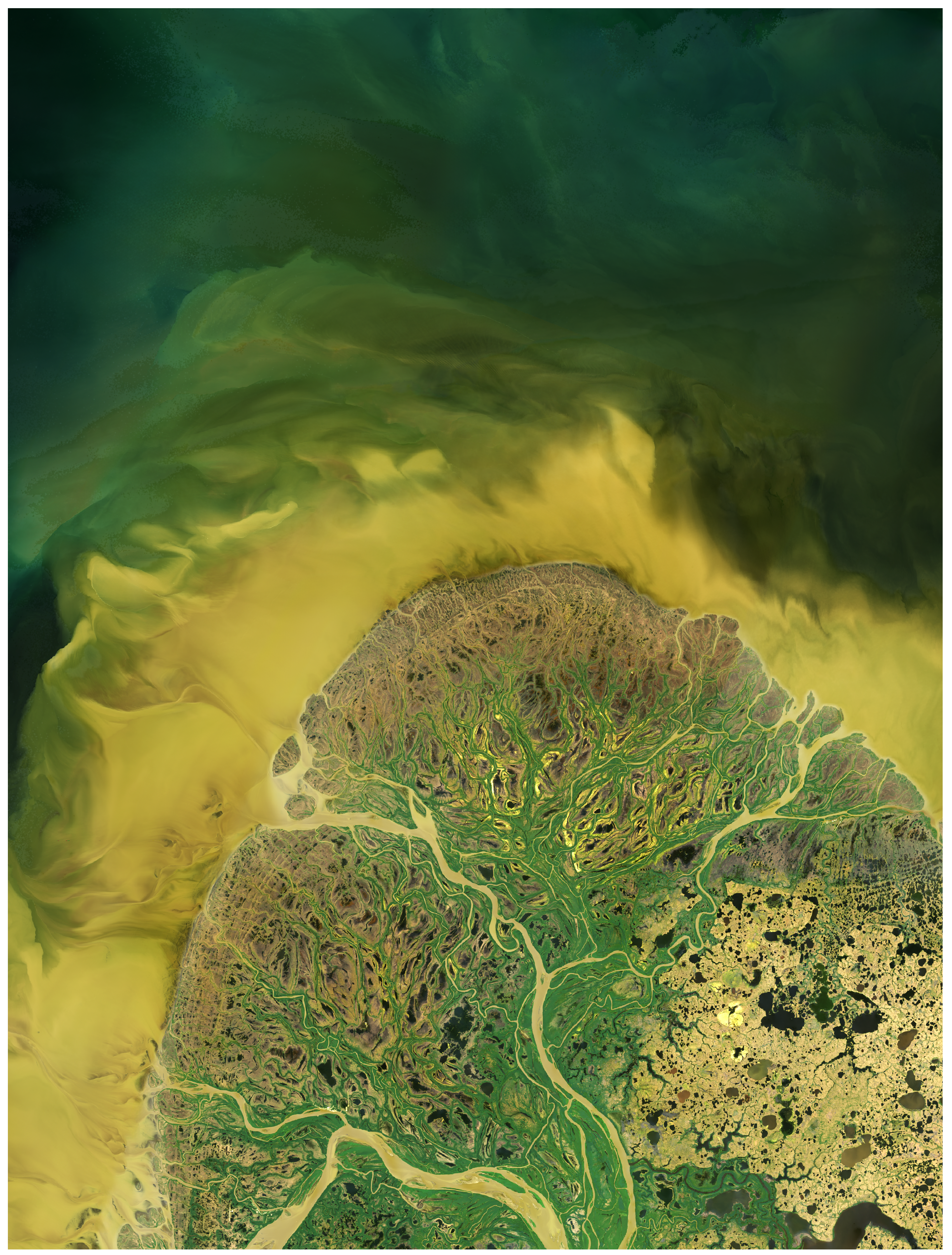
That ambition quickly encountered the Arctic’s greatest constraint: data availability. The pan-Arctic remains one of the most data-sparse regions on Earth for river sediment observations. More than 99% of coastal pan-Arctic rivers drain small, ungauged basins, and many lack long-term field measurements. Yet these rivers are often the most directly exposed to rapid warming, permafrost thaw and shifting runoff regimes. How can sediment dynamics be reconstructed across an entire Arctic river network when so much of that network remains largely unmonitored?
The only realistic option was remote sensing. Satellites can capture environmental change from space, including in regions that are remote, inaccessible, and logistically challenging. However, as we began working more closely on Arctic rivers, it became clear that the Arctic is also a uniquely difficult environment for satellite-based retrieval of suspended sediment concentration (SSC). Most pan-Arctic rivers have relatively low SSC, and their optical signals are easily obscured by cloud, seasonal snow, river ice and short open-water periods. Even the identification of valid river pixels is not straightforward. These conditions make simple empirical algorithms appealing, but at the same time constrain their applicability.
This became the core methodological challenge of our study. We aimed to move beyond traditional empirical approaches and develop a novel framework specifically designed for the Arctic. This led to Arctic-SRT, the pan-Arctic-river Sediment Retrieval Technique. We combined 80,232 Landsat images with multi-modal machine learning to better capture the nonlinear relationship between SSC and satellite signals. Importantly, we introduced a two-step strategy to reduce interference from cloud, snow and river ice. We first combined multiple water extraction methods and retained only pixels where they agreed, and then applied a pan-Arctic-specific reflectance threshold to further remove residual snow- and ice-related misclassification. We then reconstructed monthly, reach-scale SSC for 4,331 river reaches over nearly four decades, including many small rivers that were previously almost invisible.
Before conducting the full analysis, we already suspected that Arctic rivers might be transporting more sediment under a warming climate. The physical basis for this expectation was straightforward. The Arctic is warming nearly four times faster than the global average, river discharge has increased, and climate-driven changes such as glacier melt, permafrost disturbance, shifts in snowfall and increasing fire activity are altering erosion and hydrological connectivity. In principle, these changes should facilitate the transfer of terrestrial sediment to rivers and ultimately to the ocean.
Still, the results surprised us.
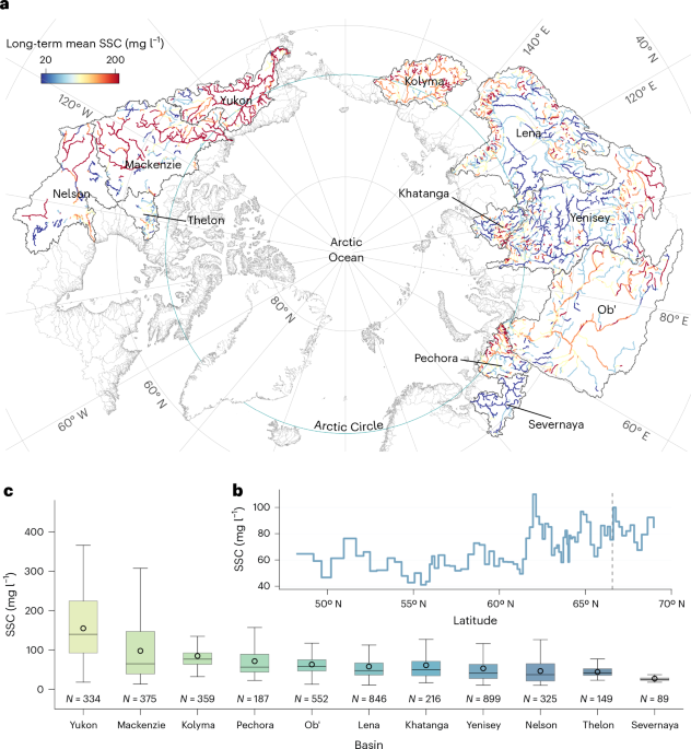
In the continuous permafrost zone, about 40% of river reaches showed significant increases in SSC, primarily associated with increasing discharge, intensified thermokarst disturbances and fire activity. In this sense, Arctic rivers are indeed becoming muddier. However, the most unexpected result was not simply the overall increase in sediment. It was which rivers were driving that increase.
Like many others, we initially assumed that the six major Arctic rivers would dominate both the total sediment flux and its temporal trend. They do dominate the total amount, contributing 198 Mt yr−1, or 63% of the pan-Arctic land–ocean sediment flux. But once the many smaller rivers were accounted for, a very different picture emerged. We found that 263 previously overlooked small- and medium-sized coastal rivers together contribute 117 Mt yr−1, or 37% of the total. Even more strikingly, their flux increase rate is about five times higher than that of the six major rivers. In other words, the recent increase in total pan-Arctic sediment flux is not primarily a big-river signal. It is driven largely by the smaller coastal rivers that have long been overlooked.
Why are these smaller rivers changing so quickly? Part of the answer is that they are fundamentally different systems. Many lies at higher latitudes, are more strongly associated with permafrost-dominated tundra, and are characterized by widespread ice-wedge polygon terrain, limited sediment storage in floodplains, and more direct connections to the ocean. These small coastal basins have also warmed about twice as fast as the six major basins, likely amplifying thermokarst erosion, sediment supply and hydrological connectivity. Faster increases in discharge then transfer of this additional sediment to the coast.
This finding changed the way we think about Arctic river systems. Focusing only at the major rivers means overlooking the fastest-changing component of the river network. More broadly, it also highlights a fundamental contrast with other cold regions. In mountain systems such as the Tibetan Plateau, strong sediment responses are often linked to steep relief and high erosion potential across major alpine rivers. In the pan-Arctic, by contrast, large rivers typically drain lower-relief basins with more resistant lithologies and generally lower background SSC. As a result, the clearest signal of change is not that all the major rivers are getting much muddier, but rather that smaller, more climate-sensitive coastal rivers are rapidly reshaping the Arctic sediment budget.
In the end, our work is about more than river sediment. It is about what becomes visible when we move beyond the Arctic’s biggest rivers. As the Arctic warms, increasing amounts of sediment are being transferred from land to ocean, with important implications for coastal stability, delta evolution, nutrient transport and carbon cycling. Perhaps the clearest message from our study is also the simplest: rivers always tell, but the ones we overlook often tell the most.
Further details are available in our paper published in Nature Geoscience:
Follow the Topic
-
Nature Geoscience
A monthly multi-disciplinary journal aimed at bringing together top-quality research across the entire spectrum of the Earth Sciences along with relevant work in related areas.

What are SDG Topics?
An introduction to Sustainable Development Goals (SDGs) Topics and their role in highlighting sustainable development research.
Continue reading announcement


Please sign in or register for FREE
If you are a registered user on Research Communities by Springer Nature, please sign in