The Hidden Technology Behind Smarter and More Secure Spatial Systems
Published in Earth & Environment, Electrical & Electronic Engineering, and Physics
Cybersecurity Is Becoming Spatial
Every intrusion alert, GPS coordinate, surveillance event, drone trajectory, environmental sensor, or emergency response request contains a spatial dimension. Behind these applications lies an often-overlooked challenge: how can massive amounts of spatial data be searched, organized, and retrieved quickly enough to support real-time decision-making?
As our world becomes increasingly connected, answering this question is becoming just as important as protecting the systems themselves.
This challenge motivated our latest research.
When Traditional Spatial Indexes Reach Their Limits
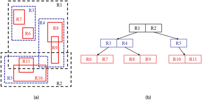
For decades, the R-tree has been one of the most widely used spatial indexing data structures. It enables efficient searching of multidimensional data and serves as a fundamental building block for geographic information systems (GIS), navigation platforms, mapping services, environmental monitoring, and many location-based applications.
However, modern applications generate data at an unprecedented scale. Smart cities continuously stream sensor information, autonomous vehicles update their positions every fraction of a second, and large IoT deployments produce dynamic spatial datasets that are constantly changing.
Under these conditions, traditional R-tree structures begin to struggle. As new data are inserted and removed, the tree becomes increasingly unbalanced, while overlapping search regions force queries to explore unnecessary branches. The result is slower query processing and less efficient use of storage resources.
Improving the efficiency of spatial indexing is therefore not simply a database optimization problem—it directly influences the responsiveness of many intelligent and security-critical systems.
Learning from Nature
Instead of relying on fixed heuristics, we asked a simple question:
Could nature provide a better way to organize spatial information?
Particle Swarm Optimization (PSO), inspired by the collective behavior of bird flocks and fish schools, offers an elegant approach to solving complex optimization problems. Rather than following predetermined rules, a swarm of particles collaboratively searches for increasingly better solutions by continuously learning from both individual and collective experience.
We believed that these characteristics made PSO an excellent candidate for dynamically optimizing the internal structure of R-trees.
Building an Adaptive Spatial Index
This idea led us to develop PSO-RT, an adaptive framework that integrates Particle Swarm Optimization directly into the R-tree structure.
Instead of performing traditional node splitting and merging operations, the proposed framework continuously searches for better structural configurations that reduce overlap between minimum bounding rectangles (MBRs), maintain a balanced tree structure, and improve storage utilization.
To evaluate the framework, we conducted extensive experiments across three datasets: synthetic spatial data, OpenStreetMap, and TIGER geographic datasets. These datasets exhibit different spatial distributions and levels of complexity, enabling us to evaluate scalability and robustness under realistic conditions.
What Surprised Us
One of the most encouraging outcomes was the consistency of the improvements across all datasets.
PSO-RT cut query response time by up to 35.7%, cut the amount of overlap between bounding rectangles by 42.7%, and improved node utilization by 19.6% compared to regular R-tree implementations. These improvements translated into faster searches and more efficient use of storage resources across diverse spatial environments.
Like many optimization techniques, PSO introduces additional computational overhead during insertion and deletion operations. However, this cost is compensated by significantly faster query execution—the operation is performed far more frequently in most real-world applications. This trade-off highlights an important engineering principle: optimizing the right part of the system often delivers the greatest overall benefit.
Why This Matters for Cybersecurity
Although our research focuses on spatial indexing, its implications extend well beyond database performance.
Modern cybersecurity increasingly depends on processing location-aware information. Threat intelligence platforms analyze geographically distributed events. Smart city security systems monitor spatial patterns in real time. Autonomous vehicles continuously evaluate nearby objects. Critical infrastructure operators correlate alerts from geographically dispersed assets.
All of these applications depend on efficient spatial data management.
By making spatial indexing faster, more adaptive, and more scalable, we provide a foundational technology that can support future cybersecurity, cyber-physical, and intelligent infrastructure applications.
Sometimes, the technologies that have the greatest impact on security are those that work quietly behind the scenes.
Looking Ahead
As spatial data continues to grow exponentially, efficient indexing will become even more important. Future intelligent systems will require indexing structures that are not only faster but also adaptive enough to respond to continuously changing environments.
Combining optimization algorithms with classical data structures offers exciting opportunities to build the next generation of intelligent spatial databases.
For us, this work is another step toward developing smarter computational foundations that can support secure, scalable, and data-intensive applications across cybersecurity, artificial intelligence, and smart infrastructure.
Final Thoughts
As cyber-physical systems become increasingly connected, efficient spatial data management is becoming a critical enabler of both intelligence and applications. Our goal with this research was to demonstrate that nature-inspired optimization can make spatial indexing more adaptive, scalable, and practical for real-world environments.
We are excited to continue exploring intelligent optimization techniques that strengthen the computational foundations of next-generation, secure, data-driven systems.
Published article
Enhancing R-tree Spatial Indexing Using an Adaptive Particle Swarm Optimization Algorithm
Discover Informatics (2026)
Dr. Qasem Abu Al-Haija is Chair of the Cybersecurity Department at Jordan University of Science & Technology (JUST), Irbid, Jordan. He received his Ph.D. in Computer Engineering from Tennessee State University (USA). He has been recognized as one of Stanford/Elsevier’s Top 2% Scientists worldwide (2023–2025). Dr. Abu Al-Haija has authored and co-authored more than 300 scientific publications, including journal articles, conference papers, books, and book chapters. His research interests span cybersecurity, artificial intelligence, Internet of Things (IoT), cyber-physical systems (CPS), machine learning, cryptography, smart systems, and secure digital transformation. He serves as a guest editor, reviewer, keynote speaker, technical program committee member, and organizer for international journals and conferences in AI and cybersecurity.
Follow the Topic
-
Discover Informatics
This is an open access journal publishing research from all fields relevant to informatics.

Related Collections
With Collections, you can get published faster and increase your visibility.
Generative AI and Next-Generation Machine Vision: Architectures, Applications, and Interdisciplinary Frontiers
The rapid evolution of Generative AI (GenAI) and Large Vision Models (LVMs) is fundamentally reshaping the landscape of Machine Vision. While traditional machine vision focuses on discriminative tasks such as classification and detection, the integration of generative techniques—including Diffusion Models, Variational Autoencoders (VAEs), and Generative Adversarial Networks (GANs)—enables systems to synthesize high-fidelity data, perform complex image-to-image translations, and enhance visual understanding in low-resource environments.
This Collection seeks to explore the synergy between GenAI and Machine Vision across various domains. We invite original research and review articles that address theoretical breakthroughs and practical implementations. Key areas of interest include, but are not limited to:
- Synthetic Data Generation: Utilizing GenAI to mitigate data scarcity in specialized fields like underwater imaging, medical diagnostics (e.g., surgical assistance), and rare defect detection in smart manufacturing.
- Vision-Language Models (VLMs): Leveraging multimodal generative frameworks to improve robot perception and human-robot interaction.
- Image Enhancement & Restoration: Advanced generative approaches for dehazing, super-resolution, and noise reduction in challenging environments.
- Trustworthy AI: Addressing the robustness, explainability, and ethical implications of generative models in critical vision-based decision-making.
By bridging the gap between "creating" and "seeing," this Collection aims to define the next paradigm of intelligent visual systems.
This Collection supports and amplifies research related to: SDG 9.
Publishing Model: Open Access
Deadline: Feb 21, 2027
Trustworthy Human-AI Systems: Governance, Explainability, Interoperability, and Accessible Intelligent Ecosystems
Transparency plays a central enabling role in identifying, mitigating, and reasoning about a broad spectrum of legal, ethical, and governance risks arising across the AI lifecycle, from data collection and model development to deployment and post-market monitoring. However, transparency cannot be reduced to a single, universal requirement: it is inherently context-dependent, defined at multiple technical and organizational layers (data, model, interface, process, and governance) and calibrated to distinct objectives and stakeholder needs.
We propose a high-impact, technically rigorous manuscript positioned as the engineering playbook for deploying AI in complex ecosystems: how to build interoperable, accessible, and audit-ready Human–AI systems that meet regulatory and ethical constraints while delivering measurable value in smart cities, Industry 4.0, healthcare, and financial services. The core market gap is clear: principles are abundant, but deployable architectures, controls, and evaluation methods remain fragmented across disciplines such as software architecture, privacy engineering, and AI governance.
The Collection will package a unified, implementation-first frameworks spanning: system interoperability (semantic alignment, data contracts, standard conformance, API/event architectures, observability); accessibility and inclusive design; adaptive interfaces and intelligent systems (context-aware personalization, uncertainty-aware interaction, safe automation boundaries); and Human–AI collaboration & explainability (task-level explanations, calibrated confidence, contestability, human-in-the-loop protocols). These capabilities are anchored in ethics, privacy, and trust in informatics: privacy-by-design and regulatory compliance translated into enforceable controls, plus ethical AI methods and trust engineering.
We welcome contributions that address this challenge around the following topics:
- Human–AI Collaboration Patterns
- Innovative methodologies for designing transparent AI systems for meeting stakeholder needs
- Citizen-Facing Human–AI Services
- Human–AI for Operations optimization & Safety
- Trust Engineering: Auditability by Default
- Ethical AI Engineering in Practice
- Governance for Digital Transformation
- Tools, metrics, and techniques for monitoring and ensuring transparency in AI
- Transparency risk assessments
- Workforce Upskilling for Trustworthy AI
- Participatory design and co-creation methodological approaches
- Case studies and best practices for transparent AI in real-world applications
- Legal transparency requirements
Contributors will deliver reference architectures, control catalogs, metrics, checklists, and real deployment case studies, turning trustworthy AI from an aspiration into a repeatable, scalable practice.
This Collection supports and amplifies research related to: SDG 4, SDG 9, and SDG 11.
Publishing Model: Open Access
Deadline: Jan 31, 2027
Please sign in or register for FREE
If you are a registered user on Research Communities by Springer Nature, please sign in