What Flight Data Reveals About Hidden Carbon Efficiency in Aviation — And Why It Matters
Published in Social Sciences, Earth & Environment, and Business & Management



What Flight Data Reveals About Hidden Carbon Efficiency in Aviation — And Why It Matters
Aviation is under growing pressure to reduce its carbon footprint. As global air travel expands, emissions continue to rise, making sustainability an urgent priority. Most discussions focus on technological solutions such as more efficient aircraft or alternative fuels. However, an important part of the solution may already exist in how flights are operated today.
What if a significant part of carbon reduction in aviation depends not on future technology, but on how we operate flights today?
Looking at What We Already Have
The aviation industry has invested heavily in improving aircraft technology. However, technological transitions take time, require large investments, and depend on global coordination. At the same time, thousands of flights operate every day under existing conditions.
This raises an important question:
Are we using current systems as efficiently as possible?
Most studies examine emissions at a macro level, focusing on airlines, countries, or global trends. In contrast, my research focuses on the operational level—how flight activity at a single airport can reveal patterns of carbon efficiency.
Building a Data-Driven Model
To explore this, I combined two sources of publicly available data:
- Flight observations collected from FlightRadar24
- CO₂ efficiency scores from the Atmosfair Airline Index
My aim was to directly link operational decisions—such as flight frequency and load—with carbon efficiency, demonstrating the significant role these factors play, independent of new technology.
I focused on two key variables:
- Total payload (how much weight an aircraft carries)
- Daily landing frequency (how often it operates)
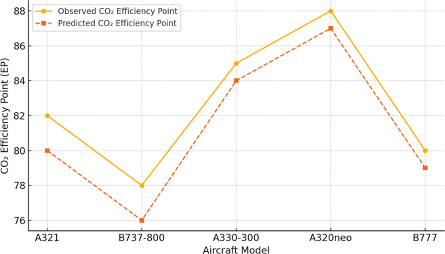
Using these inputs, I developed a machine learning model to predict CO₂ efficiency scores.
What the Results Show
The findings were both clear and surprising.
The model explained a large share of the variation in CO₂ efficiency using only these two variables. This means that operational factors—things that can be adjusted without new technology—play a significant role in environmental performance.
More specifically, the results suggest:
- Aircraft carrying more passengers and cargo tend to be more efficient
- Higher operational intensity can improve efficiency under certain conditions
This leads to an important conclusion:
Carbon efficiency is not only determined by technology, but also by how existing systems are used.
Why This Matters
These findings have several important implications.
First, improving sustainability does not always require waiting for future innovations. Better operational decisions—such as optimizing flight frequency and capacity—can already lead to meaningful improvements.
Second, they highlight the importance of data-driven approaches. By using existing operational data, airlines and airports can better understand where inefficiencies occur and how to address them.
Third, this research supports broader global goals. Organizations such as the International Civil Aviation Organization (ICAO) emphasize that reaching net-zero emissions requires not only technological innovation but also smarter operational strategies.
Challenges Behind the Research
One of the main challenges of this study was data collection. The dataset was relatively small and required manual observation. In addition, only a limited number of variables could be included in the model.
Despite these limitations, the results were consistent and meaningful. This suggests that even simple models, when applied carefully, can provide valuable insights.
This was also a key lesson from the research process:
You do not always need complex systems to uncover important patterns—sometimes, the right question is enough.
Looking Forward
This study is only a starting point. Future research can expand the model by including additional variables such as flight distance, aircraft age, or fuel type. It can also be applied to other airports to test whether similar patterns exist.
Another promising direction is integrating such models into real-time decision systems. Airports and airlines could use data-driven tools to monitor efficiency and dynamically adjust operations.
Final Thoughts
Aviation sustainability is not only a technological challenge. This study’s central finding is that operational improvements, applied to current fleets and systems, offer meaningful—and often overlooked—paths to lower emissions.
By combining real flight data with simple machine learning techniques, it is possible to uncover hidden patterns in carbon efficiency. These insights can support better decision-making and contribute to more sustainable aviation practices.
The path to greener aviation is not only about the technologies we develop in the future, but also about how effectively we use the systems we already have.

I am an academic researcher at Magdeburg-Stendal University of Applied Sciences, specializing at the intersection of environmental sustainability, transport systems, and data-driven analysis. My research primarily addresses environmental and CO₂ efficiency, with a particular emphasis on the aviation and transport sectors, employing machine learning and applied quantitative methods. I am interested in exploring how advanced analytics can support evidence-based policy, sustainability governance, and real-world decision-making.
More broadly, my work is driven by the aim of translating complex data into insights that are accessible to policymakers, practitioners, and a wider audience concerned with climate and sustainability challenges.
Follow the Topic
-
Discover Environment
This is a transdisciplinary, open-access journal that provides a leading platform for the rapid dissemination of knowledge and advances covering the research and innovation that is taking place across the environmental sector.

Related Collections
With Collections, you can get published faster and increase your visibility.
Mapping Sustainability: Geospatial Tools for Environmental Challenges
The escalating complexity of global ecological challenges demands innovative approaches to understanding, monitoring, and managing the environment. Geospatial technologies, including Geographic Information Systems (GIS), remote sensing, and spatial analytics, have become indispensable tools in addressing these issues. These technologies have demonstrated remarkable impact across various domains. For instance, in disaster management, the NASA-Disaster Response Coordination System utilizes satellite imagery and GIS analytics to assess damages from natural calamities, while the Copernicus Emergency Management Service (EMS) provides real-time mapping and early warning systems. In biodiversity conservation, initiatives like Global Forest Watch (GFW) and the Integrated Biodiversity Assessment Tool (IBAT) employ satellite data and spatial datasets to monitor deforestation and support conservation planning. Additionally, in urban sustainability, projects such as the Landsat Urban Heat Mapping Initiative help urban planners mitigate rising temperatures through targeted green infrastructure solutions.
This collection, "Mapping Sustainability: Geospatial Tools for Environmental Challenges," addresses critical gaps in the current literature by showcasing pioneering research that leverages geospatial technologies to confront urgent environmental issues. While existing research extensively explores geospatial methods, there is a significant need for more integrated, interdisciplinary approaches that translate data-driven insights into actionable solutions for sustainability. This collection advances the field by bridging science and policy, enhancing urban sustainability, advancing climate resilience, promoting data-driven conservation, and innovating spatial decision support systems (SDSS). Contributions that emphasize interdisciplinary research, innovative case studies, global perspectives, and policy insights are highly encouraged.
Keywords:Geospatial Technologies; Environmental Sustainability; Climate Change Analysis; Biodiversity Conservation; Pollution Monitoring; Water Resource Management; Spatial Data Analytics; Sustainable Development; Ecological Resilience; Geospatial Modeling; Spatial Decision Support Systems (SDSS); Remote Sensing Applications; Sustainable Urban Planning; Land Use and Land Cover Change (LULC); Disaster Risk Reduction (DRR); Ecosystem Monitoring; GIS-based Policy Analysis; Smart Cities and Resilient Infrastructure
Publishing Model: Open Access
Deadline: Jan 31, 2027
Monitoring environmental pollution and impact on health
The intensification of human activities and the expansion and densification of urban areas cause various damages to the environment, necessitating continuous monitoring to assess the impact and extent of potential risks to both the environment and human health, in order to ensure urban sustainability.
This collection, “Monitoring Environmental Pollution and Impact on Health,” invites contributions that utilize tools related to health impact assessment, human health risk, ecological risk, data modeling, geospatial data, and Geographic Information Systems (GIS) to analyze impacts within urban environments. We also encourage the publication of research on the dynamics of pollution and health in rural and peri-urban areas, interdisciplinary studies between environmental sciences and public health, epidemiology, and urban planning for a holistic assessment of the multifaceted impacts of pollution on human well-being. In addition, studies that contribute actionable policy recommendations for local governments, environmental agencies, or public health institutions dealing with urban pollution are welcome. Research (time series or longitudinal studies) that demonstrate public health trends related to chronic exposure to pollutants, aiming for a better understanding of long-term urban sustainability issues, are also encouraged. Studies addressing health risks for vulnerable populations (such as children, the elderly, or low-income communities) exposed to environmental pollution in densely populated areas are of particular interest. We welcome studies on participatory monitoring and the development of citizen science, empowering communities to act in collaboration with local environmental health surveillance managers. Research involving satellite pollution monitoring and remote sensing is also encouraged. Comparative studies on pollution and health across different regions, identifying critical hotspots and globally replicable mitigation strategies, are of interest. We also welcome research that investigates environmental justice and urban socio-demographic inequalities/disparities in health due to environmental pollution. Review studies and meta-analyses exploring trends, methodologies, and gaps in urban environmental health research are also welcome.
Keywords: Health impact assessment, Environmental quality monitoring (air, water, and soil), Pollution sources and emissions, Spatial analysis, Geospatial technology, Climate change, Urban sustainability, Machine learning, Ecological risk assessment, Human health risk assessment
This Collection supports and amplifies research aligned with the following Sustainable Development Goals (SDGs): SDG 11.
Publishing Model: Open Access
Deadline: Feb 28, 2027





Please sign in or register for FREE
If you are a registered user on Research Communities by Springer Nature, please sign in
This post is part of the “Behind the Paper” series for my recent publication in Discover Environment.