Seasonality dominates changes in lake-surface extent and aligns with human residence
Published in Earth & Environment

Lakes are essential components of Earth’s ecosystems and hydrological cycles, influencing biodiversity, climate regulation, water resources, and human livelihoods1. The surface extent—the visible, open-water area—is especially important, as it determines habitat location, influences the transition between inundated and exposed lake beds, and controls overall water storage capacity. However, fully understanding lake dynamics remains challenging due to complex interactions among long-term trends, interannual variability, and seasonal fluctuations. Historically, satellite observations have struggled to capture these dynamics comprehensively, lacking either sufficient temporal frequency or spatial detail2,3. This has resulted in critical gaps in our knowledge of global lake dynamics.
Our team has long been fascinated by the complex dynamics of lakes worldwide. Our research began with extensive field expeditions and satellite analyses, initially focusing on the Tibetan Plateau, where large lakes rapidly expanded in the early 21st century4. Observing contrasting behaviors in different regions—some lakes expanding, others shrinking, and some experiencing pronounced seasonal variability, such as China’s Poyang Lake located in densely populated regions—we sought to answer the key question: “What are the dominant factors shaping lake-surface-extent dynamics at a global scale?”

To answer this question, we leveraged powerful cloud computing platforms, such as Google Earth Engine5, and supercomputing resources at Tsinghua University. Our approach involved deep-learning-based spatiotemporal fusion of two complementary sources of satellite data: MODIS, featuring high temporal frequency but coarse spatial resolution, and the Landsat-derived Global Surface Water (GSW)2 dataset, providing detailed spatial resolution but limited temporal coverage. Specifically, we developed a U-Net model enhanced with a spatial attention mechanism, trained to implement the spatiotemporal fusion and output continuous monthly lake surface extent maps at a fine spatial resolution (30 m).
Our resulting dataset significantly improved upon previous methods, effectively addressing the data gaps inherent in single-source datasets such as the GSW. While GSW had a missing data ratio of around 34% across global lakes, our spatiotemporal fusion method reduced this missing ratio to approximately 1%, delivering nearly complete coverage. Our dataset was validated against the GSW dataset, achieving median user’s and producer’s accuracies of 93% and 96%, respectively. Furthermore, validation with altimetry-based water levels for 47 large lakes on the Tibetan Plateau confirmed the robustness of our results, showing a strong median Spearman correlation coefficient of 0.92. These advances provide an unprecedentedly accurate and temporally consistent global lake-surface-extent dataset, overcoming the longstanding trade-offs between spatial and temporal resolution in satellite observations.
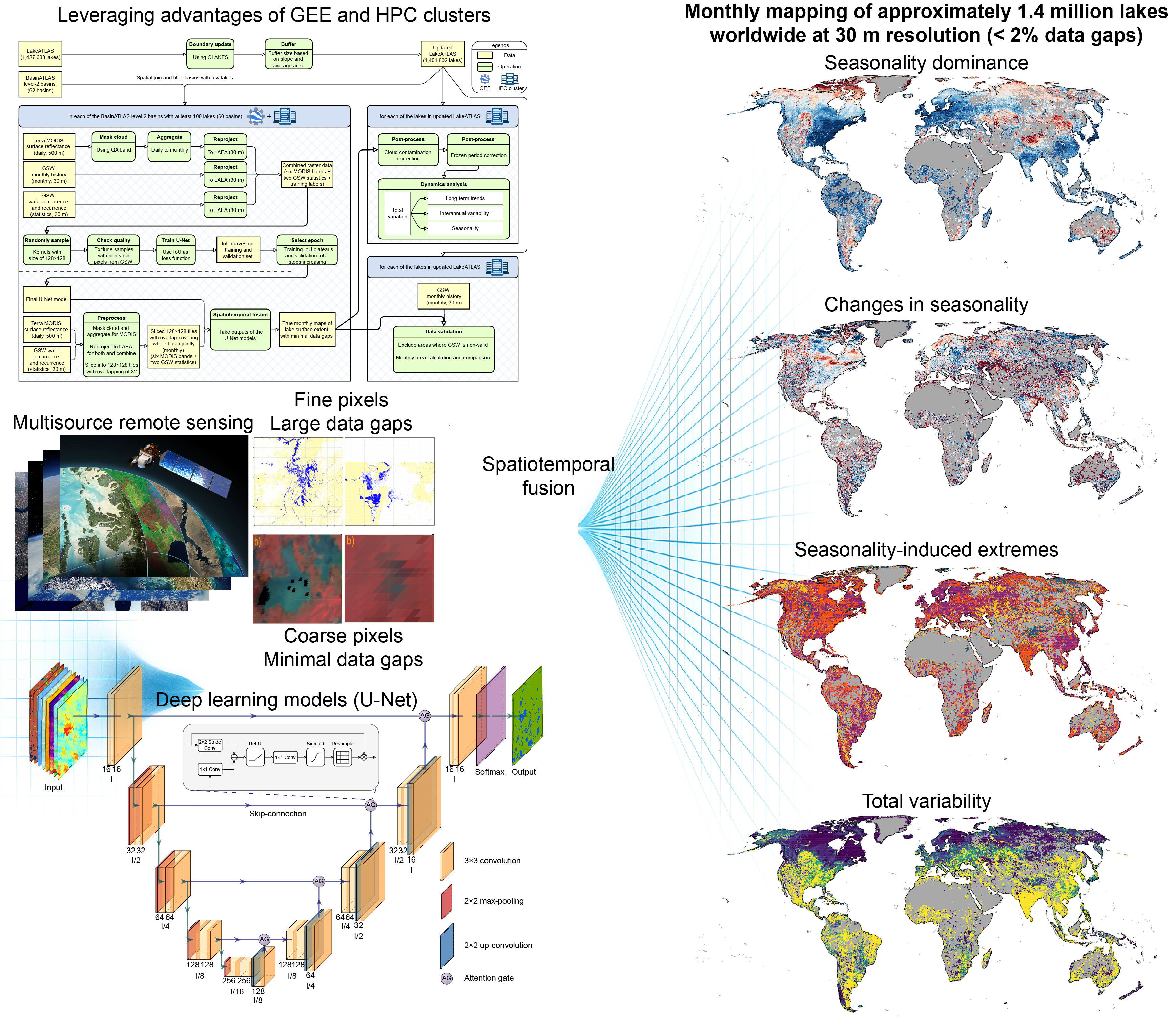
Continuous and high-resolution monitoring of approximately 1.4 million global lakes achieved through deep-learning-based spatiotemporal fusion of multi-source satellite data
Our findings highlight a clear global pattern: seasonality is the primary factor driving lake surface extent dynamics, exceeding the magnitude of long-term trends and interannual variability. Approximately 60% of lakes worldwide, accounting for about 66% of the total lake area, are predominantly influenced by seasonal variations. This seasonal dominance is evident across diverse lake sizes and geographical locations, indicating its fundamental role in shaping lakes’ hydrological and ecological characteristics worldwide.

We also observed a notable spatial correlation between regions where lakes are dominated by seasonal dynamics and areas with high human population densities. More than 90% of the global population resides in basins where more than half of the lakes are dominated by seasonality, and over 50% live in areas where lakes’ seasonality is at least twice as strong as their non-seasonal variations. This relationship emphasizes the important connections between human activities and lake seasonality, highlighting the necessity of effective water resource management and ecosystem protection measures. Additionally, our study identifies substantial impacts of seasonality-induced extremes—short-term yet notable expansions or contractions of lake surfaces—which can significantly intensify or counterbalance long-term changes. Monitoring these extremes is thus crucial for safeguarding ecosystem stability, biodiversity, and sustainable water availability, as well as for climate adaptation planning.
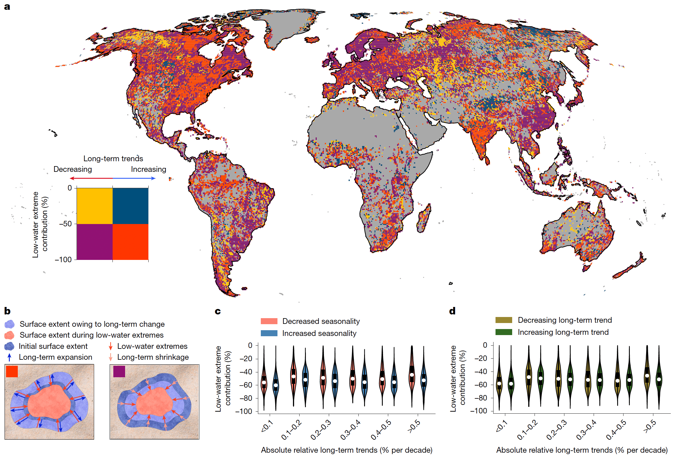
Seasonality-induced low-water extremes amplify long-term lake shrinkage and counteract expansion globally
Looking ahead, there is promising potential for further refinement. Incorporating additional high-quality data, such as monthly ice-cover maps, would enhance model accuracy by allowing it to directly identify frozen conditions, rather than relying on simulation-based postprocessing. Future work should also explore integrating microwave remote-sensing data, which can penetrate vegetation and offer insights into the lake surface under canopy currently obscured in optical imagery6. Perhaps most ambitiously, extending this research to quantify water-storage dynamics, which calls for a higher-quality bathymetry dataset, would provide an even richer understanding of lake dynamics globally, setting the stage for improved ecological management and climate adaptation strategies.
References
- Lehner, B., Messager, M. L., Korver, M. C. & Linke, S. Global hydro-environmental lake characteristics at high spatial resolution. Sci Data 9, 351 (2022).
- Pekel, J.-F., Cottam, A., Gorelick, N. & Belward, A. S. High-resolution mapping of global surface water and its long-term changes. Nature 540, 418–422 (2016).
- Klein, I. et al. Global WaterPack - The development of global surface water over the past 20 years at daily temporal resolution. Sci Data 11, 472 (2024).
- Li, X. et al. High-temporal-resolution water level and storage change data sets for lakes on the Tibetan Plateau during 2000-2017 using multiple altimetric missions and Landsat-derived lake shoreline positions. Earth Syst. Sci. Data 11, 1603–1627 (2019).
- Gorelick, N. et al. Google Earth Engine: Planetary-scale geospatial analysis for everyone. Remote Sensing of Environment 202, 18–27 (2017).
- Prigent, C., Jimenez, C. & Bousquet, P. Satellite-Derived Global Surface Water Extent and Dynamics Over the Last 25 Years (GIEMS-2). Journal of Geophysical Research: Atmospheres 125, e2019JD030711 (2020).
Follow the Topic
-
Nature
A weekly international journal publishing the finest peer-reviewed research in all fields of science and technology on the basis of its originality, importance, interdisciplinary interest, timeliness, accessibility, elegance and surprising conclusions.


Please sign in or register for FREE
If you are a registered user on Research Communities by Springer Nature, please sign in