A hidden fan beneath the East Antarctic Ice Sheet
Published in Earth & Environment
Some research projects begin with a hypothesis. This one began nearly ten years ago, with the recognition of an intriguing pattern hidden beneath the East Antarctic Ice Sheet. Turning that first visual intuition into a tectonic model required years of testing and an interdisciplinary team of Antarctic researchers, bringing together the expertise needed to understand the origin, evolution, and implications on the ice-sheet of this hidden structure.
An intriguing pattern beneath the ice
As we examined increasingly detailed subglacial topography datasets from East Antarctica, we kept noticing the same striking feature: many of the major buried basins, including the Wilkes and Aurora basins, appeared to radiate outward in a systematic way from near the South Pole, almost like the ribs of an opening fan.
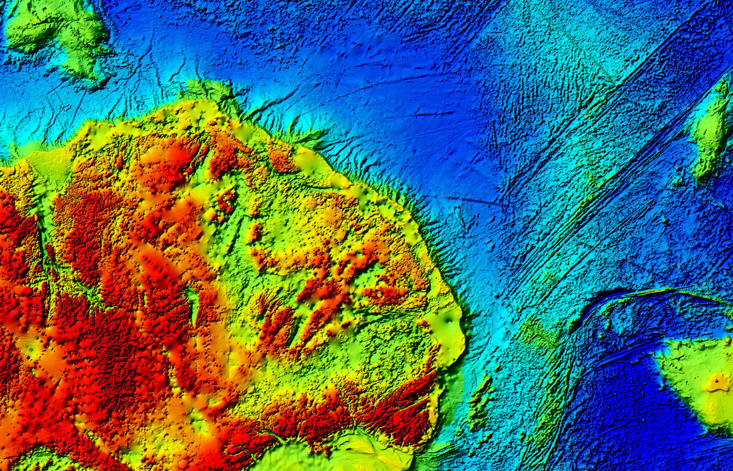
Map of the East Antarctic Fan-shaped Basin Province
The fan extends between the Gamburtsev and the Transantarctic Mountains (source of topography: https://doi.org/10.25921/fd45-gt74 ) and includes several major subglacial basins, such as the Wilkes and Aurora basins, as well as the basin hosting the famous subglacial Lake Vostok. Together, these basins form a radial system of broadly triangular depressions that appear to diverge from a representative pivot point near the South Pole. The fracture zones offsetting the Southeast Indian Ridge in the oceanic domain facing the fan appear to be direct offshore continuations of the main radial structures identified within the continental fan-shaped province.
Even the basin hosting the famous subglacial Lake Vostok appears to be part of this radial system of triangular basins, placing one of Antarctica’s best-known hidden features within a much larger tectonic framework.
Most of these basins also have a distinctly triangular shape, which made the overall geometry even more compelling. We remember being struck by how obvious the pattern seemed once seen at the continental scale, and by the equally striking fact that it had not previously been framed as a single coherent structure.
That first impression was both exciting and unsettling. Exciting, because the geometry seemed too coherent to be accidental. Unsettling, because in Antarctica visual intuition is never enough. More than 99% of the bedrock is hidden beneath the ice, and what appears clear at first glance can easily dissolve under closer scrutiny.
From visual intuition to quantitative analysis
Our first challenge was therefore to test whether this radial pattern was truly there.
To do this, we developed semi-automatic procedures to identify the main topographic lineaments and basin boundaries in the subglacial landscape. This allowed us to move from visual impression to quantitative analysis.
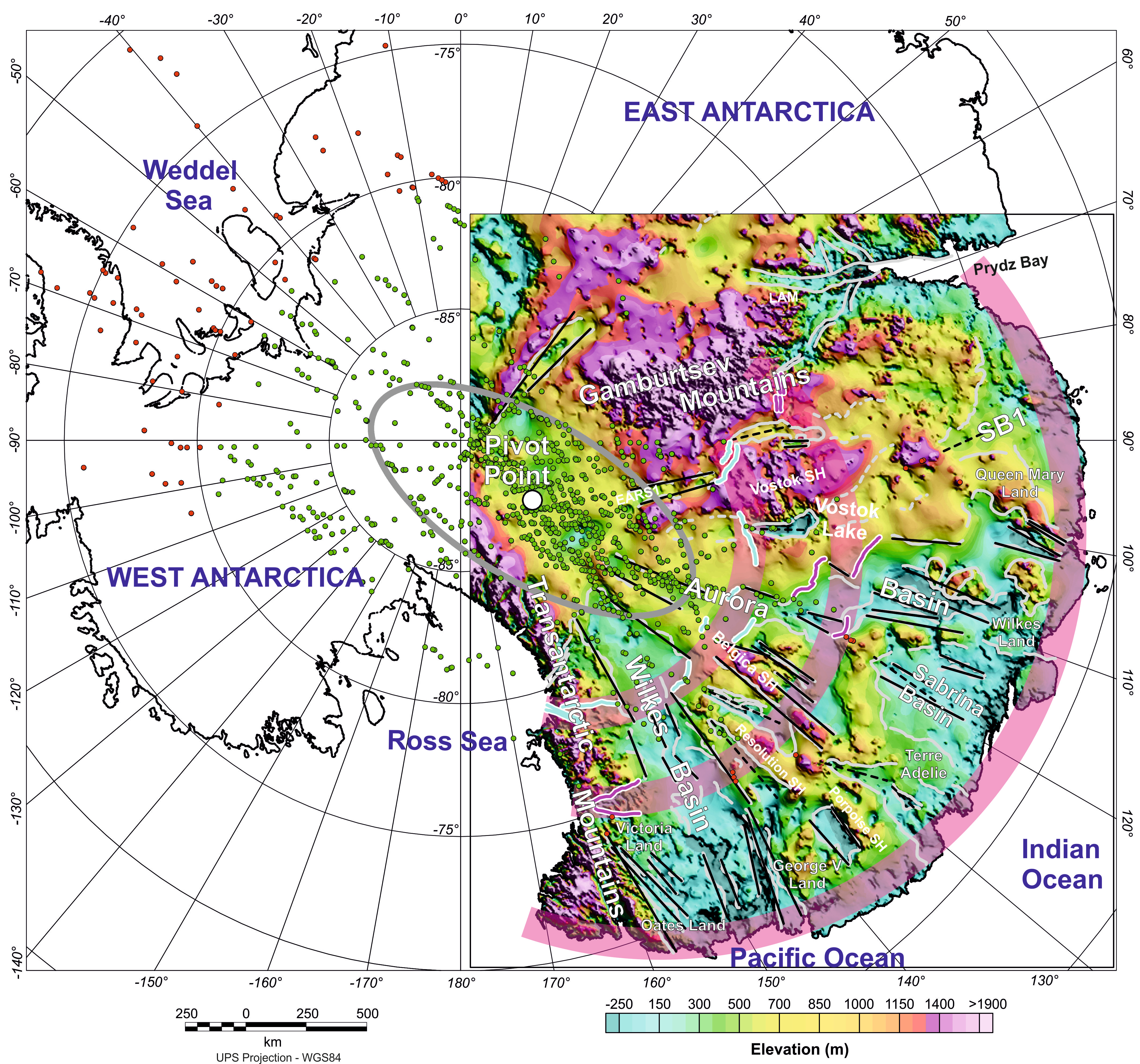
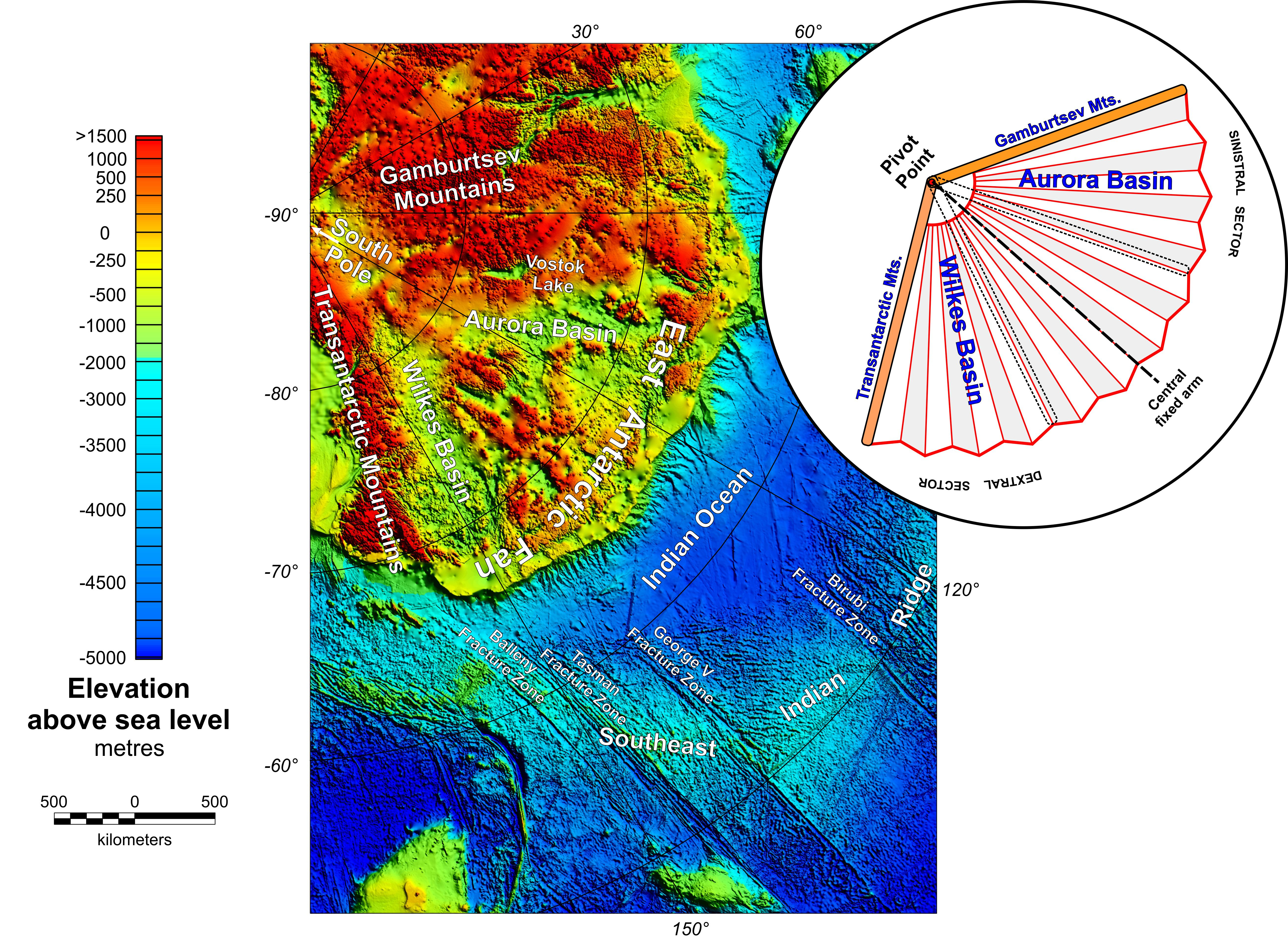
The map shows the main basin boundaries (in gray), interpolated as linear features (in black) to capture the radial geometry of the province, superimposed on the rebounded topography (source: https://doi.org/10.18739/A2280509Z). The green points mark the calculated intersections between these lines, which allowed us to estimate the representative average position of the pivot point organizing the fan-shaped basin system.
That step proved essential. Once the geometry was mapped more rigorously, the pattern held up. The basins were not simply isolated depressions beneath the ice, but part of a much larger fan-shaped physiographic unit extending across a vast sector of East Antarctica.
The analysis also allowed us to estimate a representative average position for the pivot point from which the radial system appears to diverge.
We named this newly identified large-scale physiographic unit the East Antarctic Fan-shaped Basin Province.
Looking deeper into the lithosphere
The next question was whether this was only a landscape feature, or whether it reflected something deeper within the lithosphere.
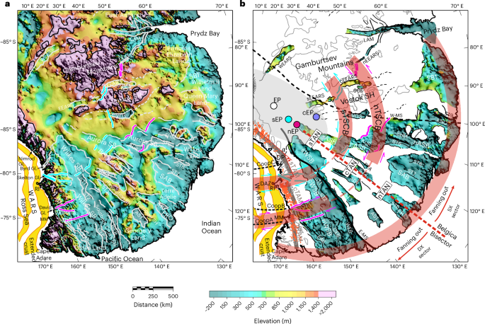
To address this, we searched for independent support in gravity, magnetic and seismic data, as well as in existing crustal and lithospheric models. This was one of the most rewarding stages of the work, because the same broad organization seemed to reappear in the geophysical evidence.
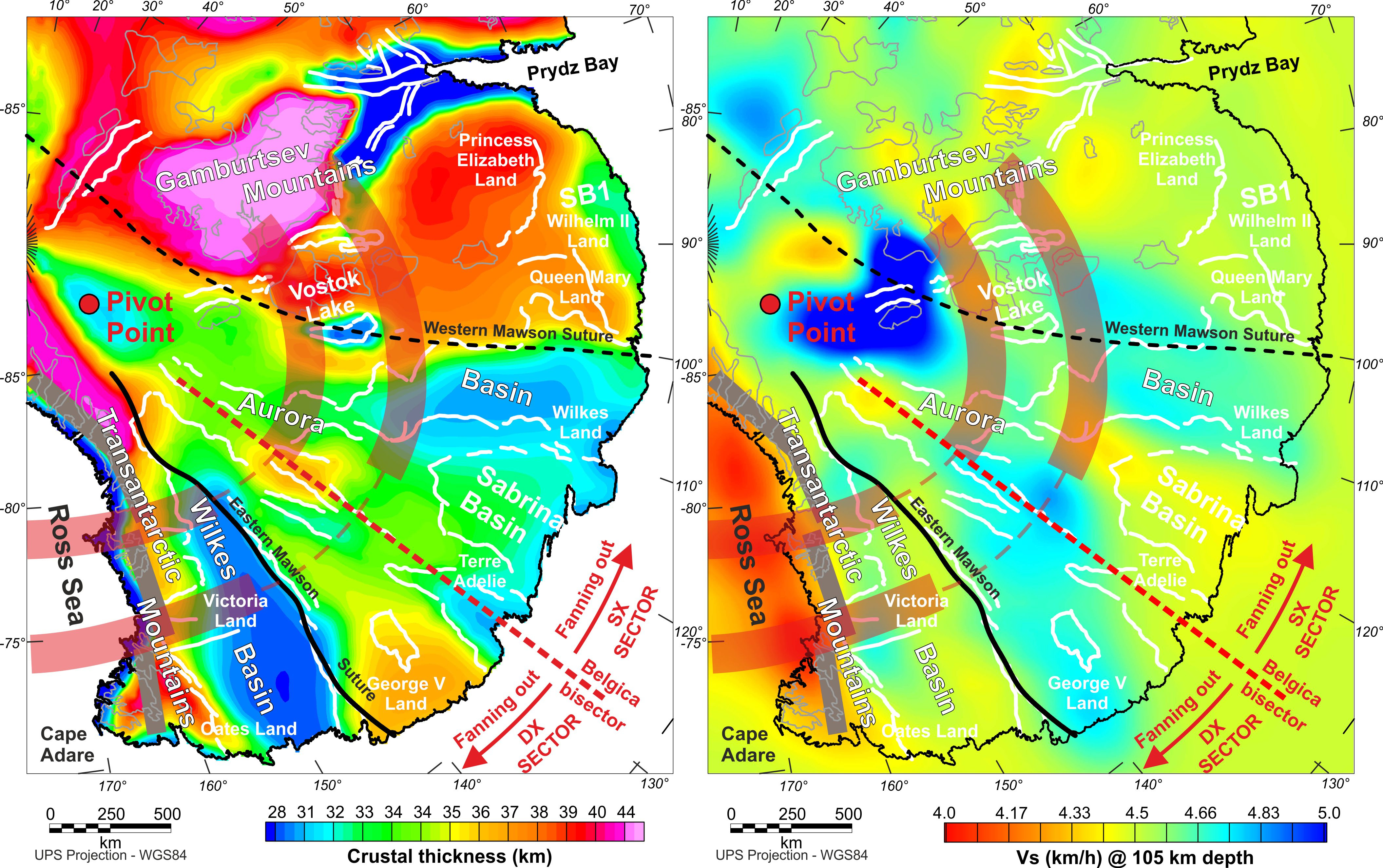
The left panel shows crustal thickness (source: https://doi.org/10.1016/j.gr.2020.08.010), while the right panel shows S-wave velocity anomalies in the lithosphere (source: https://doi.org/10.1038/s43247-025-02140-4). In both datasets, the fan-shaped pattern is recognizable, supporting the idea that the radial organization observed in the subglacial topography is rooted in a deeper tectonic process.
The radial pattern visible in the subglacial topography was echoed by deeper crustal and lithospheric features. This suggested that the fan-shaped basin province is not merely a superficial landscape feature, but has a tectonic origin.
Opening a continental-scale fan
That led us to the final and biggest question: what kind of tectonic process could generate a fan-shaped structure at a continental scale?
We explored several possibilities, but the interpretation that best fit the observations was a mechanism known as distributed rotational extension. In simple geometric terms, this process is analogous to the opening of a folding fan: a pivot region remains relatively fixed while deformation spreads outward across a wide area.
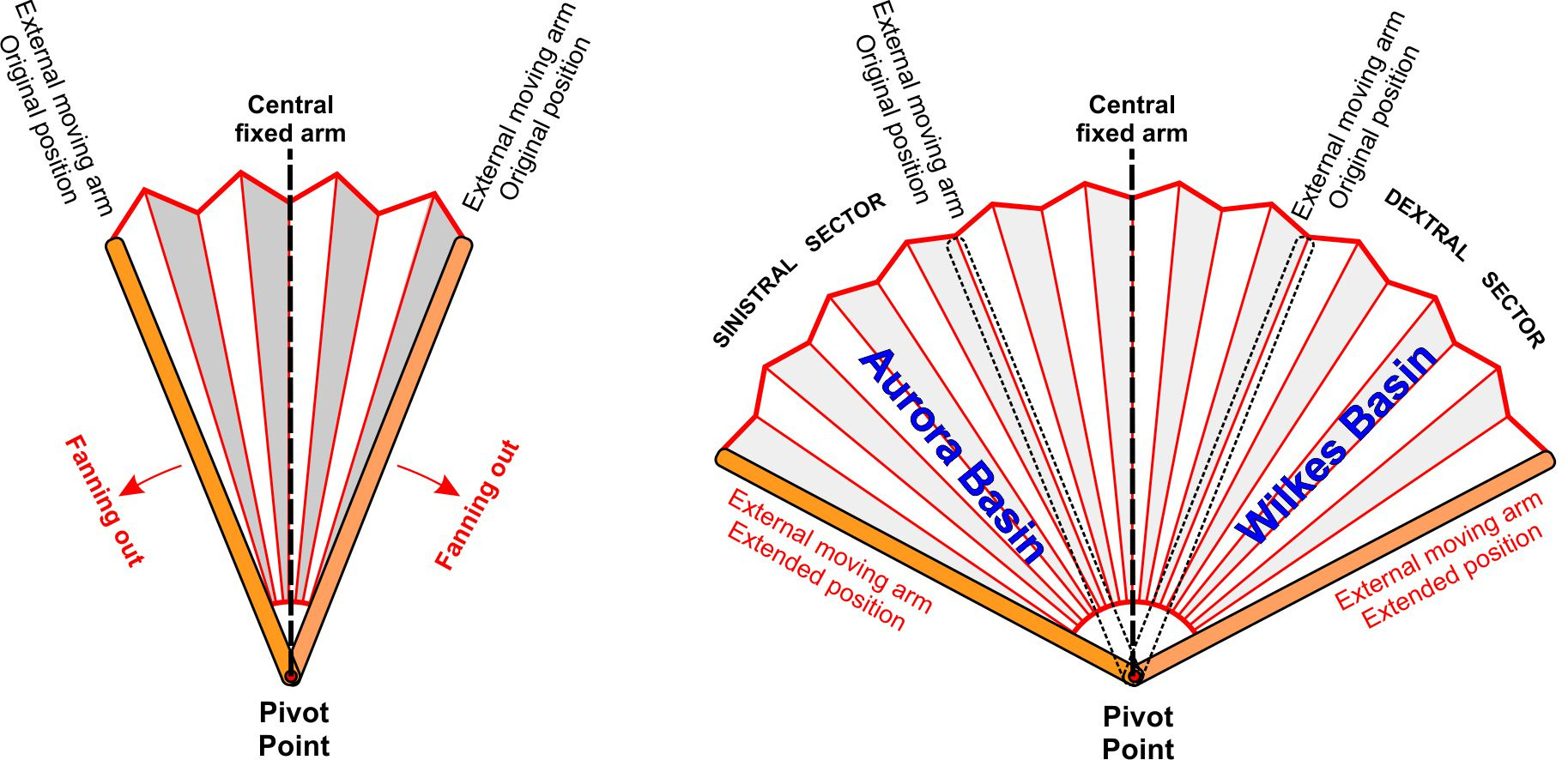
Rotational extension can be schematically represented by the opening of a fan around its pivot point.
In this analogy, deformation is distributed outward from a relatively fixed pivot region, producing a radial pattern similar to that observed in the East Antarctic Fan-shaped Basin Province.
The same idea can be visualized with a hand analogy: “left hand - thumb down”. If the thumb represents the pivot and the fingers are spread outward, the fingers mimic the radial structures, while the spaces between them resemble the triangular basins formed during the opening.
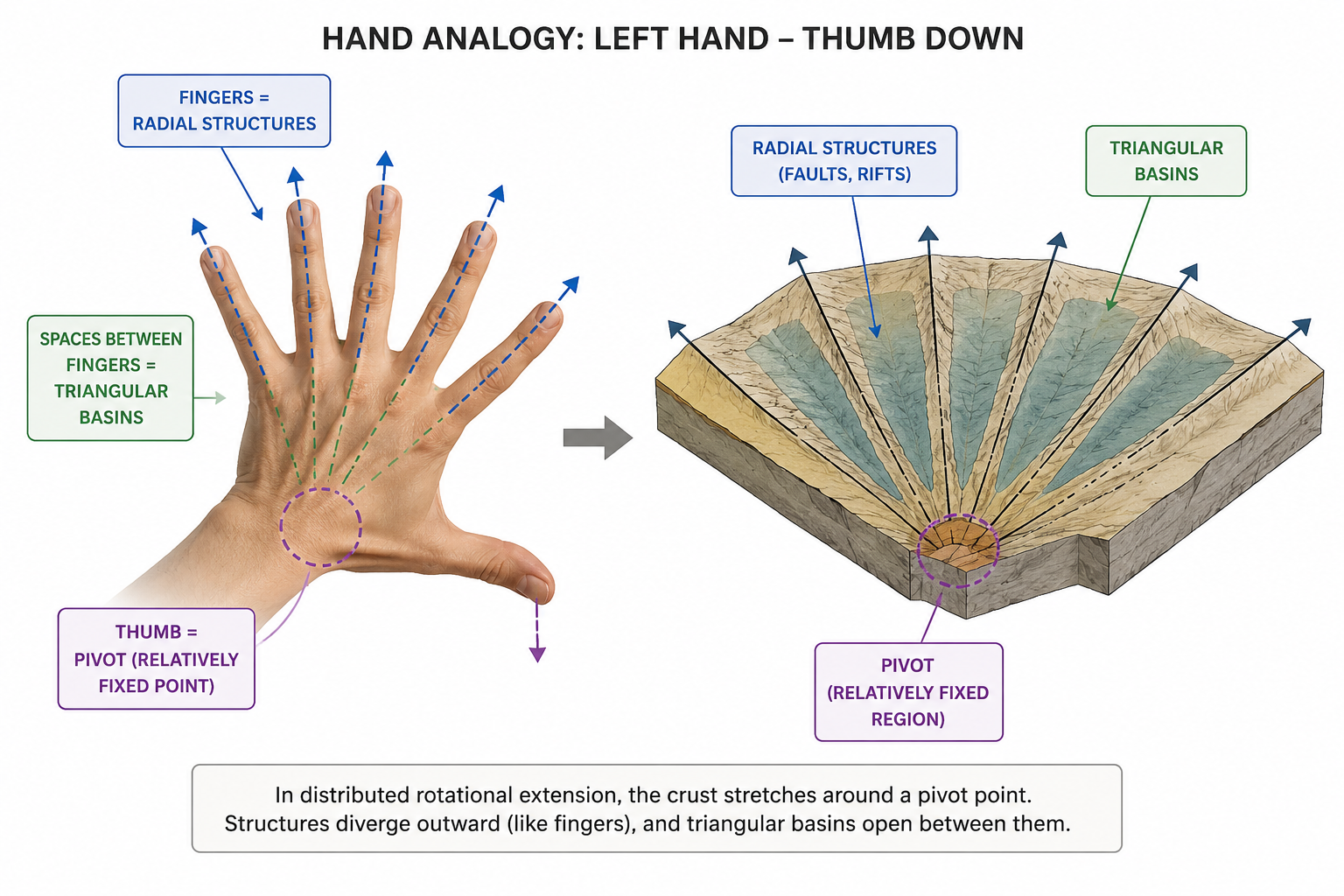
Hand analogy for rotational extension
With the left hand and the thumb pointing downward, the thumb represents the pivot, while the fingers spread outward mimic the radial structures; the spaces between the fingers resemble the triangular basins formed during the opening process.
If this interpretation is correct, the East Antarctic example may represent one of the largest and most compelling examples of distributed rotational extension yet recognized in continental crust.
In our view, this mechanism can explain not only the radial basin pattern itself, but also some of its broader geological consequences. These include possible links with the uplift of the Gamburtsev Mountains, the segmentation and differential uplift of the Transantarctic Mountains, and even the structural framework that influenced the breakup between Antarctica and Australia.
Remarkably, although the fracture zones formed later within the oceanic crust, their position and orientation appear to be spatially aligned with the main radial structures of the continental fan-shaped province. This suggests that the pre-existing continental architecture may have influenced where these oceanic structures developed during seafloor spreading.
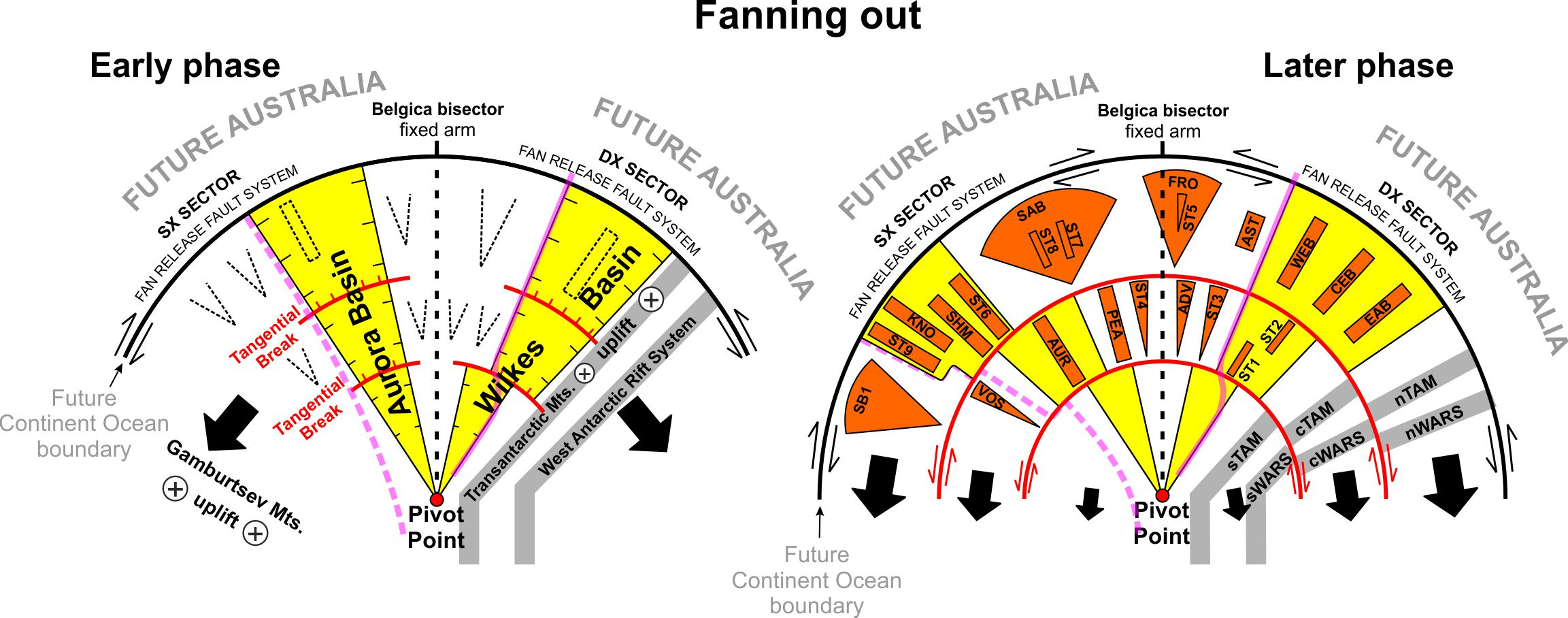
Proposed two-phase conceptual kinematic model illustrating the formation of the East Antarctic Fan-shaped Basin Province
The model is not to scale. In the early phase, the Wilkes and Aurora basins formed as the two main radial basins, while rotation of the Transantarctic Mountains together with the West Antarctic Rift System and uplift of the Gamburtsev Mountains are inferred. In the later phase, circular shear belts developed. Lateral shifts along these belts are proposed to have displaced the Wilkes and Aurora basins and segmented both the Transantarctic Mountains and the basins of the West Antarctic Rift System in the Ross Sea region.
Questions that remain open
At the same time, some of the most important questions remain unresolved.
In particular, the timing of this extension is still uncertain, as is its ultimate geodynamic cause. The deformation may have developed over more than one phase, and understanding what drove it may require geodynamic mechanisms that are still poorly understood, or perhaps not yet fully recognized.
This uncertainty is not a weakness of the study, but one of the reasons why the finding is exciting. The East Antarctic lithosphere remains one of the least directly observed geological domains on Earth.
From a simple observation to a tectonic model
For us, the most satisfying aspect of the study was seeing a visual intuition gradually become a geological hypothesis, and then a tectonic model supported by multiple independent datasets. This work was made possible by the support of the Italian National Antarctic Research Programme and the University of Genoa, and by a wider international collaboration with the University of Exeter, Durham University, the Swiss Federal Institute of Technology (ETH Zurich), the National Institute of Oceanography and Applied Geophysics (OGS), the Federal Institute for Geosciences and Natural Resources (BGR), the University of Bremen. Together, these institutions brought together international expertise across multiple fields of geophysics, glaciology and geology, providing the scientific interdisciplinary framework needed to investigate one of the most remote and least directly accessible geological regions on Earth.
The story began with a simple observation: both major and secondary basins seemed to radiate.
From there, it opened into the possibility that a large part of East Antarctica preserves the imprint of a single continent-scale extensional process, whose legacy may still shape both the landscape beneath the ice and the behaviour of the ice sheet above it.
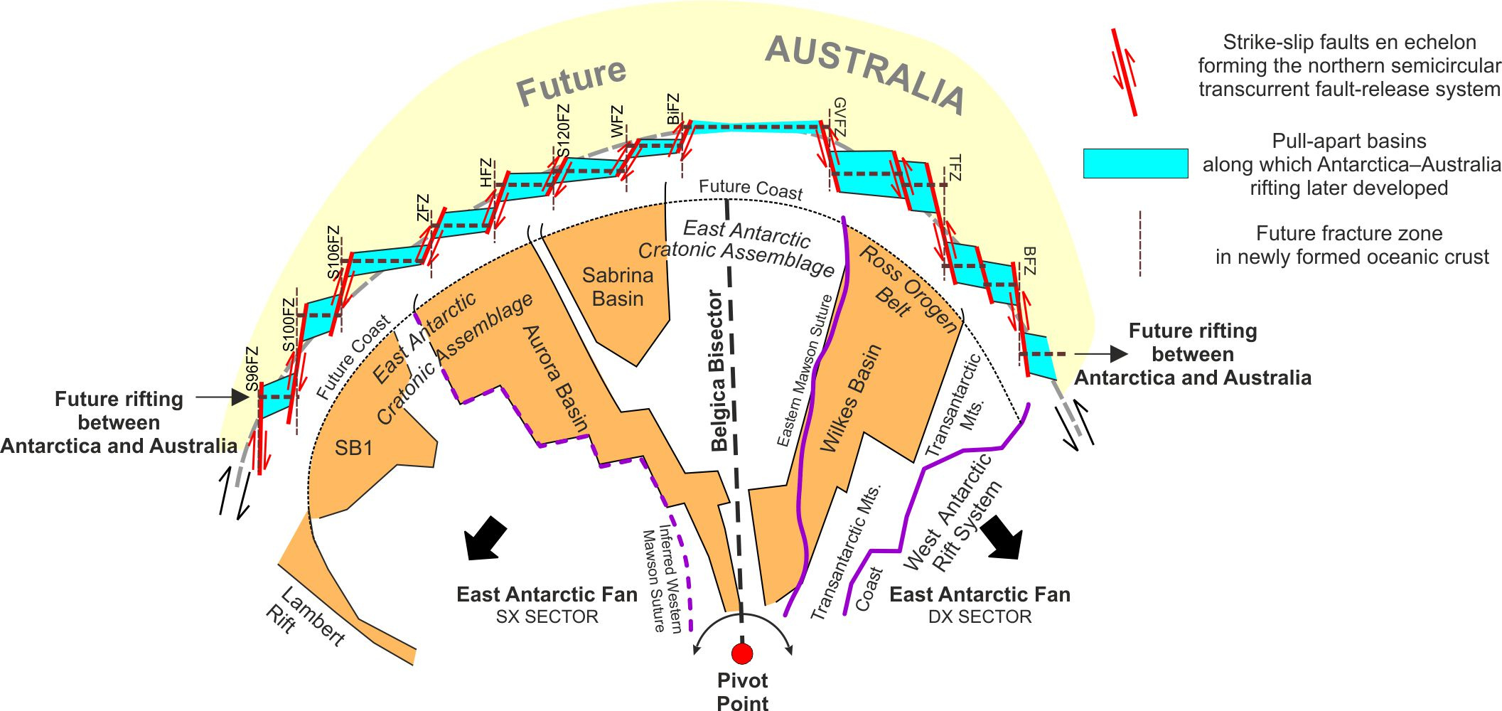
On the continent, rotational extension produced the radial architecture of broadly triangular basins observed beneath the East Antarctic Ice Sheet. Along the northern margin of the fan, where Australia would later separate from Antarctica, increasing lateral offset within the northern transcurrent fault-release system generated east–west pull-apart basins. These structures provided a broadly semicircular framework that was later followed by rifting shaping the conjugate Antarctic–Australian margins.
I am a geophysicist at the Applied Geophysics Laboratory of the University of Genoa. My research focuses on the use of geophysical methods to investigate the subsurface, with applications ranging from structural geology and geothermal exploration to mineral resources, geotechnical studies, and environmental challenges. I am particularly interested in integrating geophysical data with geological information to improve our understanding of complex subsurface systems.
Follow the Topic
-
Nature Geoscience
A monthly multi-disciplinary journal aimed at bringing together top-quality research across the entire spectrum of the Earth Sciences along with relevant work in related areas.


Please sign in or register for FREE
If you are a registered user on Research Communities by Springer Nature, please sign in