Avoidable danger? Once upon a time in Kakhovka
Published in Earth & Environment
The Kakhovka Dam in Ukraine collapsed on June 6, 2023. Analyzing satellite images made available to the media, we observed that the dam was overtopping and certain ancillary structures of the spillway appeared compromised even before the collapse. Further investigation revealed that local media had reported unusually low and high water levels shown in the Kakhovka reservoir in early 2023. This prompted us to consider operational mishaps that might have led to these dangerous hydrological conditions.
First of all, it’s important to note that starting from 2022, the Kakhovka Dam has been caught in a war situation. Control over the dam during this time has been uncertain, with potentially different parties managing it at various times.
To understand what went wrong, we tackled the 'AAA' questions: Anomalies, Attribution, and Actions (What if), despite limited access to local data.
Anomalies: Irregular operation and extreme water level fluctuations.
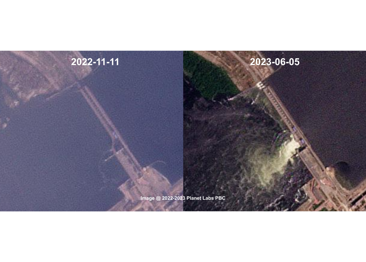
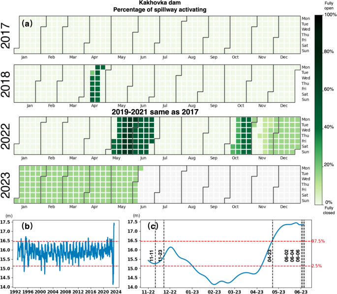
Utilizing optical satellite images and remotely sensed altimetry data, we identified a series of events: a bridge segment disappeared on November 11, 2022, spillway activation was fixed at around 15% by late November, water levels dropped to record lows around January 31, 2023, overtopping began on April 23, and spillway structures started failing by late May. This sequence of events raises a crucial question: Are these anomalies connected, and if so, how?
Attribution: Unregulated outflow.
Our hypothesis centers on unregulated outflow beginning in late November 2022, which continued unchecked until the Kakhovka Dam ultimately breached. Through remote sensing and global streamflow modeling, we found that the outflow was predominantly gravity-driven during this period. This scenario explains the progression from extreme low to high water levels, which we could have confirmed as early as January 2023, months before the collapse. So, whoever occupied the Kakhovka Dam didn’t care to regulate it.
Action: What if the danger had been recognized sooner?
Rolling back the clock, suppose someone responsible for the dam's safety decided to act. Even with limited site access, opening more sluice gates to nearly 50% of spillway activation by the end of March could have reduced the likelihood of overtopping to below 3%. Such measures could still have significantly mitigated the risk during the dam's critical final months starting from April 2023. If on-site intervention was impossible, issuing hazard notices or evacuation warnings could have lessened the impact of the collapse.
In summary, the Kakhovka Dam was in a precarious hydrological state before its failure, largely due to unregulated outflow for over six months.
Note that our study does not pinpoint the direct cause of the collapse but highlights the potential of early warning systems for water hazards, powered by advanced remote sensing technologies.
Looking Ahead: Proposing the WATCH system
We propose a new system, named WATCH (Figure 1). This system integrates cutting-edge techniques for simulating river inflow and water system dynamics, as well as monitoring infrastructure operation and structural integrity. By fusing modeling and remote sensing, we can achieve comprehensive assessments even when conventional access is restricted. The core of WATCH is to encode the 'AAA' questions into software, enhancing better decision-making to protect the sustainability of our water systems.

Reference:
Gao, H., Birkett, C. & Lettenmaier, D. P. Global monitoring of large reservoir storage from satellite remote sensing. Water Resour. Res. 48, W09504 (2012).
Riggs, R. M., Allen, G. H., Brinkerhoff, C. B., Sikder, M. S. & Wang, J. Turning lakes into river gauges using the LakeFlow algorithm. Geophys. Res. Lett. 50, e2023GL103924 (2023).
Wang, J. et al. GeoDAR: georeferenced global dams and reservoirs dataset for bridging attributes and geolocations. Earth Syst. Sci. Data 14, 1869–1899 (2022).
Zhao, T., Yang, D., Cai, X., Zhao, J. & Wang, H. Identifying effective forecast horizon for real-time reservoir operation under a limited inflow forecast. Water Resour. Res. 48, W01540 (2012).
Mo, C.-X. et al. A quantitative model for danger degree evaluation of staged operation of earth dam reservoir in flood season and its application. Water Science and Engineering 11, 81–87 (2018).
Tavakkoliestahbanati, A., Milillo, P., Kuai, H. & Giardina, G. Pre-collapse spaceborne deformation monitoring of the Kakhovka dam, Ukraine, from 2017 to 2023. Communications Earth & Environment 5, 1–9 (2024).
Follow the Topic
-
Communications Earth & Environment

An open access journal from Nature Portfolio that publishes high-quality research, reviews and commentary in the Earth, environmental and planetary sciences.
Related Collections
With Collections, you can get published faster and increase your visibility.
Archaeology & Environment
Publishing Model: Hybrid
Deadline: Mar 31, 2026
Drought
Publishing Model: Hybrid
Deadline: Mar 31, 2026


Please sign in or register for FREE
If you are a registered user on Research Communities by Springer Nature, please sign in