Balancing Growth: A New Framework for Regional Equilibrium in Iran and Beyond
Published in Social Sciences, Earth & Environment, and Economics




Why Regional Equilibrium Matters
Regional disparities—whether in infrastructure, healthcare, or economic opportunities—can undermine social cohesion and hinder national progress. In Iran, for instance, uneven development has led to significant imbalances, with the western regions thriving while the eastern areas lag behind. Our research aims to bridge these gaps by providing a measurable, actionable approach to regional planning.
Key Findings from the Study
A Five-Pillar Framework:
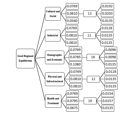
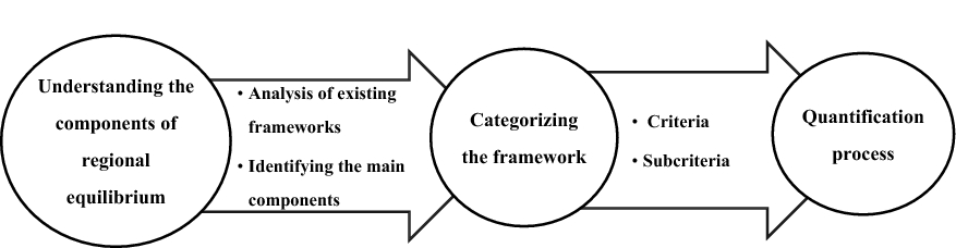
We identified five main criteria essential for evaluating regional equilibrium:
- Cultural and Social (e.g., literacy rates, education access).
- Industrial (e.g., industrial workshops, energy consumption).
- Demographic and Economic (e.g., employment rates, GDP per capita).
- Physical and Infrastructural (e.g., mobile connectivity, road networks).
- Health and Treatment (e.g., doctor-to-population ratios, hospital beds).
These criteria, broken into 60 sub-criteria, offer a granular view of regional strengths and weaknesses.
Quantifying Progress:
Using direct indicators (e.g., number of active mobile lines, general practitioners per capita), we demonstrated how to quantify disparities. For example:
A rise in mobile connectivity from 6% (2016) to 22% (2017) in Iran signaled improved infrastructure.
Health sector metrics, like the ratio of healthcare workers to population, revealed critical gaps needing intervention.
Expert-Driven Weighting:
To prioritize actions, we incorporated expert opinions to weight each criterion. This ensures policies align with the most urgent regional needs.
Implications for Policymakers
Our framework isn’t just theoretical—it’s a practical toolbox for governments and NGOs to:
- Diagnose inequalities using measurable indicators.
- Allocate resources efficiently based on data-driven priorities.
- Track progress over time, ensuring accountability.
Beyond Iran: A Global Blueprint
While tailored to Iran’s context, our methodology is adaptable. Regions worldwide can customize the framework to their unique environmental and socio-economic conditions, fostering equitable growth everywhere.
Conclusion
Regional equilibrium isn’t a luxury; it’s a necessity for sustainable development. Our study provides a roadmap to turn this vision into reality, empowering stakeholders to build balanced, just, and thriving communities.
Call to Action
Explore the full study here and join the conversation: How can your region benefit from this framework? Share your thoughts in the comments!
Keywords: Regional planning, Iran development, spatial inequality, sustainable growth, policy framework.
About the Authors:
Ehsan Dorostkar: Ph.D Urbanism, Department of Urbanism, University of Guilan, Rasht, Iran.
Mahsa Najarsadeghi: PhD Urbanism, Department of Urbanism, Science & Research Branch, Islamic Azad University (SRBIAU), Tehran, Iran.
Acknowledgments: We thank the Statistics Center of Iran and all collaborators for their invaluable data and insights.
This post summarizes our open-access article in GeoJournal (2022). DOI: 10.1007/s10708-022-10641-4.
Engage with Us:
Follow our research on Twitter | LinkedIn.
Subscribe for updates on regional development studies!

Follow the Topic
-
GeoJournal
This journal is an international journal devoted to all branches of spatially integrated social sciences and humanities.

Related Collections
With Collections, you can get published faster and increase your visibility.
Topical Collection on Integrating AI with RS-GIS for Climate Change, Disaster Risk, and Urban Resilience
The rapid advancement of Artificial Intelligence (AI), Machine Learning (ML), Deep Learning (DL), and Geospatial Artificial Intelligence (GeoAI) has revolutionized the way Earth Observation (EO) data are processed, interpreted, and utilized for environmental monitoring and decision-making. The unprecedented availability of multi-source satellite datasets, including optical, radar, hyperspectral, thermal, LiDAR, and UAV observations, combined with high-performance cloud computing platforms, has created new opportunities for addressing global environmental and societal challenges.
Climate change has become one of the most pressing issues facing humanity, influencing ecosystems, natural hazards, water resources, agriculture, urban environments, biodiversity, and human health. Understanding these complex interactions requires advanced analytical approaches capable of integrating large-scale geospatial datasets with intelligent computational models.
This Topical Collection aims to provide a leading international platform for cutting-edge research that integrates Artificial Intelligence with Remote Sensing, Geographic Information Systems (GIS), Earth Observation, and spatial data science to improve the monitoring, prediction, assessment, and management of climate change and its impacts on both natural and human systems. The issue will highlight innovative methodologies that combine satellite observations, spatial modelling, machine learning, and explainable AI to support evidence-based environmental management and sustainable development.
Significance of the Topical Collection
Recent advances in satellite missions such as Sentinel-1, Sentinel-2, Landsat 8/9, MODIS, WorldView, PlanetScope, ICEYE, NISAR, GEDI, ICESat-2, and UAV technologies have generated unprecedented volumes of Earth observation data. Simultaneously, AI techniques—including deep learning, transformers, graph neural networks, reinforcement learning, and explainable AI have transformed geospatial analysis by enabling automated feature extraction, accurate prediction, and intelligent decision support.
Despite these advances, significant challenges remain in integrating heterogeneous geospatial datasets with AI models while ensuring robustness, interpretability, scalability, and operational applicability. This Special Issue seeks to bridge these gaps by promoting interdisciplinary research that combines geospatial sciences with modern AI methodologies to address climate-related challenges at local, regional, and global scales.
The Topical Collection will encourage the development of innovative frameworks capable of:
- Monitoring climate change and environmental dynamics.
- Predicting natural hazards and disaster risks.
- Assessing ecosystem vulnerability and resilience.
- Evaluating urban expansion, heat islands, and urban morphology.
- Quantifying population exposure and socio-economic vulnerability.
- Supporting sustainable resource management and policy formulation.
- Advancing explainable, trustworthy, and operational GeoAI solutions.
Expected Contributions
This Topical Collection seeks papers that:
- Develop novel AI algorithms for Earth observation.
- Integrate multiple satellite datasets for environmental monitoring.
- Improve climate change prediction accuracy.
- Introduce explainable and trustworthy GeoAI methodologies.
- Apply AI to disaster risk reduction.
- Advance urban sustainability research.
- Demonstrate operational applications using real-world datasets.
- Provide transferable frameworks applicable across different geographic regions.
- Support the United Nations Sustainable Development Goals (SDGs).
This Topical Collection will provide a comprehensive platform for showcasing state-of-the-art research at the intersection of AI, RS, GIS, and Earth Observation. By bringing together experts from geospatial sciences, environmental studies, computer science, climate research, and urban planning, it will foster interdisciplinary collaboration and accelerate the development of innovative AI-driven solutions for climate change mitigation, environmental sustainability, disaster resilience, and evidence-based decision-making. The collection aims to become a key reference for researchers, practitioners, policymakers, and industry leaders working to harness geospatial intelligence and artificial intelligence for a more resilient and sustainable future.
The Topical Collection will be coordinated by Aqil Tariq at@buaa.edu.cn; aqiltariq85@gmail.com. Please feel free to contact the organizer/editor about the suitability of a manuscript for this Topical Collection. We particularly welcome submissions from researchers based in diverse regions and contexts and interdisciplinary submissions that integrate spatial demography with other fields.
Please submit your manuscript through the Springer SNAPP system, with a note on the cover letter stating that the submission is for consideration for the Topical Collection on Integrating AI with RS-GIS for Climate Change, Disaster Risk, and Urban Resilience.
Publishing Model: Hybrid
Deadline: Ongoing
Parks and Protected Areas Around the World: Emerging Directions in Current Research
The 21st century is one in which the geography of the world’s protected places, the national parks, forests, wilderness, historic monuments, marine reserves, and landscapes are receiving overdue attention. An enormous amount of work is being generated examining these places using a variety of social science and physical science research methods, ranging from participant observation and surveys to satellite-based water quality observations.
This work does not just celebrate these places but examines the struggles to keep them intact and healthy in the face of population and land use pressures, air and water pollution, habitat degradation, and climate change. They may serve as the lungs of the planet, its water filters, and its cultural repositories of our values and hopes.
Significance of the Special Collection
This Special Collection aims to provide a leading international platform for cutting-edge research that examines the geography of protected areas, integrating social science, with Remote Sensing, Geographic Information Systems (GIS), Earth Observation, and spatial data science to improve the monitoring, prediction, assessment, and management of these areas.
Expected Contributions
This Special Collection seeks papers that examine:
- Climate Change, Resilience, and Protected Areas
- Environmental health
- Visitation to protected areas and visitor activities within them
- Environmental consequences of protected area development
- Air and water pollution
- Ecosystem Services and Human Well-Being
- Transportation to and within protected areas
- Human/wildlife interactions
- Cultural landscapes within protected areas
- Conflict and protected areas
- Social, Economic, and Political Perspectives on Protected Areas
- Governance, Institutions, and Conservation Policy
- Biodiversity Protection and Ecosystem Management
- Geospatial Technologies, Data, and Innovation for Conservation
- Emerging challenges in parks and protected areas conservation
- Innovative funding and investment approaches for long-term protected area stewardship
- Threats to protected areas (mining, energy development, urban growth)
- Maritime protected areas
- Gateway Communities, Regional Development, and Protected Areas
- The future of protected areas in the Anthropocene
This Special Collection will provide a comprehensive platform for showcasing state-of-the-art research at the intersection of social and physical science. It will foster interdisciplinary work that will integrate disparate fields that have examined these places to find new solutions to pressing problems. The collection aims to become a key reference for researchers, practitioners, policymakers, and industry leaders working to harness geographical knowledge and expertise for a more resilient and sustainable future.
Submission Guidelines
Authors are invited to submit their manuscripts through the Geojournal-Springer SNAP submission portal. Please refer to the journal's guidelines for detailed instructions on manuscript preparation and submission.
Contact: Selima Sultana at GeoJounralEiC@uncg.edu and Joe Weber at jweber2@ua.edu.
Publishing Model: Hybrid
Deadline: Ongoing