Bedrock erosion in a 180 m deeply incised gorge
Published in Earth & Environment
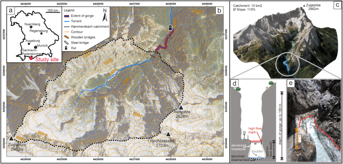
The site
The gorge we are talking about is situated in southern Bavaria, close to the border to Austria. The 'Höllentalklamm' lies in an approximately 10 km2 large catchment right on the foot of the highest mountain of Germany, the Zugspitze. With an average inclination of 110% it's extremly steep and promotes very rapid accumulation of surface runoff during high-intensity rainfall events. And this is what happened in June 2020: A local precipitation event with intensities of 50-60 mm/h (DWD, Radar Measurements) caused the torrents in the area to swell up quickly and pick up great amounts of loose debris.
The erosive flow event
The water rushing down the hillsides and channels accumulated in the main torrent of the valley and was then able to transport sediment such as sand and pebbles in suspension. This so-called hyperconcentrated flow was then forced through the narrow 'Höllental'-gorge. The witdh of the gorge varies between 1.3 and 14.9 m and is roughly 900 m long. Due to the narrow cross-section and steep gradient, the flow was able to transport great amounts of sediment in the flow column and shift boulders with volumes up to 20 m3. One can imagine that an event like this will leave some traces. Just a few days later we inspected the gorge and discovered how the flow affected the rock walls and the channel bed.

Assessing the geomorphic changes
Even by eye we were able to detect some changes on the rockwalls of the limestone channel. In some places rock fragments were loosened and subsequently entrained in the flow. This was visible by smaller and also some bigger scarps on the rockwalls. In the majority of the channel we were also able to see how the entrained sediment in the flow acted similar to 'sandblasting' on the rockwalls. This was clearly visible by the bright white/grey color of the bedrock walls. By mapping the transition between the darker and this very bright colored rock we could also determine the 'erosive flow height' along the whole gorge.

Quantifying the changes
To calculate how much and where the flow eroded the bedrock walls we needed a more precise analysis. Due to a rockfall monitoring campaign just two weeks prior to the event we luckily had a laserscan point cloud (LiDAR) that represented the original rockface withouth the erosion. We complemented this by performing another LiDAR campaign and then calculating the difference between both point clouds. The results showed a lateral (perpendicular to the flow, i.e. 'into the rockwall') erosion depth up to 43 mm for a 10-m section of the gorge and that the highest erosion impact is generally at 1.1-1.2 m above the channel bed. By this analysis, we gained the fist dataset of a quantiative change detection demonstrating the geomophic changes in a narrow bedrock gorge by a hyperconcentrated flow.
Implications for gorge formation
The results showed exceptionally high erosion rates for bedrock walls, especially because this all happened in a single event lasting approximately one hour. While other short-term measured fluvial incision rates for bedrock fail to match long-term rates , the highly erosive power of hyperconcentrated flows (and debris flows) could close that gap. Most observations today are likely to be done in channels which are in a state of 'non-incision'[1] while there were periods of very high incision in the past. We postulate that with different conditions regarding the water and sediment availability than what we find today, repeated extreme events like hyperconcentrated flows would have a leading role in bedrock gorge formation. Also, they would have an accelerating effect on the incision rates due to its extremely high erosive power. Lateglacial times did provide nearly unlimited debris and water supply after the beginning of the glacial retreat. Moraine deposits were redistributed and the geomorphological activity was high[2]. Therefore, it is not surprising that gorges are now found in paraglacial environments in the Alps and beyond.
References
1. Finnegan,N. J.,Schumer, R.&Finnegan,S. Asignature of transience in bedrock river incision rates over timescales of 10(4)-10(7) years. Nature 505, 391–394 (2014).
2. Ballantyne, C. K. Paraglacial geomorphology. Quat. Sci. Rev. 21, 1935–2017 (2002).
Follow the Topic
-
Communications Earth & Environment

An open access journal from Nature Portfolio that publishes high-quality research, reviews and commentary in the Earth, environmental and planetary sciences.
Related Collections
With Collections, you can get published faster and increase your visibility.
Climate extremes and water-food systems
Publishing Model: Open Access
Deadline: May 31, 2026
Archaeology & Environment
Publishing Model: Hybrid
Deadline: Mar 31, 2026

Please sign in or register for FREE
If you are a registered user on Research Communities by Springer Nature, please sign in