A new Machine Learning Approch for Landslide suspectibility Mapping
Published in Social Sciences and Earth & Environment
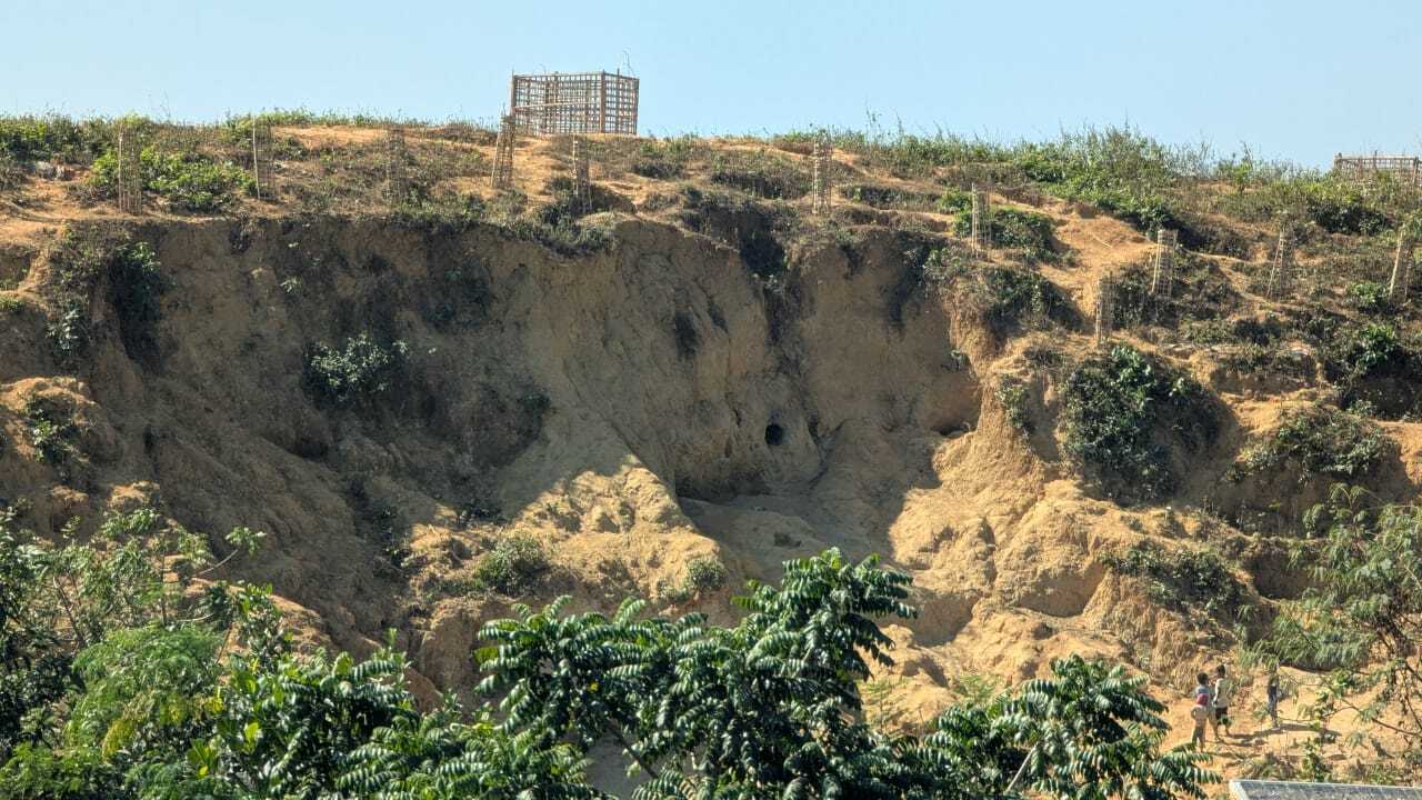
Landslides represent one of the most destructive natural hazards, posing serious threats to human lives, infrastructure, and the environment. These mass movements of soil, rock, or debris down a slope are triggered by various natural and anthropogenic factors, including intense rainfall, earthquakes, slope saturation, deforestation, and unplanned urbanization. In recent decades, the frequency and severity of landslides have increased significantly due to rapid land-use change and climate variability. To mitigate such impacts, accurate landslide susceptibility mapping (LSM) has become a vital component of disaster risk reduction, land-use planning, and sustainable development. Landslide susceptibility refers to the spatial probability of a landslide occurring in each area, based on the combination of conditioning factors that influence slope instability. These factors generally include topographic (slope, aspect, curvature), geological (lithology, faults, soil type), hydrological (rainfall, drainage density), and anthropogenic (road construction, land use) parameters. Traditionally, LSM has relied on heuristic or statistical methods such as frequency ratio, weights of evidence, and logistic regression, which, while useful, often struggle to capture the complex nonlinear interactions among conditioning variables.
In recent years, machine learning (ML) techniques have revolutionized the field of landslide susceptibility assessment. ML models are data-driven and capable of learning intricate relationships between input features and outcomes without requiring explicit assumptions about their distributions. Techniques such as Support Vector Machine (SVM), Random Forest (RF), Artificial Neural Networks (ANN), Naïve Bayes, Gradient Boosting, and Decision Trees have been widely adopted to model landslide occurrence patterns. These models can process large, multidimensional datasets and provide high predictive performance by recognizing hidden correlations among conditioning variables. However, despite their success, traditional machine learning approaches often demand extensive and balanced training datasets, including both landslide (presence) and non-landslide (absence) samples. In many regions, reliable absence data are either unavailable or highly uncertain because it is difficult to verify whether a location has never experienced a landslide or simply lacks documentation. Additionally, complex parameter tuning, computational costs, and potential overfitting problems limit the operational usability of some machine learning methods in landslide studies.
To overcome these limitations, researchers have introduced the Maximum Entropy (MaxEnt) model as a novel machine learning approach for landslide susceptibility analysis. Originally developed for ecological modeling specifically species distribution prediction MaxEnt is a statistical learning algorithm based on the principle of maximum entropy, which states that the best approximation to an unknown probability distribution is the one with the highest entropy, subject to the constraints derived from known information. In simpler terms, MaxEnt estimates the most uniform (least biased) probability distribution possible, given the environmental conditions at observed landslide locations. Unlike many supervised learning models, MaxEnt is a presence-only model, meaning it requires only landslide occurrence data rather than both presence and absence points. This unique feature makes it highly suitable for regions where landslide inventories are incomplete or where non-landslide data are unreliable.
In a MaxEnt-based landslide susceptibility framework, each environmental or conditioning variable is treated as a predictor layer. The algorithm extracts the characteristics of pixels corresponding to known landslide locations and identifies relationships between these variables and landslide presence. By applying the maximum entropy principle, the model generates a probability surface that represents the likelihood of landslide occurrence across the entire study area. The output is a continuous susceptibility map, typically ranging from 0 (least susceptible) to 1 (most susceptible), which can be reclassified into categories such as very low, low, moderate, high, and very high susceptibility zones.
The introduction of MaxEnt into landslide studies offers several distinct advantages over conventional ML and statistical models. Firstly, it performs exceptionally well with limited and presence-only datasets, which are common in developing or data-scarce regions. Secondly, the model employs regularization techniques to avoid overfitting a common issue in data-driven models by penalizing overly complex relationships. Thirdly, MaxEnt provides a clear measure of variable importance, enabling researchers to identify and rank the most influential conditioning factors contributing to slope instability. Additionally, its results are interpretable, reproducible, and compatible with Geographic Information Systems (GIS), which facilitate spatial analysis, visualization, and integration with other hazard and risk layers.
Numerous studies have validated the efficacy of the MaxEnt model in diverse geomorphological and climatic settings. For example, in the Himalayan region, where landslides are frequent due to steep slopes and intense monsoon rainfall, MaxEnt has demonstrated excellent predictive capability with Area Under Curve (AUC) values often exceeding 0.9. Similarly, in Mediterranean and tropical mountainous areas, researchers have reported that MaxEnt performs competitively compared to machine learning models like Random Forest, SVM, and Gradient Boosting, especially when dealing with incomplete inventories. The probabilistic nature of MaxEnt also allows for the integration of remote sensing datasets, such as those derived from satellite imagery (e.g., NDVI, soil moisture, or precipitation intensity), improving spatial accuracy and temporal sensitivity.
Beyond its technical advantages, MaxEnt contributes significantly to practical decision-making in hazard management. The resulting susceptibility maps are invaluable for identifying high-risk zones that require slope stabilization measures, early warning systems, or land-use restrictions. Furthermore, policymakers and disaster managers can use MaxEnt-based maps to allocate resources effectively for landslide prevention and post-disaster recovery efforts.
Despite its numerous strengths, the MaxEnt model is not without limitations. It assumes that the available landslide inventory represents an unbiased sample of the environmental conditions associated with landslides, which may not always hold true. Sampling bias, resolution mismatches among input layers, and spatial autocorrelation can affect the model’s accuracy.
In conclusion, the introduction of the MaxEnt model marks a significant milestone in the evolution of machine learning applications for landslide susceptibility analysis. Its ability to operate effectively with limited data, resist overfitting, and provide interpretable probabilistic outputs has made it one of the most promising models in spatial hazard prediction. By incorporating MaxEnt within a GIS environment, researchers can generate highly detailed susceptibility maps that support evidence-based planning and policy formulation. Therefore, the introduction of MaxEnt as a new machine learning model has not only enhanced predictive modeling capabilities but also deepened our understanding of the intricate relationships between environmental factors and slope processes offering a powerful, data-driven tool for the future of landslide hazard assessment.
Follow the Topic
-
Discover Sustainability

A multi-disciplinary, open access, community-focussed journal publishing results from across all fields relevant to sustainability research whilst supporting policy developments that address all 17 of the United Nations Sustainable Development Goals (SDGs).
Related Collections
With Collections, you can get published faster and increase your visibility.
Artificial Intelligence and Digital Innovation in Advancing Sustainable Development Goals
This Collection is expected to explore the role of Artificial Intelligence (AI) and digital innovation in improving progress toward the United Nations Sustainable Development Goals (SDGs). We aim to highlight interdisciplinary research, technological breakthroughs, and practical applications that leverage AI-driven tools, data science, and digital systems to tackle global challenges such as poverty, climate change, healthcare, education, and sustainable infrastructure. This Collection provides a platform for advancing responsible and inclusive innovation by closely bridging technology and sustainability.
This Collection supports and amplifies research related to SDG 9, SDG 11, SDG 12, SDG 13 & SDG 16
Keywords: Artificial Intelligence, Digital Innovation, Sustainable Development Goals, Smart Technologies, Data Science, Climate Action, Ethical AI, Smart Cities, Digital Transformation.
Publishing Model: Open Access
Deadline: Mar 01, 2026
Advancing Sustainable Development: The Role of Circular Economy Practices, Green Innovation and Corporate Responsibility
Achieving sustainable development, as envisioned in the United Nations’ 2030 Agenda, requires transformative solutions to reconcile economic growth with environmental and social imperatives. Circular economy practices, green innovations, and corporate responsibility stand out as critical drivers in this effort—reducing resource depletion, fostering innovation, and embedding accountability into global systems. Yet, their combined potential to accelerate progress toward the Sustainable Development Goals (SDGs) remains underexplored. This Collection aims to unravel these synergies, offering actionable insights for researchers, policymakers, and practitioners committed to a sustainable future.
Keywords: Sustainable Development, Circular Economy Practices, Green Innovation, Corporate Responsibility, Challenges and Opportunities in Sustainable Development.
This Collection supports and amplifies research related to SDG 7, SDG 12, SDG 13 and SDG 17.
Publishing Model: Open Access
Deadline: Apr 01, 2026


Please sign in or register for FREE
If you are a registered user on Research Communities by Springer Nature, please sign in