Advancing Antarctic Geoheritage: A Call to the Geoscience Community
Published in Earth & Environment and Ecology & Evolution
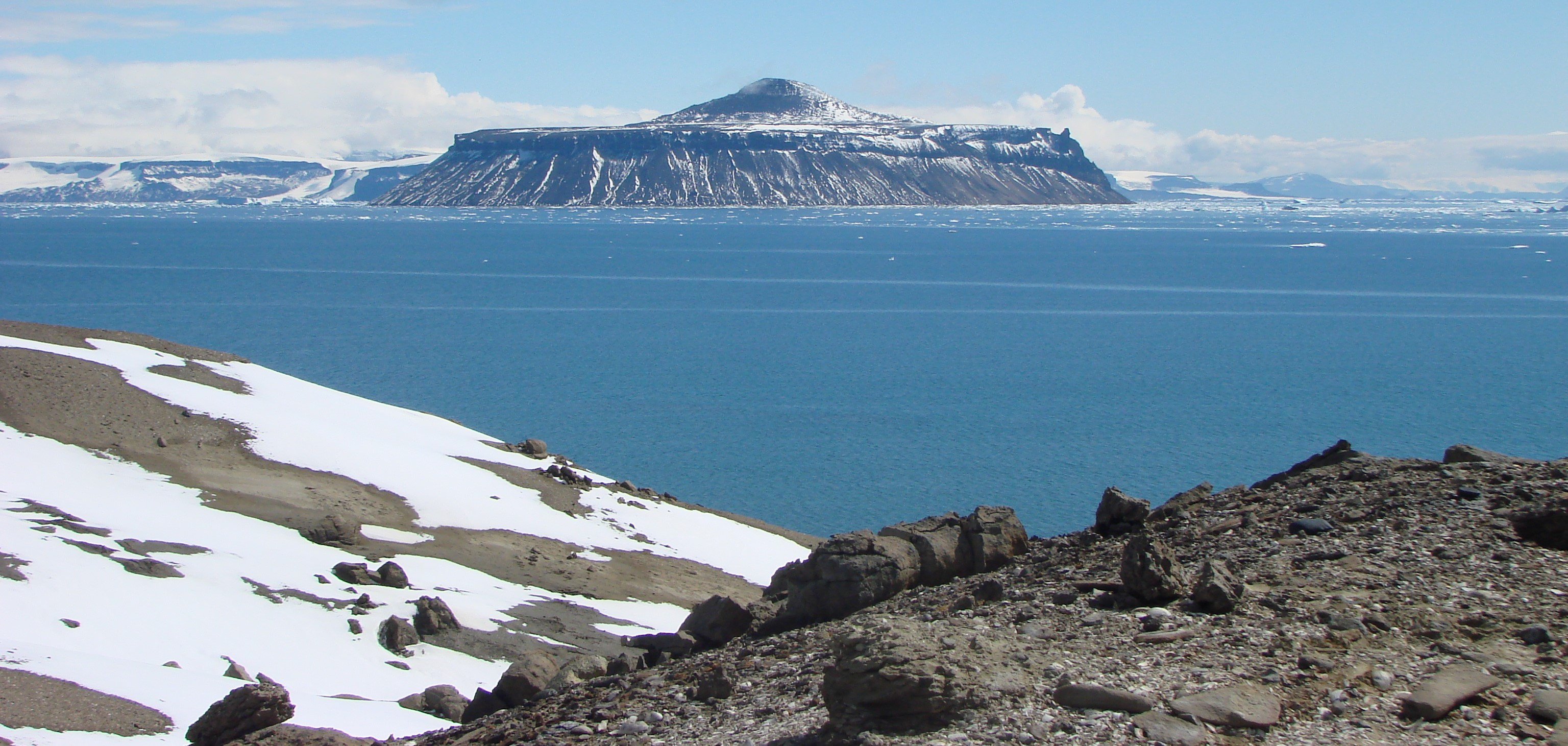
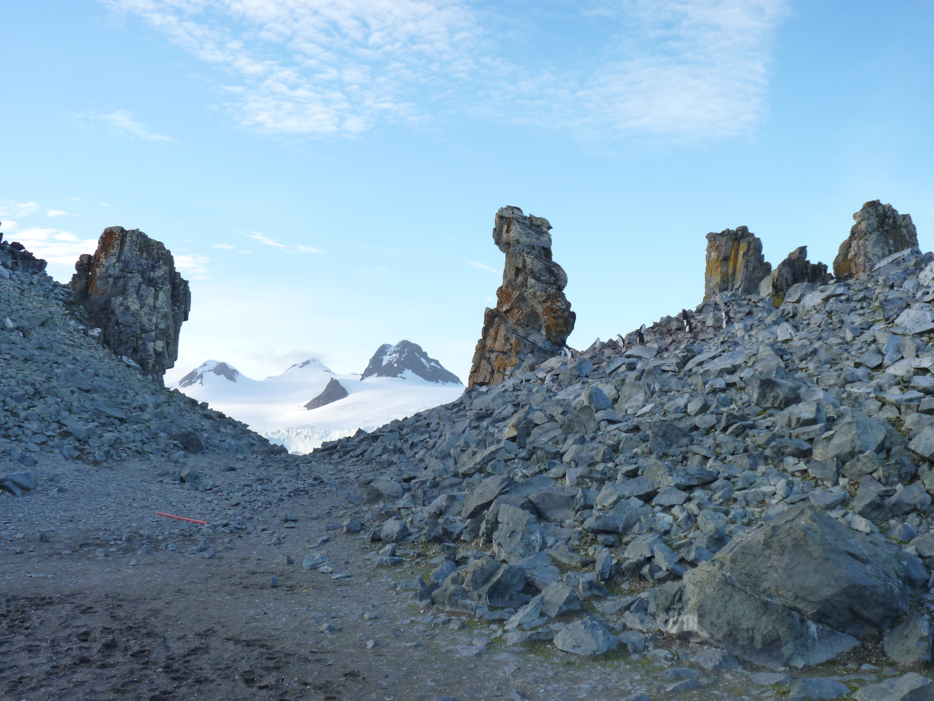
Antarctica is often perceived as a remote, pristine, and almost timeless continent. Yet, beneath its ice and across its exposed outcrops lies one of the most extraordinary geological archives on Earth. From the assembly and breakup of Gondwana to the evolution of active margins and rift systems, Antarctica preserves key chapters of our planet’s history that remain critical for understanding global tectonics, palaeoclimatic and palaeobiological evolution, and the long-term dynamics of the Earth system.
Recognizing the scientific, educational, and conservation value of this geological legacy, the Scientific Committee on Antarctic Research (SCAR) formally approved the creation of the Expert Group on Geological Heritage and Geoconservation (EG-GEOCON) in late 2022. The group is chaired by Anne Grunow (President), with Cliff Atkins (Vice-President) and Enrique Díaz-Martínez (Secretary). It aims to advance the identification of Antarctic geological sites of exceptional value and to contribute SCAR advice to the Committee for Environmental Protection (CEP) and the Antarctic Treaty Consultative Meeting (ATCM) on matters related to the conservation of geological heritage.
Why Antarctic Geoheritage Matters
Geological heritage, or geoheritage, encompasses sites and features that hold outstanding scientific value due to their relevance for understanding Earth history. In Antarctica, this value is amplified by the continent’s pivotal role in global geological evolution and by the limited number of accessible, well-preserved geological records worldwide.
The formal identification of Antarctic Geological Heritage Sites (Geosites) is not merely symbolic. It supports the long-term preservation of irreplaceable geological archives, promotes responsible scientific access, and integrates geological values into broader Antarctic conservation frameworks.
A Methodology Aligned with International Standards
To advance the protection of outstanding geological values within Antarctica, EG-GEOCON agreed that the procedure for identifying geological heritage sites should follow the methodology of the Global Geosites Project, adapted to the unique conditions of the Antarctic Treaty area. One of the key benefits of this approach is that Antarctic Geosites are directly comparable with geological heritage sites identified worldwide by the International Union of Geological Sciences (IUGS).
The objective of the methodology currently used for Antarctica is to select the most important sites for Earth sciences, adopting a global perspective and a comparative view, resulting in the selection of sites worthy of international recognition.
This methodology involves two fundamental steps:
-
The selection of Geological Frameworks representative of Antarctic geological evolution
-
The subsequent identification of Geosites that best express and document each of these frameworks
From Geological Frameworks to Geosites
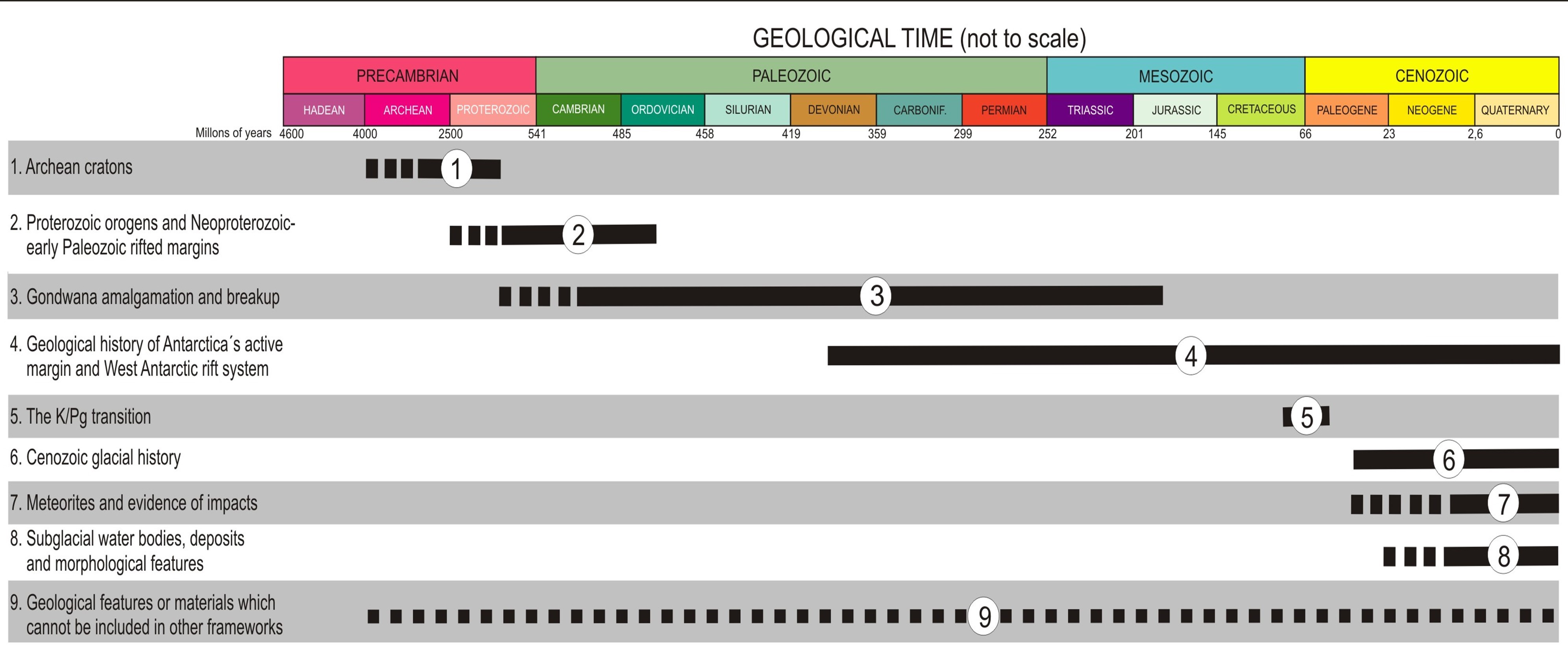
A Geological Framework refers to a regional geological feature, geotectonic unit, geological event, stratigraphic series, palaeobiological association, or any geological entity of international relevance. Following extensive expert consultation by a former SCAR Action Group, nine Geological Frameworks were identified and formally agreed upon for Antarctica.
Whereas the definition of Geological Frameworks is now complete, the identification of Geosites is currently underway.
Geosites are not selected in isolation, but within a previously defined Geological Framework chosen for its international significance. To be selected, sites must represent the most complete and expressive manifestation of a given framework and allow the most comprehensive understanding of its nature and origins.
While Geological Frameworks do not require spatial delimitation, Geosites must be mapped to promote their proper management. Antarctic Geosites are identified exclusively for their high scientific value and do not have legal status under the Antarctic Treaty System. However, under exceptional circumstances, a small number of Geosites of outstanding geological value, or those particularly vulnerable to human impact, may be proposed for consideration as Antarctic Specially Protected Areas (ASPAs) through the formal designation process.
What Makes a Geosite Scientifically Outstanding
Geographical areas appropriate for consideration as Antarctic Geosites generally fall into one or more of the following categories:
-
Unique or singular sites, where features or processes are extremely rare or impossible to observe elsewhere
-
Best sites, containing the most representative examples of the features characterizing a Geological Framework
-
First sites, where key features or processes were identified for the first time, thus holding historical scientific value
-
Pattern or reference sites, chosen for the quality and continuity of their geological record
These criteria ensure that Geosites are selected based on their capacity to represent, explain, and document Antarctic geological evolution at the highest scientific level.
How Geosites Are Evaluated
After compiling the proposals, the EG-GEOCON Coordination Team prepares a consolidated list of candidate Geosites for each Geological Framework. Panels of selected experts then evaluate these proposals using a standardized scoring system designed to enhance differences and ensure transparency.
Sites that score above a predetermined threshold are selected as the best Geosites representing each Geological Framework.
This methodology has already been successfully applied. For instance, the previous work of the Action Group identified a single Geosite representative for Geological Framework 5, as documented in a peer-reviewed publication. This example illustrates how the framework-based, comparative approach leads to rigorous and internationally visible outcomes.
Current Focus: Frameworks 3 and 4
The EG-GEOCON Leadership Team is currently focusing on two Geological Frameworks for which new Geosite proposals are actively sought:
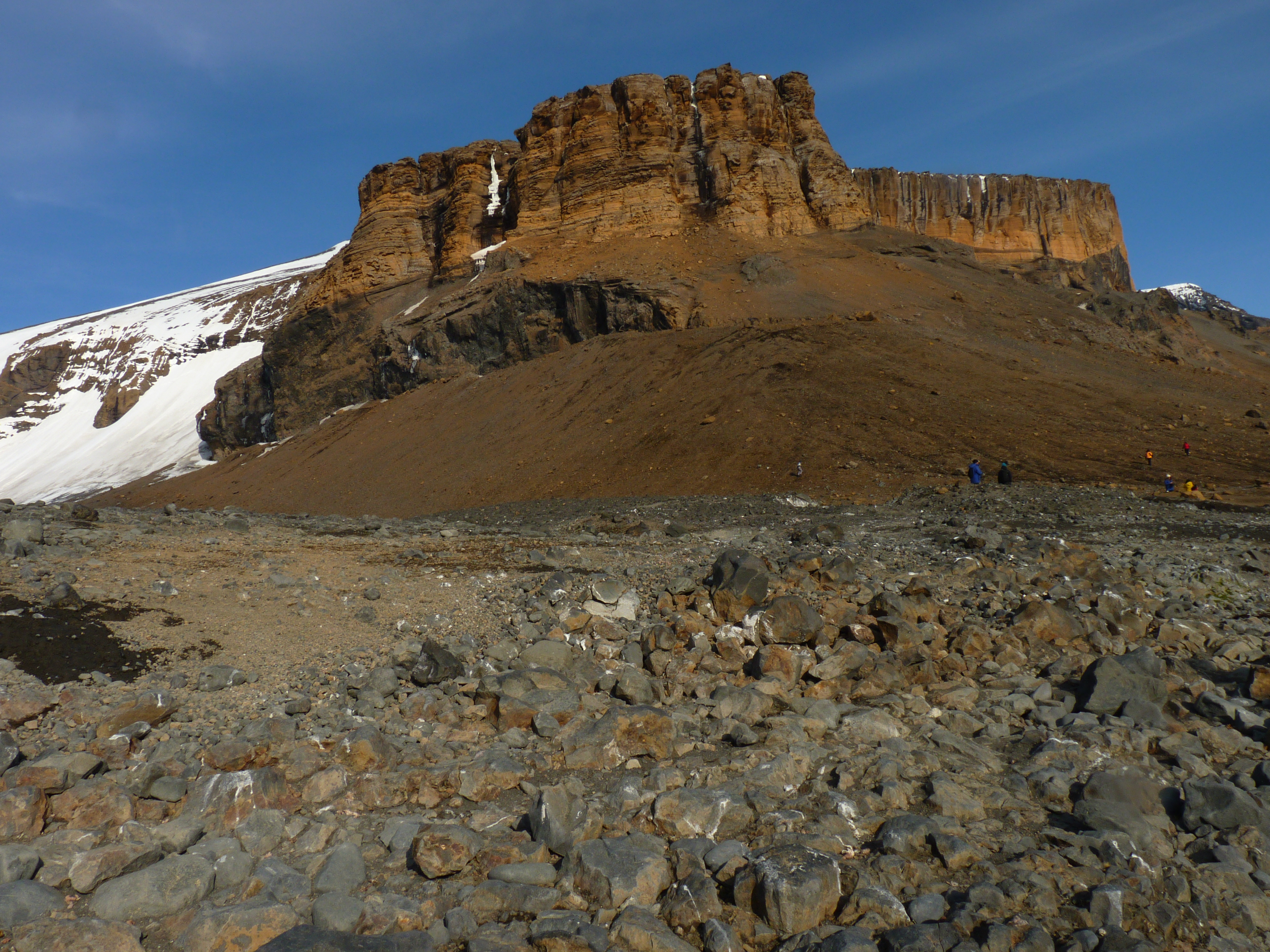
Framework 3: Gondwana Amalgamation and Breakup
This framework concerns:
-
Early Palaeozoic subduction and the Ross Orogeny
-
Pan-African orogens and sutures
-
The Kukri peneplain and classic Gondwana cover sequences
-
Palaeoclimatic and palaeontological records
-
The Ferrar Large Igneous Province
Framework 4: Geological History of Antarctica’s Active Margin and the West Antarctic Rift System
This framework involves:
-
Evidence for the formation and behaviour of the Antarctic active subduction zone and rift margins
-
Records of rift-related features tied to lithospheric thinning
-
The tectonic influence on Cenozoic ice flow in West Antarctica
Together, these frameworks address key processes linking deep Earth dynamics, surface geology, and cryospheric evolution.
Why This Matters Now
As Antarctic research increasingly intersects with global environmental change and conservation policy, the identification and protection of its geological heritage becomes more urgent than ever.
By contributing to the recognition of Antarctic Geosites, we collectively help safeguard the geological foundations of the southernmost continent for future generations.
A Call for Community Participation
EG-GEOCON invites Antarctic geoscientists to submit proposals for Geosites related to Frameworks 3 and 4. If these topics align with your expertise and you are interested in contributing, contact us at these emails:
Cliff Atkins: atkins@vuw.ac.nz
Enrique Díaz-Martínez: :e.diaz@igme.es
We would greatly appreciate receiving proposals or expressions of interest by 28 February 2026.


Please sign in or register for FREE
If you are a registered user on Research Communities by Springer Nature, please sign in