Discovering Urban Patterns Through Human Mobility and Virtual Space
Published in Social Sciences, Earth & Environment, and Law, Politics & International Studies
Explore the Research

 elsevier.com
Just a moment...
Skip to main content
Have you ever wondered how our daily movements shape the cities we live in? A recent study published in the Journal of Urban Management explores this very question by uncovering hidden patterns in human mobility using data from social media and urban travel. Titled "Discovering the Urban Pattern Through Human Mobility and Virtual Space," this research offers fascinating insights into how our movements for work, education, shopping, and leisure create interconnected triangular patterns in urban environments.
The Hidden Patterns of Human Mobility
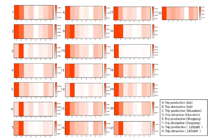
Cities are dynamic, ever-evolving entities shaped by the collective movements of their inhabitants. This study identifies a "triangular model" of human mobility, where three key activities—job, education, and shopping/leisure—form interconnected sides of a triangle. These patterns are not immediately visible but emerge when analyzing large datasets of daily trips.
Using data from Tehran, the research categorizes human mobility into four main types:
-
Job-related trips (e.g., commuting to work)
-
Education-related trips (e.g., traveling to schools or universities)
-
Shopping-related trips
-
Leisure-related trips (e.g., visiting parks or entertainment venues)
By mapping these movements, the study reveals that certain districts, like Tehran’s District 17, are dominated by work-related trips, while others, such as Districts 1–5, show a balanced mix of education, shopping, and leisure activities. This imbalance highlights socioeconomic disparities, where some areas serve as labor hubs while others cater to a more diverse range of activities.
The Role of Virtual Space
One of the most innovative aspects of this research is its integration of virtual space—social media data—with real-world mobility patterns. By analyzing geotagged posts and API data from municipal sources, the study bridges the gap between digital behavior and physical movement. This approach not only enhances our understanding of urban dynamics but also opens new avenues for smart city planning.
Key Findings
-
Triangular Mobility Model: Human mobility forms triangular patterns where job, education, and shopping/leisure activities are interconnected.
-
District Variations: Some urban areas are highly specialized (e.g., work-dominated), while others exhibit balanced mobility.
-
Virtual-Real Integration: Social media data provides valuable insights into movement trends, complementing traditional travel data.
Why This Matters
Understanding these patterns is crucial for urban planners and policymakers. For instance:
-
Transportation Networks: Identifying high-mobility zones can optimize public transit routes.
-
Economic Development: Recognizing labor-intensive districts can inform job market strategies.
-
Crisis Management: Mobility data can predict how people move during emergencies, like pandemics or natural disasters.
A Global Perspective
While the study focuses on Tehran, its methodology is applicable to cities worldwide. By replicating this approach, researchers and planners can uncover similar hidden patterns in their own urban environments, fostering smarter, more resilient cities.
Final Thoughts
This research is a testament to how big data and interdisciplinary approaches can revolutionize urban studies. By combining human mobility analysis with virtual space, we gain a deeper understanding of the invisible forces shaping our cities—and how to harness them for sustainable development.
What do you think about these hidden urban patterns? Could your city benefit from such an analysis? Share your thoughts in the comments!
Read the full study here (link to the article).
#UrbanPlanning #HumanMobility #SmartCities #DataScience #UrbanResearch


Please sign in or register for FREE
If you are a registered user on Research Communities by Springer Nature, please sign in