GGCP10: Bridging Data Gaps in Global Food Security Assessment
Published in Earth & Environment, Research Data, and Sustainability
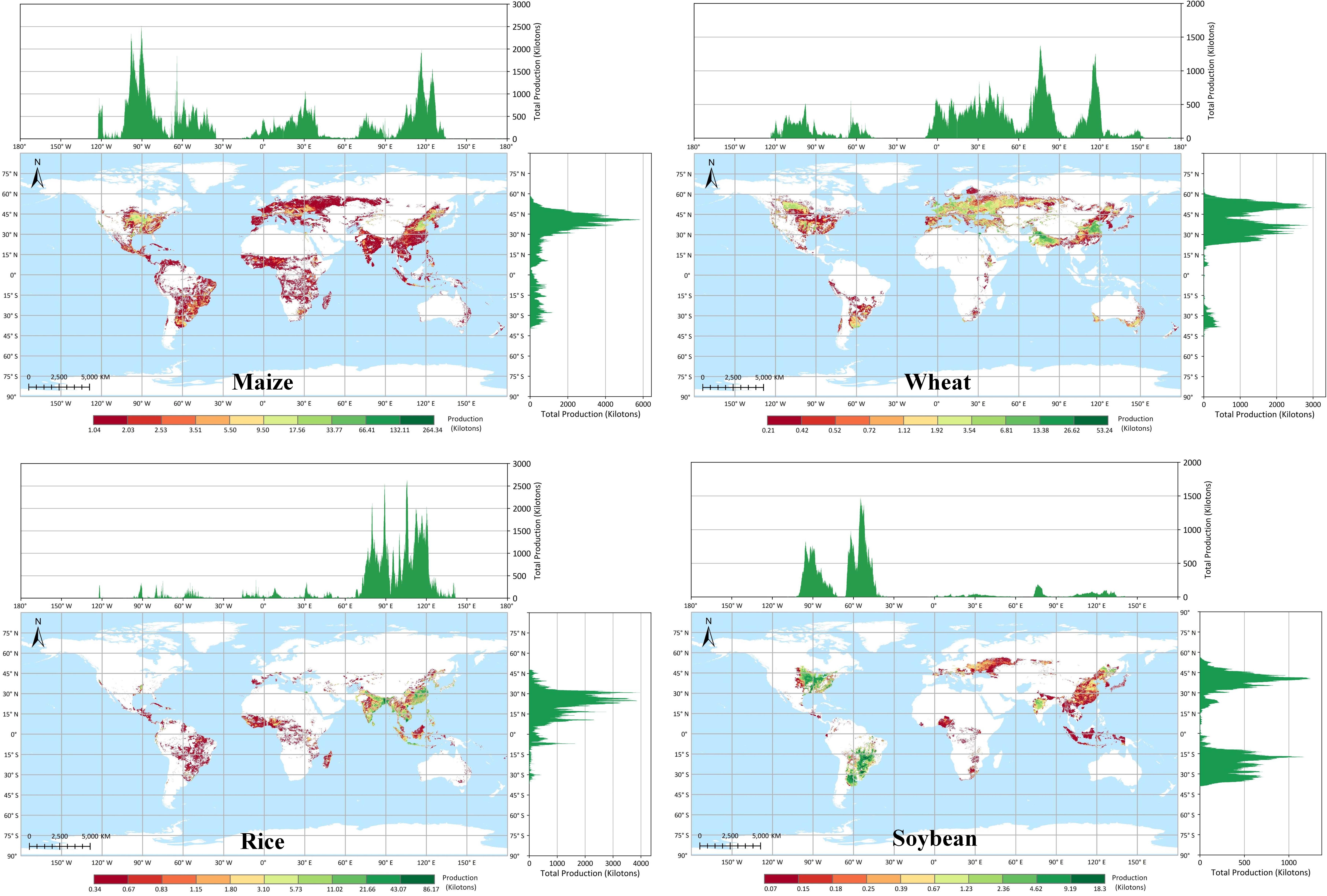

In assessing global food security trends, we face significant challenges. Climate change and population growth exert enormous pressure on national food supplies, and accurately evaluating these impacts requires a temporally continuous and spatially detailed global crop production dataset. Particularly in the context of intensifying global climate change and frequent extreme weather events, capturing and analyzing their effects on crop production demands data with high temporal and spatial resolution. Additionally, regional differences in agricultural production systems necessitate understanding crop distribution patterns at finer spatial scales. To achieve these objectives, creating a new high-precision global crop production map becomes critically important.
Facing this challenge, we developed GGCP10, a novel 10-kilometer resolution dataset offering continuous global crop production coverage for 2010-2020. Our methodology involves building a series of adaptively trained data-driven models based on agro-ecological zones, integrating massive multi-source data including statistical data, gridded production data, agro-climatic indicators, agronomic indicators, satellite products, and ground observations.
To ensure data reliability, we conducted extensive validation work. We collected statistical data from 2,823 administrative units across 43 countries, covering regions in Africa, Europe, North America, South America, Asia, and Australia. Validation results demonstrate that GGCP10 shows high accuracy in major crop-producing regions, with correlation coefficients ranging from 0.86 to 0.98 when compared with sub-national statistics.

We now make this data publicly available to support global food security research and policy-making. The spatiotemporal patterns revealed by GGCP10 help understand mechanisms driving crop production changes, enabling applications from regional production prediction to climate impact assessment. For instance, analyzing extreme weather impacts on crop production can inform agricultural insurance and disaster early warning systems.
We invite the research community to explore and utilize the GGCP10 dataset in their work, discover its value, and provide feedback to help us further optimize the dataset.
Follow the Topic
-
Scientific Data
A peer-reviewed, open-access journal for descriptions of datasets, and research that advances the sharing and reuse of scientific data.

Related Collections
With Collections, you can get published faster and increase your visibility.
Computer vision in plant science and agriculture
Publishing Model: Open Access
Deadline: Oct 10, 2026
Wearable and Computer Vision Data for Health and Behaviour Research
Publishing Model: Open Access
Deadline: Aug 08, 2026
Please sign in or register for FREE
If you are a registered user on Research Communities by Springer Nature, please sign in