How storm generating-flood events are intensifying over the central Mediterranean
Published in Earth & Environment, Mathematics, and Statistics

Landscape features support a range of ecosystems, influence hydrological processes and streamflow responses to climate change, and control feedback mechanisms between water, energy, and ecological processes1,2. In some parts of the world, changes in land use and extreme events are increasingly affecting such hydrological processes and responses3. However, despite recent observed increases in precipitation extremes in parts of the world, there is still little evidence of systematic increases in either flood magnitude or frequency compared to historical baseline conditions4. To overcome these difficulties, a new approach has been developed in this study and applied to the Eastern Liguria area (ELA, Fig. 1a).
Due to the weather features, and geo-morphological and hydrological characteristics of its territory, with coastal cities that do not extend inland, Liguria is exposed to natural phenomena that are potentially dangerous for people and things. Accordingly, the streams, descending from the upper parts of their basins, gradually receiving the inputs from the tributaries, flow into the terminal strip of their course, usually flat, and reach their natural destination, the sea (Fig. 1b).
Following storm and rainfall (Fig. 1c, black line), floods are low in winter and non-existent in mid-spring (April and May), increase slowly in mid-summer and then exponentially with the onset of autumn, with the maximum number of events in October, a slight decline in November and a drop to zero in December (Fig. 1c, blue histogram).
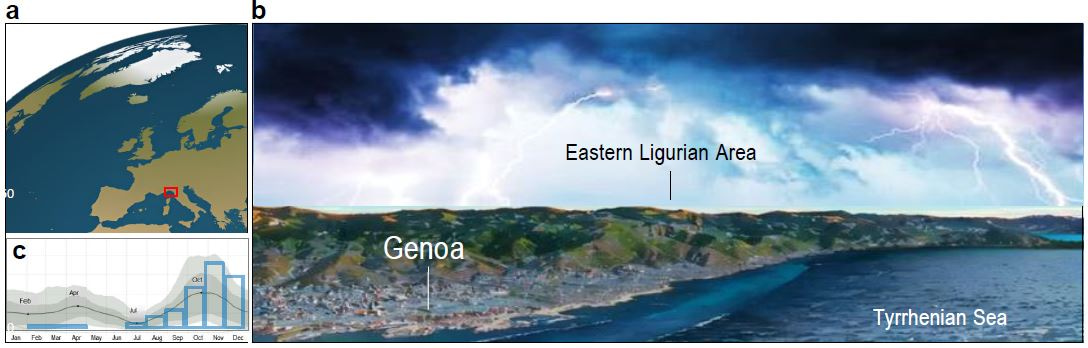
Fig. 1. Environmental setting of Eastern Ligurian Area (ELA). a. Geographical position within the Northern Hemisphere, with ELA outlined in red square (arranged from: https://www.clipsafari.com/clips/o188901-a-planetary-perspective-a-view-of-the-earth-from-space); b. Landscape perspective of Eastern Ligurian Area composed by Genoa city and behind mountains (image from Google Earth and arranged with VanceAI OnlineTool); c. Seasonal pattern of rainfall (black line) and floods (blue histogram) in ELA (from Weather Spark: https://weatherspark.com).
Temporal evolution of the reconstructed Annual Flood Intensification Index
In relatively small and mountainous basins, such as those composing the ELA, hydrological and geomorphological processes are characterized by nonlinear interactions between climatic constraints, land surface, and fluvial responses on different spatial and temporal scales5. As pointed out by Mulligan and Wainwright6, these hydrological processes are strongly dominated by the spatial connectivity of runoff-producing elements. With the help of the historical sequence of stormy seasons, it is possible to summarise the influences of climate variability on floods during the period 1582–2022 CE.
To identify possible trends and oscillations in the discrete data, the time-series was filtered using a 11-year low-pass Gaussian function (Fig. 2b, orange line) designed for this purpose following Førland et al.7.
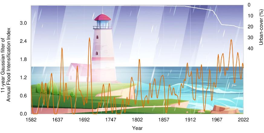
Fig. 2. Coevolution of the Annual Flood Intensification Index and urban cover. 11-year Gaussian filter of annual flood intensification index (orange line) and urban-cover change (white line in %) during the period 1582 and 2022 (background image adapted from: https://www.freepik.com/free-vector/lighthouse-rock-cliff-sea-shore-rain-vector-cartoon-illustration-summer-landscape-ocean-coast-with-beacon-thunderstorm-with-lightning-waves-sea_21845833.htm#page=2&query=landscapes%20floods&position=0&from_view=search&track=ais&uuid=e867e5bc-7709-47d2-990d-15384a30425e).
During the seventeenth century (central part of the LIA, 1500-1700 CE), thanks to an opposite expansion of the landscape from fruit-bearing chestnut groves to wild forests for charcoal production, the heaviest floods occurred only occasionally at that time. According to the Ligurian ironworks owner Domenico Gaetano Pizzorno (1725–1775), as reported by Baraldi8, there is a tendency that opposes conversion to wild forest. On the contrary, for less severe events, there are historical records of several floods between the 17th and late eighteenth century. In 1723, the Bishop of Brugnato, Monsignor Niccolò Leopoldo Lomellini (died 1754), criticized the management of the local hospital. He lashed them by reporting that the Most High had already punished them by allowing the Vara River and the Cravegnola (La Spezia Province) to invade and devastate all the plain in the place of Brugnato, as they admitted themselves (as reported by Piana et al.9, p. 215).
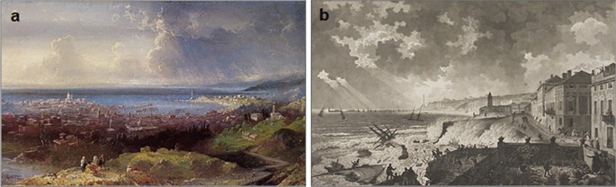
During the late eighteenth century, land use must not have been very different from that depicted in a large painting by the late-Baroque Italian painter Alessandro Magnasco (1667–1749). The painting, entitled The Bisagno valley seen from Villa Giustinani Cambiaso, reveals a rural landscape, dated c. 1740. In the late 18th and early nineteenth centuries (late LIA), floods began to intensify, as evidenced by the first change-point in 1787.
After these first turbulent years of the early nineteenth century, the floods of the ELA became temporarily more contained, and in the middle of this century we can recall the description of the Italian abbot and historian Goffredo Casalis (1781–1856) in his geographical dictionary of 1849, which is not much different from that of the Italian Catholic bishop, linguist and geographer Agostino Giustiniani (1470–1536) in his Castigatissimi Annali di Genova three centuries earlier10.
During this century, however, land use changed drastically, especially in the small valley basins and, obviously, in the city of Genoa itself. Historical maps provide us with a picture of the urbanization of the municipality of Rapallo11, which can be taken as representative of the ELA10. In this period, in fact, we can observe from Fig. 2 (white line), an exponential increase in the percentage of urban coverage from 5% in 1960 to 18% in 1980. At the same time, there was an increase in the intensification of flooding.
References
- Stephens, C. M., Lall, U., Johnson, F. M. & Marshall, L. A. Landscape changes and their hydrologic effects: Interactions and feedbacks across scales. Earth Sci. Rev. 212, 103466 (2021).
- Aygün, O., Kinnard, C., Campeau, S. & Pomeroy, J. W. Landscape and climate conditions influence the hydrological sensitivity to climate change in eastern Canada. Hydrol. 615, 128595 (2022).
- Vereecken, H. et al. Soil hydrology in the Earth system. Rev. Earth Environ. 3, 573–587 (2022).
- Brunner, M. I. et al. An extremeness threshold determines the regional response of floods to changes in rainfall extremes. Earth Environ. 2, 173 (2021).
- Førland, E. J., Hanssen-Bauer, I. & Nordli, P. Ø. Climate Statistics and Long-Term Series of Temperature and Precipitation at Svalbard and Jan Mayen. Report No. 21/97 KLIMA23 (Norwegian Meteorological Institute, 1997).
- Alexandersson, H. & Moberg, A. Homogenization of Swedish temperature data. Part I: Homogeneity test for linear trends. J. Climatol. 17, 25–34 (1997).
- Wanner, H., Pfister, C. & Neukom, R. The variable European Little Ice Age. Sci. Rev. 287, 107531 (2022)
- Baraldi, E. Cultura tecnica e tradizioni familiari. La “Notificazione sopra i negozi de’ ferramenti e delle ferriere” di Domenico Gaetano Pizzorno, padrone di ferriere a Rossiglione nel XVIII secolo (Quaderni del Centro di Studio sulla Storia della Tecnica del CNR di Genova”, n. 10, 1984) (in Italian).
- Piana, P., Watkins, C. & Balzaretti, R. Topographical art and historical geography: Amateur English representations of Ligurian landscape in the early nineteenth century. Bollettino e Notiziario del Centro Italiano per gli Studi Storico-Geografici 26, 195–221 (2018).
- Rosso, R. Bisagno: Il fiume nascosto (Marsilio Editori, 2014) (in Italian).
- Brandolini, P., Faccini, F., Paliaga, G. & Piana, P. Urban geomorphology in coastal environment: Man-made morphological changes in a seaside tourist resort (Rapallo, Eastern Liguria, Italy). Quaestiones Geographicae 36, 97–110 (2017).


Please sign in or register for FREE
If you are a registered user on Research Communities by Springer Nature, please sign in