Integration of geospatial technologies with multiple regression model for urban land use land cover change analysis and its impact on land surface temperature in Jimma City, southwestern Ethiopia
Published in Earth & Environment
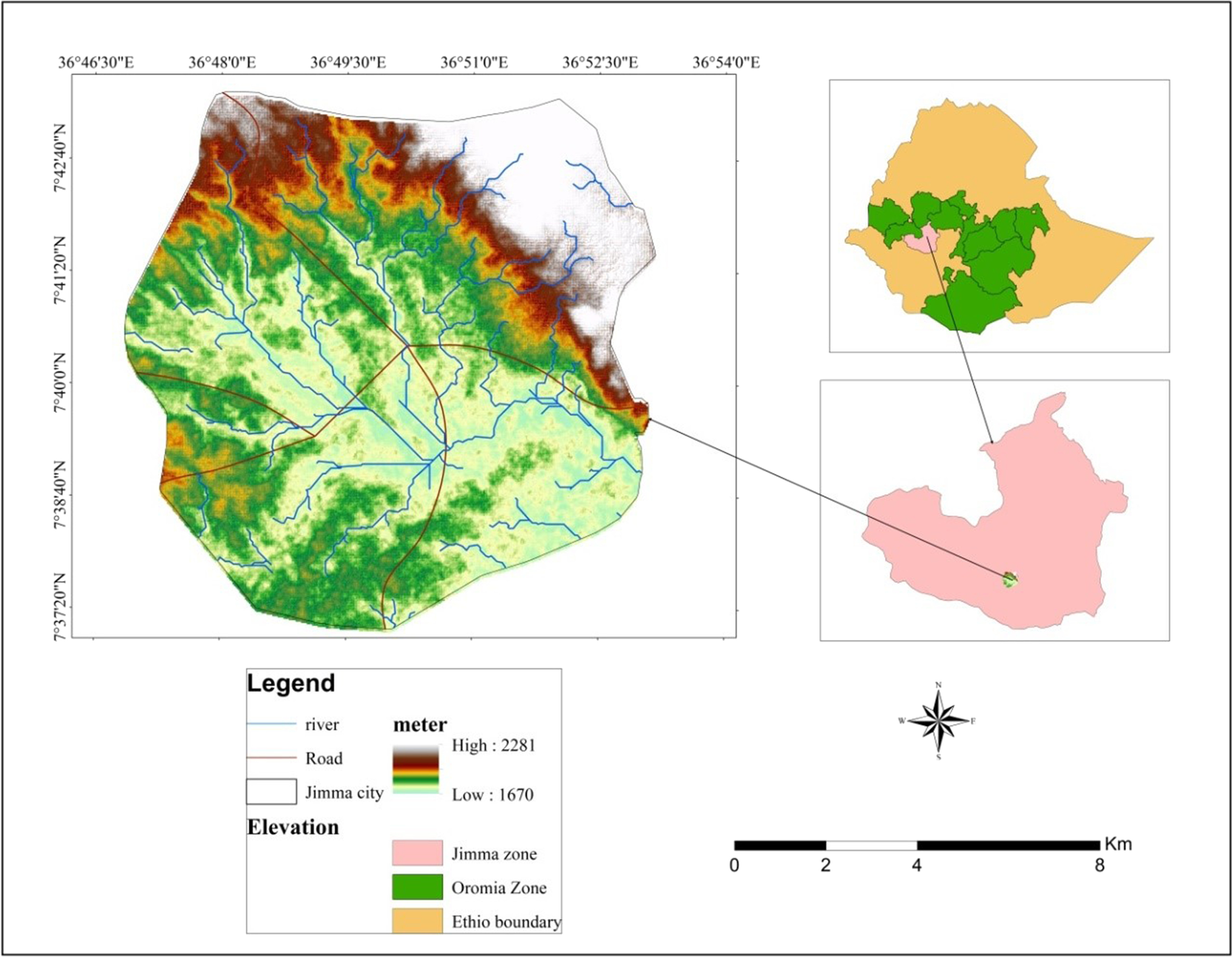

Rapid urbanization and population growth are the main problems faced by developing countries that lead to natural resource depletion in the periphery of the city. This research attempts to analyze the impacts of urban land use land cover (LULC) change on land surface temperature (LST) from 1991 to 2021 in Jimma city, southwestern Ethiopia. Landsat Thematic Mapper (TM) 1991, Landsat Enhanced Thematic Mapper Plus (ETM +) 2005, and Landsat-8 Operational land imagery (OLI)/Thermal Infrared Sensor (TIRS) 2021 were used in this study. Multispectral bands and thermal infrared bands of Landsat images were used to calculate LULC change, normalized difference vegetation index (NDVI), normalized difference built-up index (NDBI), and LST. The LULC of the study area was classified using a supervised classification method with the maximum likelihood algorithm. The results of this study clearly showed that there is a negative correlation between vegetation cover and LST. The decrease in vegetation coverage and expansion of impervious surfaces lead to elevated LST in urban areas. The loss of vegetation cover contributed to the increasing trend of LST. Moreover, the conversion of vegetation cover
to impervious surfaces aggravates the problem of LST. The results revealed that the built-up area was increased at a rate of 0.4 km2/year from 1991 to 2021. The vegetation cover in the city declined due to urban expansion to the periphery of the city. Consequently, the dense vegetation and sparse vegetation were converted into built-up areas by approximately 5.2 km2 during the study period. The mean LST of the study area increased by 10.3 °C from 1991 to 2021during the winter season in daytime. To improve the problems of climate change around urban areas, all stakeholders should work together to increase the urban green space coverage, which will contribute a significant role in mitigating LST and the urban heat island efect. More specifcally, all residents could be accessible to public green spaces around big cities.
Introduction
The planet earth is very dynamic due to continuous interac-tion with human beings. Human beings overexploit the natu-ral resources for the sake of well-being. The overexploitation of natural resources leads to environmental problems. The declining of vegetation cover and an increasing of impervious surfaces are some of the key evidence of environmental problems like land surface temperature (LST) in many cities (Nwakaire et al. 2020; Ayanlade et al. 2021; Ejiagha et al. 2022). Because of continuous land use land cover (LULC) change, our climate system is diferent from usual which may afect sustainable development. The LULC change plays a crucial role in determining the urban heat islands in a city (Avashia et al. 2021).
Rapid urbanization and population growth are the key driving forces for natural resource extraction and LULC change worldwide (Abebe et al. 2019; Negassa et al. 2020; Akirso 2021; Moisa and Gemeda 2021). Informal settlements and squatter settlements in urban and peri-urban areas enhance LULC change (Abebe et al. 2019; Akirso 2021). Moreover, anthropogenic-driven LULC has infuenced global and regional patterns of climate change (Ramachandra et al. 2012) as well as urban environmental problems, mainly human health issues (McDade and Adair 2001; Avashia et al. 2021). Changes in LULC are the major driving factors for the increasing trends of temperature in southwestern parts of Ethiopia (Gemeda et al. 2021, 2022; Moisa et al. 2022c). Rapid population growth and increas-ing prices of the house are some of the main driving forces for the rapid conversion of LULC around big cities. Akirso (2021) and Abebe et al. (2019) identifed that the scarcity of residential housing that is suitable for urban residents, resulting in a high rent price and the desire to own a large plot of land to create an open space around the residential neighborhood or sell it later for a large proft, is the major driver of squatter settlement in Jimma city.
The main efect of urban growth on vegetation cover in urban microclimates is the rise in LST (Igun and Williams 2018). Studies showed that LST is increasing due to the replacement of natural surfaces with the impervious surface in cities (Guo et al. 2012; Igun and Williams 2018; Khan et al. 2020; Qu et al. 2020; Naima and Kafy 2021; Abulibdeh 2021; Dewan et al. 2021; Moisa et al. 2022a). Jimma city is one of the largest cities in the southwestern part of Ethiopia, experiencing rapid urbanization and population growth (Fufa et al. 2021). The key concerns of urbanization in the study area include unplanned dwelling developments, small enterprises, infrastructure development, and environmental challenges (Dibaba and Leta 2019). Furthermore, built-up areas show an increasingly positive trend over time, whereas grassland, vegetation, agriculture, and wetlands experienced a declining trend (Abebe et al. 2019; Fufa et al. 2021).Realizing a temporal relationship between LULC change and LST is useful for natural resource managers and environ-mental experts to manage natural settings in a sustainable and healthy manner. Studies by Wolteji et al. (2022) in the central Rift Valley region of Ethiopia indicate that there is an inverse relationship between LST and the level of vegetation greenness or NDVI. Several studies (Abebe et al. 2019; Dibaba and Leta 2019; Akirso 2021; Fufa et al. 2021) have concluded that urbanization has resulted in the loss of vegetation cover, agricultural land, and wetlands. A previous study by Abebe et al. (2019) reported that squatters and informal settlements are the key challenges of Jimma city. The decline in vegetation cover is another environmental challenge that gets the attention of stakeholders (Merga et al. 2022; Moisa et al. 2022b, c). All previous studies concentrated on LULC change, while little attention was given to the impact of urban LULC change on urban microclimate, particularly the LST. Moreover, less emphasis was given to integrate geospatial technologies and multiple regression model to assess the impact of LULC change on urban LST. The present study aims to address this research gap by analyzing the impacts of urban LULC change on LST using the integration of geospatial techniques and multiple regression models.
Mr Mitiku Badasa Moisa was born on January 28/1992 G.C in Oromia Regional National state, east Wallaga zone, Sibu sire district, Bikila kebele, Ethiopia. He attended elementary school (grade 1-8) from 2001 to 2008 G.C at Gunjo Mariam elementary school and secondary and preparatory school (Grade 9-12) at Sire secondary and preparatory school from 2009 to 2012 G.C. He joined Wollega University in 2013 and graduated by Bachelor of Science of Geo-Information Science (GIS) in 2015 G.C and He employed at Wollega university department of Earth Science on the position of graduate assistant I in 2016 G.C. He was served for three years and joined to Jimma University in 2019 and graduated by Master of Science degree in Geographic Information System (GIS) and remote sensing in 2020.
Mitiku played a crucial role in teaching, community service and doing research. He have published 41articles on international reputable journal which indexed by web of science and Scopus from 2021 to present.
In addition, He was an Editorial board member of “BOHR International Journal of Civil Engineering and Environmental Science (BIJCEES)”, Editor of Global journal of Earth science and engineering, and board review of Acta Scientific Agriculture journal, Geology Geophysics and Earth science and He reviewed more than 20 papers from reputable international journals like sustainable water resource management, Geocarto International, journal of water and climate change, Frontiers in Environmental science, Earth Science Informatics, Environmental Systems Research, Biodiversitas journal of Biological diversity, Development Environment and Sustainability, Cogent Arts and Humanities, Geology, Ecology, and Landscapes, Theoretical and Applied Climatology, Geo-spatial Information Science, Scandinavian Journal of Forest Research, International Soil and Water Conservation Research journal.
Consequently, recently he was awarded large project on March 28/ 2023 on the topic entitled as “Stakeholder Participation to Enhance Drought Resilience through Reinforced Indigenous Knowledge and Smart Tools for Socially-Just Water Management in MENA Region, Sahel and Horn of Africa” to be funded under the Water and Development Partnership Programme funded by the Ministry of Foreign Affairs of the Netherlands with collaboration of 11 partners respectively from medium and developing countries.
Follow the Topic
-
Applied Geomatics
This is the official journal of SIFET the Italian Society of Photogrammetry and Topography and covers all aspects and information on scientific and technical advances in the geomatics sciences.

Related Collections
With Collections, you can get published faster and increase your visibility.
Geomatics in a Changing World
Publishing Model: Hybrid
Deadline: Ongoing
On the Contributions of Geospatial Technologies to Building Information Modelling (BIM)
Publishing Model: Hybrid
Deadline: Ongoing


Please sign in or register for FREE
If you are a registered user on Research Communities by Springer Nature, please sign in
I I am pleased to announce my latest research article titled, "Integration of geospatial technologies with multiple regression model for urban land use land cover change analysis and its impact on land surface temperature in Jimma City, southwestern Ethiopia," in the Applied Geomatics.
Article link: https://doi.org/10.1007/s12518-022-00463-x