Mapping Road Surface Type of Kenya Using OpenStreetMap and High-resolution Google Satellite Imagery
Published in Earth & Environment
Background
Road surface type(e.g., paved or unpaved)affects road accessibility and socio-economic development. In many regions of the world, there is great potential for economic development, but they are constrained by poor road surface quality, resulting in limited accessibility. Thus, the World Bank has adopted the Rural Access Index (RAI), which is the proportion of people living within 2 km of an all-season road. RAI has also been included in the United Nations Sustainable Development Goals (9.1.1). Generally speaking, paved roads can be used all year round, while unpaved roads may be affected by rain and snow and cannot be usable all year round.
In Kenya, road transport constitutes the predominant mode of transportation in this country. But, more than 50% of the country's roads remain unpaved, leading to transportation inconveniences, decreased efficiency, and hindrances to attracting investments, thereby constraining local socio-economic development.
Therefore, there is an urgent need for the local government to deploy rapid and effective means to monitor the road surface types because identifying paved and unpaved roads not only helps to assess the RAI, but also can provide decision support for local governments to improve road infrastructure.
Research Question
The existing methods for identifying road surface types have several shortcomings. The method of integrating sensors into mobile vehicles to monitor road surface type requires field data collection. Identifying road surface type can also be challenging with medium and low-resolution remote sensing imagery. Moreover, object extraction and classification from remote sensing images often demand a substantial number of training samples. Notably, training samples derived from a singular region or dataset may not be universally applicable to other regions. Thus, the ongoing research challenge is to develop a method for automatically and adaptively identifying road surface type at a large scale.
Method
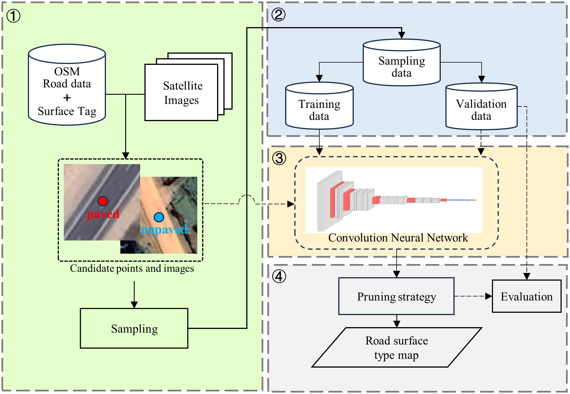
This study proposes a method for identifying road surface types through the integration of OpenStreetMap road data and high-resolution Google satellite imagery (Fig.1). Specifically, this research utilizes road surface type labels marked by volunteers in the OSM road data as prior knowledge and combines them with corresponding Google satellite images for the automatic generation of machine learning training samples. Subsequently, various convolutional neural networks are compared for their accuracy in identifying road surface types. The optimal network is selected for training, and the best model is applied to the images corresponding to sampling points on every road in Kenya, resulting in the creation of the road surface type dataset for the country.

Fig 1. The workflow of our approach.
Benefits of the Data
A dataset of road surface types in Kenya was developed in this study (Fig. 2). It was found that most roads in Kenya were unpaved, and the proportion of paved roads in the whole country was only 30%, mainly distributed in the southwestern region of Kenya. There was a significant difference in the road paving rate between urban and rural areas. The dataset and these findings can provide decision support for the Kenyan government departments to improve road infrastructure.
Moreover, a method for identifying road surface types based on OSM road data and high-resolution Google satellite imagery was proposed in this study. These data can be used for free, so the method may also be applied to other countries and regions to develop data products of road surfaces.
Lastly, identifying road surface information can help determine all-season roads and assess the SDG 9.1.1 indicator. The method of this study can provide data support for assessing this sustainable development indicator. It may also be possible to employ multiple datasets to explore the relationship between road surface type and its impact on road safety, energy consumption, as well as socio-economic development.

Fig 2. The road surface type map of Kenya.
Follow the Topic
-
Scientific Data

A peer-reviewed, open-access journal for descriptions of datasets, and research that advances the sharing and reuse of scientific data.
Related Collections
With Collections, you can get published faster and increase your visibility.
Data for crop management
Publishing Model: Open Access
Deadline: Apr 17, 2026
Data to support drug discovery
Publishing Model: Open Access
Deadline: Apr 22, 2026


Please sign in or register for FREE
If you are a registered user on Research Communities by Springer Nature, please sign in