Monitoring mangroves via remote sensing to increase climate change resilience
Published in Earth & Environment
Why we did this
Climate change is one of the most pressing issues that the world is facing with repercussions far beyond the coastline. Typical to other island states, Mauritius is very small in size and highly dependent on its coastal assets. Climate change not only affects the environment, but also the economy and livelihoods. Addressing climate change impacts in the island context therefore requires urgent action for building resilience and safeguarding island communities against externalities such as extreme weather events and sea level rise.
In this respect, mangroves have long been identified as an effective nature-based solution against coastal threats. Right now it is critical to understand the changing extent of mangroves due to the key role they play in carbon capture, biodiversity preservation and ecosystem services. In this paper we demonstrate how geospatial techniques can be used to monitor and manage mangroves in Mauritius to ensure concrete actions are taken to maintain and protect these coastal habitats for climate change resilience.
What we did
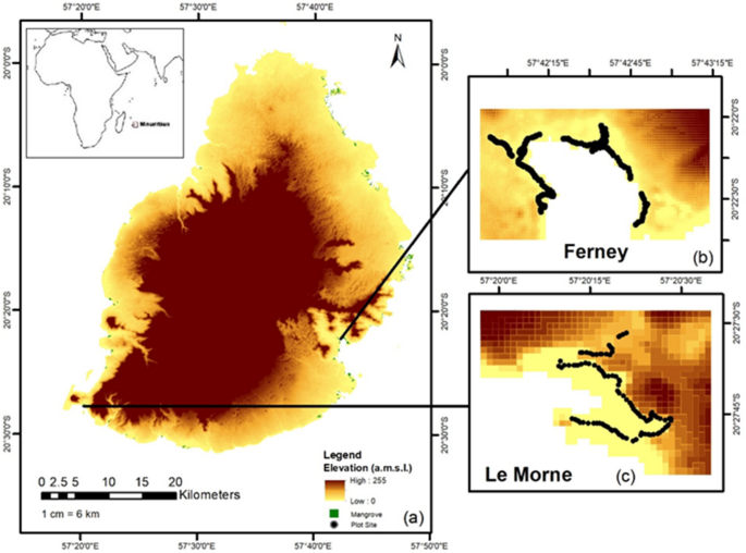
We selected two sites in Mauritius, namely Le Morne and Ferney, to undertake the analysis. Le Morne is in the south of Mauritius and active replantation is undergoing at the site. Ferney is one of the oldest mangroves found on the south east coast. We collected a total of 264 GPS points at both sites.


We then acquired freely available medium resolution satellite images for the years 2013 and 2023 to explore mangrove cover change. SPOT-5 image was retrieved for 2013 and Sentinel 2A for 2023. The images were pre-processed and spectral features were extracted with GIS software. Principal Component Analysis was conducted to remove redundant spectral data followed by Gray Level Co-Occurrence Matrices analysis on SNAP to characterise the texture of the images. The resulting outputs were stacked into composite images for supervised object based classification.
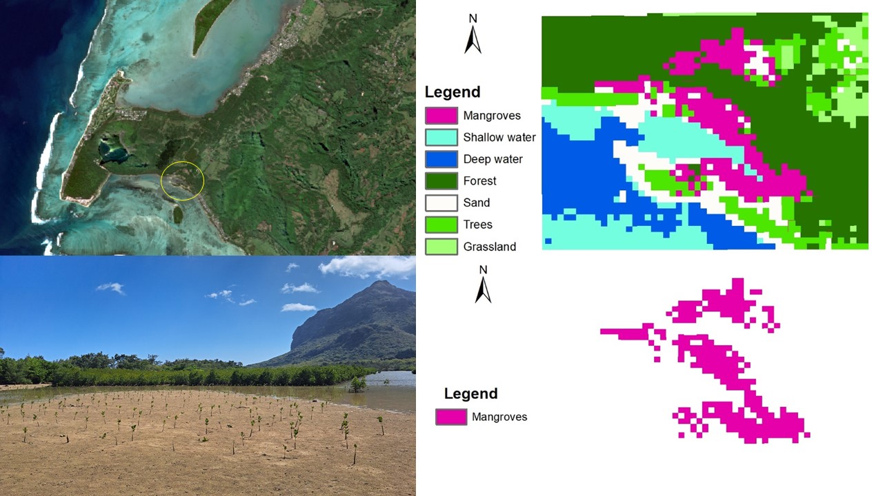
Different image classes were chosen as the images varied in terms of details. Thus for 2013 at Le Morne, the classes identified were mangroves, sand, mudflat, shallow water, grassland, forest and trees. The 2023 image was classified as mangroves, shallow water, deep water, forest, sand, trees and grassland. At Ferney, the 2013 image was classified as forest, mudflat, shallow water, deep water, settlements, agriculture, bare land, trees and mangroves. The 2023 image was classified as mangroves, agriculture, shallow water, deep water, settlements, bare land, forest and trees.
The model was then built using Random Trees, a similar algorithm to Random Forest, one of the most commonly used classifier in mangrove studies. The GPS points were used to train and validate the model using a 70-30% split. Error mask images where pixels were incorrectly classified in each class were calculated in a confusion matrix.
What we found
We found that both species of mangroves, Rhizophora mucronata and Bruguiera gymnorrhiza, that grow in Mauritius were present at the sites. Rhizophora was the dominant species though. At Le Morne, due to active plantation programmes, mangrove seedlings and young adults were growing in quadrats. Ferney as a mature forest had seedlings growing mainly in adjacent mud flats.
We found that mangrove cover increased from 0.06 ha in 2013 at Le Morne to 4.6 ha in 2023. We attribute this significant increase to active mangrove plantation activities at the site. At Ferney, mangroves also increased from 20.8 ha in 2013 to 26.3 ha in 2023. Here, we believe natural regeneration is taking place especially on fringing and surrounding mudflats. All images had kappa values of over 0.9 which are considered to be excellent agreement between observed and expected accuracy. At Le Morne, the kappa values were 0.91 and 0.93 for the classified 2013 and 2023 images respectively; for Ferney the kappa values were 0.94 and 0.91 for the classified 2013 and 2023 images respectively. The general confusion in modeling was seen to be between mangroves, forest and trees for all images.
The technique used in this study demonstrates how remotely sensed data when combined with GIS mapping tools can be an efficient technique to monitor mangrove change across landscapes. This can thereby provide invaluable insights, that could otherwise be unattainable, thus helping in informed decision making to increase climate change resilience.
 Mangrove distribution at Le Morne in 2013 based on SPOT-5 image classification (b) Mangrove distribution at Le Morne in 2023 based on Sentinel 2A image classification (c) Mangrove distribution at Ferney in 2013 based on SPOT-5 image classification (d) Mangrove distribution at Le Morne in 2023 based on Sentinel 2A image classification")
Classified mangrove cover at selected sites (a) Mangrove distribution at Le Morne in 2013 based on SPOT-5 image classification (b) Mangrove distribution at Le Morne in 2023 based on Sentinel 2A image classification (c) Mangrove distribution at Ferney in 2013 based on SPOT-5 image classification (d) Mangrove distribution at Le Morne in 2023 based on Sentinel 2A image classification
Why it matters
In general, for island nations including Mauritius, remote sensing analysis of ecosystems is still in its infancy due to several challenges such as the lack of human expertise and coding knowledge as required by platforms like Google Earth Engine. But if these challenges are addressed appropriately (as listed in our paper) remote sensing tools can be key in mapping mangroves, monitoring changes and extracting biophysical parameters for in-depth studies. Monitoring mangroves using remote sensing techniques can substantially increase a nation’s resilience to climate change. Remote sensing techniques can help support a number of mitigation and adaptation strategies including:
- Early detection of changes
- Vulnerability assessment
- Mapping coastal dynamics
- Carbon sequestration
- Community engagement
Overall, the study demonstrates the potential for practical, precise, repeatable and cost-effective assessment of mangrove distribution over time, offering reliable monitoring data to support management efforts.
Follow the Topic
-
Scientific Reports
An open access journal publishing original research from across all areas of the natural sciences, psychology, medicine and engineering.

Related Collections
With Collections, you can get published faster and increase your visibility.
Phytochemicals and health
Publishing Model: Open Access
Deadline: Jul 28, 2026
Health Policy and Systems Research
Publishing Model: Hybrid
Deadline: Jul 14, 2026


Please sign in or register for FREE
If you are a registered user on Research Communities by Springer Nature, please sign in