Open-Source Data Package Empowers Comprehensive Evaluation of US Energy Infrastructure Siting Challenges
Published in Social Sciences, Earth & Environment, and Research Data


Siting new electricity system infrastructure has many challenges in the US resulting from a combination of decarbonization goals, global warming impacts, technology advances, and socioeconomic change. To address these challenges, we need a comprehensive, exploratory modeling approach to evaluate power plant siting feasibility that includes alternative electricity system capacity expansion plans, as well as an understanding of key drivers. Until now, geospatial siting feasibility tools have had limited capabilities to meet these needs. Historical issues include the lack of: open source data/tools, geospatial suitability data in a standardized format for US-wide applications, and integration with capacity expansion planning models.
To fill these gaps, and with funding from the US Department of Energy’s Office of Science, the Pacific Northwest National Laboratory (PNNL) developed GRIDCERF (Geospatial Raster Input Data for Capacity Expansion Regional Feasibility). This open-source data package consists of 264 harmonized geospatial suitability rasters at 1 km2 resolution for the conterminous US. GRIDCERF addresses 56 different renewable and non-renewable power plant technology configurations and customizes siting suitability for each technology based on resource availability needs (e.g., cooling water, wind speed/height), land use constraints (e.g., wildlife preserves) and technology-specific siting needs (e.g., proximity to transportation infrastructure).
GRIDCERF includes logic to define a set of siting constraints common to all technologies as well as technology-specific restrictions that further demonstrate the complexity of power plant siting decisions. Figure 1 shows the default common suitability layer for all technologies and is a composite of 20 individual layers. Figure 2 illustrates the technology-specific suitability for conventional biomass power plants that use recirculating cooling without carbon capture and storage. This result combines the common suitability result from Figure 1 with five additional geospatial layers representing specific siting challenges for this technology (e.g., distance to airports, rail nodes, navigable waters, densely populated areas).
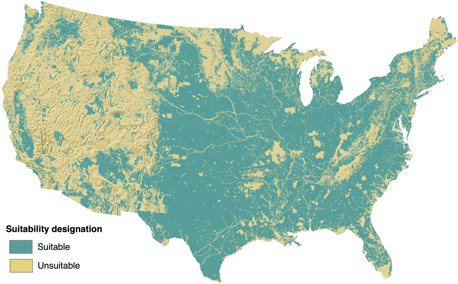
Figure 1. Map of the contiguous United States showing composite siting suitability of all common constraints
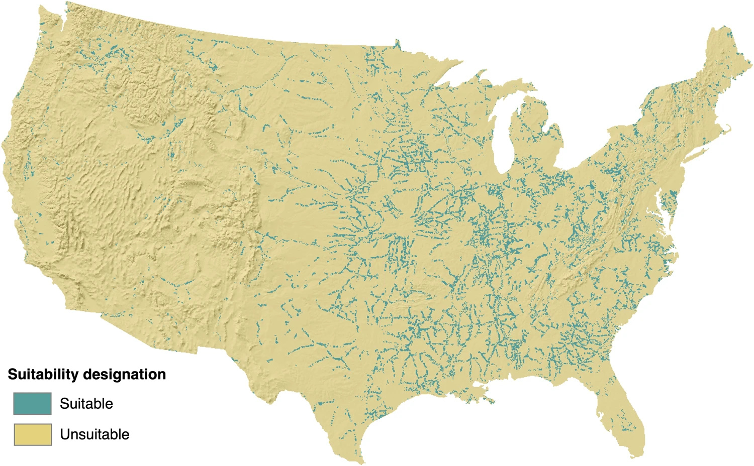
Figure 2. Map of the contiguous United States showing the composite siting suitability (common and technology-specific) for conventional biomass power plants that use recirculating cooling without carbon capture sequestration.
While it is a standalone data package that can be utilized in geospatial analyses and energy planning, we also designed GRIDCERF to work with the Capacity Expansion Regional Feasibility (CERF) open-source model. CERF translates coarse-scale capacity expansion plans into feasible, geolocated siting plans using an economic algorithm where technologies compete for GRIDCERF-determined suitable locations based on interconnection cost and energy value. The GRIDCERF data package is currently being used with CERF in several research projects at PNNL that are exploring the implications of alternative energy system transitions for landscape impacts, energy justice, and resource adequacy, including the Integrated Multiscale Multisector Modeling (IM3) and the Grid Operations, Decarbonization, Environmental and Energy Equity Platform (GODEEEP) projects.
Last, we are in the process of expanding GRIDCERF to address an even wider range of electricity generating technologies (e.g., offshore wind) and siting constraints. Please contact us through our GitHub site for additional information.
Follow the Topic
-
Scientific Data
A peer-reviewed, open-access journal for descriptions of datasets, and research that advances the sharing and reuse of scientific data.

Related Collections
With Collections, you can get published faster and increase your visibility.
Genomics in freshwater and marine science
Publishing Model: Open Access
Deadline: Jul 23, 2026
Genomes of endangered species
Publishing Model: Open Access
Deadline: Jul 01, 2026

Please sign in or register for FREE
If you are a registered user on Research Communities by Springer Nature, please sign in