Subsurface conditions and hydrologic accumulation drive stream connectivity and flow intermittency in urban river networks
Published in Earth & Environment and Ecology & Evolution

Motivation
During the first year of my Ph.D. studying urban river networks, I spent a lot of time getting to know the Little Calumet River Watershed (LCRW)- its land use, the layout of streams, and how different parts of the network are connected. As I spoke with my advisor and others familiar with the area, I kept hearing a curious remark: some segments of the network didn’t have flowing water all the time. Though this intermittence was a known feature, there was little understanding of which parts of the network experienced it, when it occurred, or what factors contributed to it.
This gap wasn’t just missing data; it was a missing piece of how the system functions. If we don’t know when and where streams are flowing, it’s hard to understand how sediments and nutrients travel, or how contaminants are transported. The literature offered insights from natural stream networks, but there was little guidance for urban settings. That uncertainty became my starting point: I wanted to observe the system directly, to uncover the hidden rhythms of urban river networks, and to understand the patterns behind their intermittence and connectivity.
Data collection
To observe these dynamics, we conducted 19 field surveys between May 2024 and April 2025, covering the entire 113 km² urban watershed. Across the network, we monitored 77 observation nodes. These surveys captured seasonal transitions from spring’s wet conditions into the drier periods of late spring and early fall. Additional surveys in October and November captured fall re-wetting, and a final visit in April 2025 documented early-spring snowmelt and rainfall.
To put it simply, this effort allowed us to observe how the same stream network behaves under a wide range of wet and dry conditions across both space and time.
Together, these observations allowed us to move beyond simply mapping the network to asking how it actually functions across space and time. Specifically, we asked:
- Will urban stream networks exhibit the same relationships with hydrological drivers that have been observed in natural catchments, or are those relationships altered or obscured by urbanization?
- Where these controls are evident, do they shift along gradients of impervious cover, reflecting the faster runoff and transport typically associated with urbanized landscapes?
Insights from an Urban Watershed
Within the highly urbanized LCRW catchment, the stream segments that were most frequently intermittent were located in the parts of the watershed with the least impervious cover. This pattern was unexpected. We initially assumed that the more developed portions of the watershed would be more prone to intermittence because impervious surfaces and engineered drainage networks are often thought to accelerate water export.
Instead, sustained flow was more common in developed areas, likely because of delayed drainage from ponding areas, infrastructure leakage, irrigation, and other urban sources. As a result, the spatial distribution of intermittence was not explained by impervious cover alone. Rather, soil permeability and underlying geology emerged as the key factors determining where flow persisted and where stream segments became intermittent.
If soil permeability and subsurface geology help explain where intermittence occurs among individual stream segments, antecedent weather conditions help explain when the river network as a whole becomes more or less connected. In particular, effective precipitation during the previous six days and the frequency of dry days were strong predictors of network connectivity. These relationships show that the urban network can expand and contract rapidly in response to recent weather conditions, more quickly than is typically expected in natural catchments.
Although these findings come from a single watershed, the LCRW shares documented similarities with 729 other U.S. catchments and reflects characteristics common to urban settings worldwide.
Broader implications
Overall, this study suggests that urbanization does not make stream behavior harder to understand. Instead, it provides a setting where patterns of connectivity are still structured and can be meaningfully interpreted.
These findings also refine how we think about headwater urban streams by showing how land use and watershed characteristics work together to control when and where flow emerges and how connectivity develops. More broadly, they offer a framework that can be applied in other cities, helping improve our understanding of how urban watersheds function and informing strategies for their protection.
A Lesson from the Field
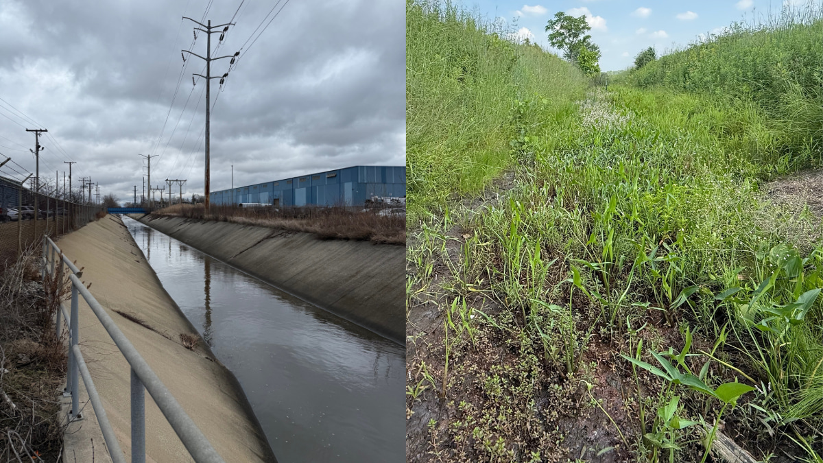
To close, I want to share a moment in the field that has stayed with me. During one survey, I had pulled over at a roadside crossing to take notes when someone asked what I was doing. I explained that I was surveying the river network. They looked at the narrow, concrete-lined drainage channel (mostly hidden by overgrown vegetation) and said, “That’s not a river.”
And in a way, they were right. It wasn’t the Mississippi. It was small, engineered, and easy to overlook. But it was still part of the river network.
That exchange captures something important. In cities, we often overlook these modest, altered channels because they don’t match our mental image of a “real” river. Yet rivers are networks, where every segment is dynamic and worth our attention.
For me, every time I drive past a culvert, I check whether water is flowing underneath; and those who have generously helped collect data with me say they’ve started doing the same. I invite you to try it too; you might be surprised by what you learn about your local river system.
Follow the Topic
-
Communications Earth & Environment
An open access journal from Nature Portfolio that publishes high-quality research, reviews and commentary in the Earth, environmental and planetary sciences.

Related Collections
With Collections, you can get published faster and increase your visibility.
Hazards in Mountain Regions
Publishing Model: Open Access
Deadline: Nov 02, 2026
Ecosystems under marine heatwaves
Publishing Model: Hybrid
Deadline: Oct 22, 2026


Please sign in or register for FREE
If you are a registered user on Research Communities by Springer Nature, please sign in