The Blue-Green Synergy: Discovering a Powerful Partnership for Cooler Cities
Published in Social Sciences, Earth & Environment, and Sustainability
Getting our paper, "Maximizing cooling benefits through urban green and blue spaces in Taipei city," accepted by *Discover Cities* was a moment of immense satisfaction. It felt like the culmination of a long journey that started not just with a research question but with a very palpable, personal experience: the increasingly sweltering summers in Taipei.
If you've ever walked through a dense city on a hot day, you've felt the Urban Heat Island (UHI) effect. The heat seems to radiate from the concrete, the asphalt, and the glass facades. Then, you step into a park or walk by a river, and you feel an immediate sense of relief. That visceral contrast was our starting point. We knew green and blue spaces cooled their surroundings, but as researchers, we had to move beyond feeling it to *measuring* it precisely. How much cooler? Does the size of a park matter? And what happens when you combine water and vegetation?
The Core Challenge: Pinpointing the Temperature
The foundation of any study on urban heat is accurate Land Surface Temperature (LST) data. While satellites provide this data, retrieving precise LST is notoriously tricky. Traditional methods are often constrained by atmospheric conditions and the complex interplay of land surface properties. We wanted a method that was not only accurate but also robust and reproducible.
This led us to our first major innovation: developing a *knowledge-driven deep learning model*. Instead of treating the AI as a black box, we "taught" it the physics. We fed our 1-Dimensional Convolutional Neural Network (1D-CNN) real LST data calculated from physical equations, alongside the satellite's spectral bands and vegetation indices. It was a marriage of domain expertise and cutting-edge AI. The "aha!" moment came when our model consistently outperformed other machine learning techniques. It wasn't just a statistical win; it felt like we had successfully encoded the complex reality of urban thermodynamics into a tool we could trust. This robust LST map became the bedrock upon which all our subsequent findings were built.
The Surprising Story of Shrinking Green Patches
With a reliable temperature map in hand, we turned to the green spaces. Using spectral mixture analysis, we meticulously mapped three decades of urban greenery in Taipei. The city-level trend showed positive efforts in greening, but the devil was in the details—or rather, in the sizes.
When we categorized green spaces by size, a concerning trend emerged. While the total number of small green patches (less than 0.1 hectares) was increasing—a testament to rooftop gardens, pocket parks, and roadside planting—the area covered by the largest green spaces (over 100 hectares) was significantly declining. This was a classic case of what we might call "green space fragmentation." The city was gaining many small, scattered cool spots but losing its large, powerful "cold islands."
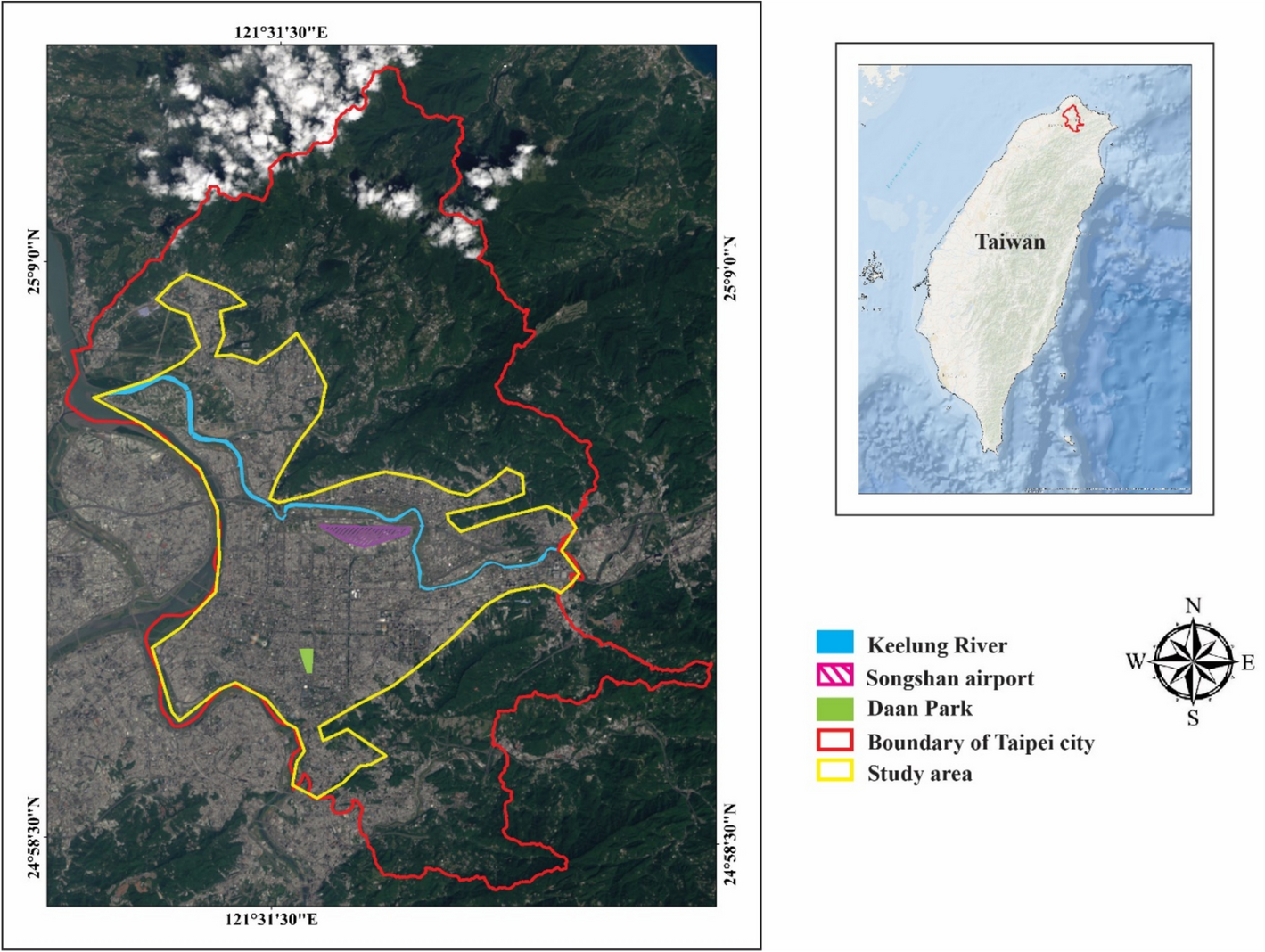
Our spatial regression analyses confirmed our suspicions. These large, contiguous green spaces—like Daan Forest Park, which we highlighted as a case study—had a profoundly stronger cooling effect than the sum of many small patches. A single large park acts as a cohesive cool air factory, while small, isolated patches struggle to influence their immediate surroundings against the overwhelming heat of the urban matrix. This finding was a crucial nuance for urban planners: it’s not just about *how much* green space you have, but *how it’s configured*.
The Blue-Green Synergy: A Cooler Partnership
Perhaps the most exciting part of our research was untangling the relationship between blue spaces (rivers, wetlands) and green spaces. It’s intuitive that a river cools the air, but we wanted to quantify it and see how vegetation enhanced this effect.
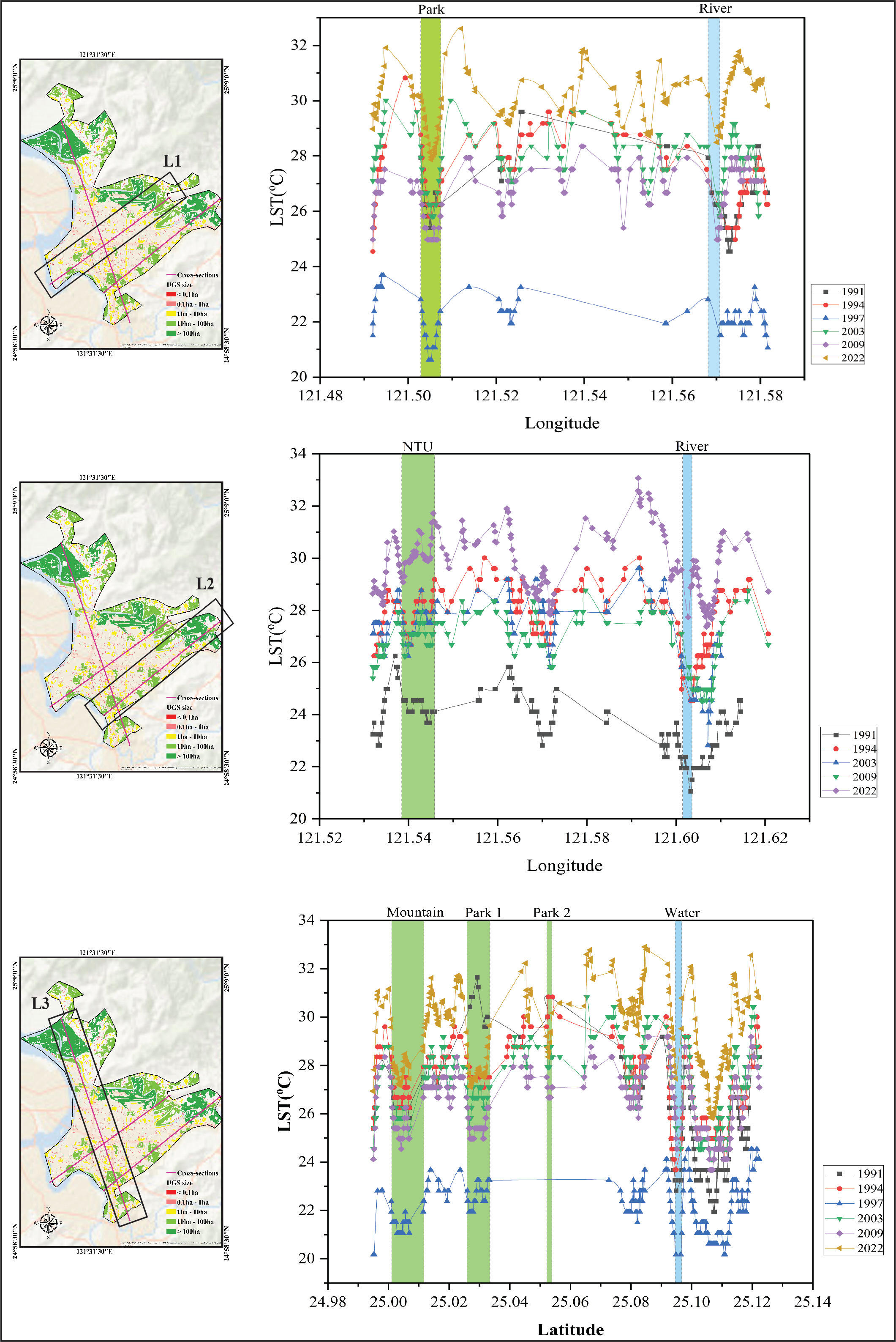
We developed a novel method to isolate the cooling effect of the Keelung River. By creating temperature profiles across the river and identifying the point where the cooling influence faded, we could calculate the "cooling temperature" attributable to the water itself. But the story didn't end there.
When we looked at the spatial patterns of "cold spots," we saw that the most potent cooling occurred where blue met green. A riverbank lined with vegetation was far more effective at reducing temperatures than a concrete canal. The combined cooling effect of blue and green infrastructure was greater than the sum of its parts. The vegetation, through shading and evapotranspiration, pre-cools the air before it interacts with the water, and the water body, in turn, helps sustain the moisture needed for the plants' cooling processes. It’s a beautiful, synergistic relationship that creates a much more resilient and extended cooling corridor.
This was a powerful insight. It argues against hard engineering solutions for waterways and champions the restoration of natural, vegetated riverbanks as a core climate adaptation strategy.
The Human Element and the Path Forward
This research was never just an academic exercise. It was driven by the real-world challenge of making cities more livable, especially for vulnerable populations like the elderly, who are disproportionately affected by heatwaves. Seeing the transformation of Daan Forest Park from barren land to a thriving urban forest—and correlating that directly with the emergence of a new "cold spot" on our maps—was incredibly rewarding. It was tangible proof that policy and planning decisions can, and do, alter the city's microclimate for the better.
Our journey, from feeling the heat to modeling it with AI, leads us to a clear set of messages for policymakers and planners:
**Prioritize Preservation:** Protect large, contiguous green spaces at all costs. They are non-negotiable assets for urban climate resilience.
- **Design for Connection:** When creating new green spaces, aim for size and connectivity. Cluster smaller patches and link them with green corridors to amplify their cooling power.
- **Embrace the Partnership:** Always integrate green spaces with blue infrastructure. Create "cooling corridors" along rivers and wetlands by preserving or restoring their natural vegetated buffers.
This paper is our contribution to the global effort to build more sustainable and climate-resilient cities. The methods we developed offer a replicable framework, and the findings provide actionable evidence. The summer heat in Taipei might have been our initial motivation, but we hope the cool logic of our findings will help cities everywhere breathe a little easier.
Follow the Topic
-
Discover Cities
This is a fully open access, peer-reviewed journal that supports multidisciplinary research and policy developments across the field of urban science.

Related Collections
With Collections, you can get published faster and increase your visibility.
Spatio-temporal Big Data: Enabling Urban Land Use and Climate Change for Sustainability
With the acceleration of global urbanization and the intensification of climate change, cities are facing unprecedented challenges and opportunities. Urban land use patterns not only directly affect the economic, social, and environmental sustainability of cities but also determine their adaptive capacity and resilience to climate change. Meanwhile, extreme weather events, rising temperatures, and sea-level rise brought about by climate change pose higher demands on urban land use and infrastructure. Therefore, how to address climate change through optimized land use and enhanced urban resilience has become a key issue for urban sustainable development.
In recent years, the rapid development of spatio-temporal big data technology has provided new ideas and tools for solving this complex problem. Spatio-temporal big data, encompassing various data sources such as Geographic Information Systems (GIS), remote sensing, Internet of Things (IoT), and mobile data, offers high-resolution and multi-dimensional spatio-temporal information. These data not only enable more precise monitoring and analysis of urban land use changes but also reveal the mechanisms by which climate change impacts urban systems. Moreover, combined with advanced analytical techniques such as machine learning, deep learning, and statistical modeling, spatio-temporal big data can provide scientific evidence for urban planning, policy-making, and resource management, thereby facilitating the achievement of urban sustainable development goals.
This collection aims to gather cutting-edge research findings on the application of spatio-temporal big data in urban land use and climate change, exploring how data-driven approaches can optimize urban land use, enhance urban resilience, and promote urban sustainable development. We welcome researchers from multidisciplinary fields such as geographical sciences, urban planning, environmental science, climate science, and data science to submit original research papers, review articles, and case studies to jointly advance the theoretical and practical development of this interdisciplinary field.
The research collected in this series includes, but is not limited to, the following topics:
1. Application of Spatio-temporal Big Data in Urban Land Use Monitoring and Assessment
- Land use change analysis based on remote sensing and GIS
- Modeling urban expansion and land cover changes using spatio-temporal big data
- Assessing and optimizing urban land use efficiency
2. Impact of Climate Change on Urban Land Use
- Impacts of extreme weather events on urban land use and corresponding responses
- Relationship between urban heat island effects and land use under climate change
- Effects of sea-level rise on land use in coastal cities and adaptation strategies
3. Application of Spatio-temporal Big Data in Urban Climate Resilience
- Urban flood risk assessment and management using spatio-temporal big data
- The role of urban ecosystem services in climate change adaptation
- Assessing and enhancing urban infrastructure resilience to climate change
4. Spatio-temporal Big Data and Urban Sustainable Development Planning
- Developing urban sustainability indicators using spatio-temporal big data
- Climate change adaptation in urban land use planning
- Synergistic optimization of urban transportation, energy, and land use
5. Interdisciplinary Research on Spatio-temporal Big Data
- Economic analysis of urban land use and climate change
- Social equity perspectives on urban land use and climate adaptation
- Spatio-temporal big data analysis of urban health and well-being
Keywords:Spatio-temporal Big Data; Urban Land Use; Climate Change; Urban Planning; Sustainable Development; Urban Economics; Machine Learning; Carbon Emissions; Ecosystem Services; Urban Resilience, Smart Cities
Publishing Model: Open Access
Deadline: Dec 30, 2026
Urban Futures: Strategies for Decarbonized, Resilient, and Equitable Cities
Cities stand at the forefront of the global sustainability challenge. This Collection explores how urban areas can become drivers of climate action, social equity, and systemic transformation. Drawing from contributions presented at the Urban Futures Symposium 2025 (hosted by the Urban Energy Systems Laboratory at Empa, Switzerland), this Collection brings together research, practice, and policy insights on how to build decarbonized, resilient, and equitable cities.
The articles cover a wide range of themes, including integrated urban energy systems, low-carbon mobility, participatory governance, just and equitable transitions, sufficiency-based planning, nature-based solutions, circularity, embodied emissions, digital urban innovations, financing and economics, and building and energy technologies. With case studies from cities across the Global North and South, and perspectives from both academic and practitioner communities, the Collection highlights interdisciplinary and cross-scale strategies for navigating urban complexity in a rapidly changing world.
We invite contributions that explore theoretical frameworks, empirical studies, modeling approaches, or co-designed solutions for shaping just, climate-compatible urban futures.
Keywords: Urban transitions; Urban resilience; Participatory urban planning; Justice, equity, and well-being; Urban governance and policy; Integrated energy systems and technologies; Sustainable mobility; Sufficiency strategies; Circular economy and resource flows; Materials and embodied emissions; Nature-based solutions; Urban ecology and environmental systems; Financing mechanisms and urban economics; Innovations in the built environment; Systemic innovation for urban sustainability.
This Collection supports and amplifies research related to SDG 11 (Sustainable Cities and Communities), SDG 7 (Affordable and Clean Energy), SDG 13 (Climate Action), SDG 12 (Responsible Consumption and Production), and SDG 10 (Reduced Inequalities).
Publishing Model: Open Access
Deadline: Dec 31, 2026

Please sign in or register for FREE
If you are a registered user on Research Communities by Springer Nature, please sign in