What Drives the Evolution of Submarine Canyons Toward the Italian Coasts?
Published in Earth & Environment

The Perspective
We have always found ourselves standing at a crossroads. Our academic journey has been a constant balance between quantitative morphotectonics, seismotectonics, and marine geology. However, connecting these three worlds has not always been an easy feat. Each field comes with its own steep learning curve, a specialized language, and a unique set of tools. Integrating them often felt like trying to bridge a gap between disciplines that, while physically adjacent, seemed worlds apart in practice.
We share a firm belief: we cannot truly understand the grand geophysical processes of our planet without an integrated land-sea vision. To grasp the full picture, we often need to flip our perspective, literally looking at the land from the sea, sometimes from the abyss!
The Giants Under the Waves
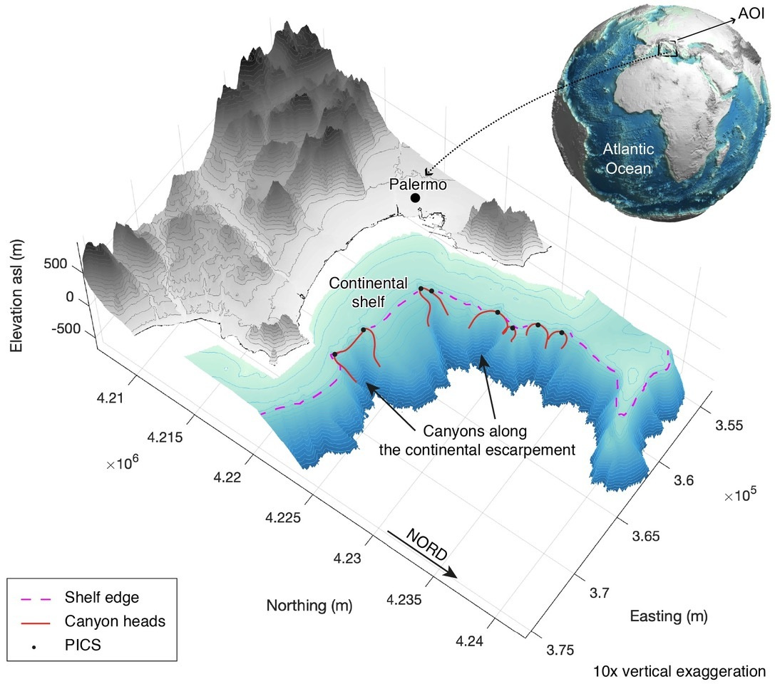
In peninsular Italy, and particularly in the southern regions, this perspective shift feels almost instinctive. When you turn your gaze away from the mainland and peer down into the deep sea, you realize that the most astonishing landscapes aren't necessarily the ones we see in the sunlight. Beneath the sea surface lie "landforms" that can be nothing short of gargantuan (Fig. 1).
We are talking about immense submarine valleys, named “submarine canyons”, that host complex meanders, sudden bathymetric drops, and slopes so steep they would be terrifying on land. In many cases, these features have a greater relief than the mountains, valleys and canyons we measure above sea level.
The spark for this research came from a moment of serendipity. While observing the bathymetric configuration of the Italian seabed, we noticed a strange pattern: in some areas, the underwater topography perfectly mirrored the landscape above; in others, the two differed significantly. This discrepancy raised a fundamental question: Why? What forces allow some canyons to stay "in sync" with the coast while others retreat or evolve independently?
Decoding the Abyss with AI
To solve this puzzle, we realized that traditional methods wouldn't be enough. We needed to find hidden relationships between independent datasets and, more importantly, we needed to quantify them. This is where one of the most fundamental tools of modern science came to our aid: Machine Learning.
By leveraging the massive availability of open-access data, we embarked on a journey to fuse three distinct "voices" of our planet:
- Voices from Space: Data from satellites orbiting the Earth, InSAR, EGMS and GNSS data, providing a high-resolution view of ground deformation.
- Voices from the Surface: seismological catalogs and geomorphological markers that capture the smallest vibrations and long-term crustal movements.
- Voices from the Abyss: Bathymetric echoes and geomorphological mapping that reveal the hidden scars of the seafloor.
Integrating these datasets was a challenge. As shown in our supplementary notes, we had to move from raw data to complex statistical transformations (Quadratic, Logarithmic, and Square Root models) to find the "best fit" for variables like the horizontal strain rate or the uplift rates from paleoshorelines.
Why It Matters
Our study reveals that submarine canyon retreat isn't just a random underwater event; it is a response to the "pulse" of the Earth. Active tectonics and the proximity of river mouths are the primary drivers of this susceptibility.
For a country like Italy, where the majority of the population lives near the coast, understanding these underwater giants is not just an academic exercise. It is a necessity for coastal planning and hazard mitigation. Submarine canyons are the "highways" of sediment transport from the coast to the deep ocean, and their stability (or lack thereof) has direct implications for coastal erosion and infrastructure.
Looking Ahead
Writing this paper was a journey through different scales and environments. It taught us that the most profound insights often come when we step out of our specialized silos. By combining "the echoes of the depths" with "the eyes in the sky," we’ve started to build a bridge across that shoreline gap.
We hope our work inspires other researchers to embrace this integrated vision. Sometimes, to understand the ground you stand on, you simply need to take a deep breath and look at it from the bottom of the ocean.


Please sign in or register for FREE
If you are a registered user on Research Communities by Springer Nature, please sign in