What science is ahead for the Zhurong Rover in Utopia Planitia?
Published in Astronomy

After a series of successes in lunar exploration, the Chinese National Space Administration (CNSA) set its sights on the "Fire Planet" (火星) with an ambitious orbiter-rover mission. Nearly 3 months after arriving at Mars, the orbiter Tianwen-1 released the rover Zhurong, which made history on May 14th 2021 by landing safely in the plains of Utopia Plantia.
The exact location of the rover will be determined later using various techniques. Images captured Zhurong itself during its decent will be compared to images captured from orbit showing the landscape of the site. Also, the NASA instrument HiRISE might be able to image the rover on the surface sometime soon, showing the exact location of the hardware on the surface. Until then, engineers rely on radio data to estimate the location and using those data, it seems the rover is located near 109.9E, 25.1N – near the centre of the images below.
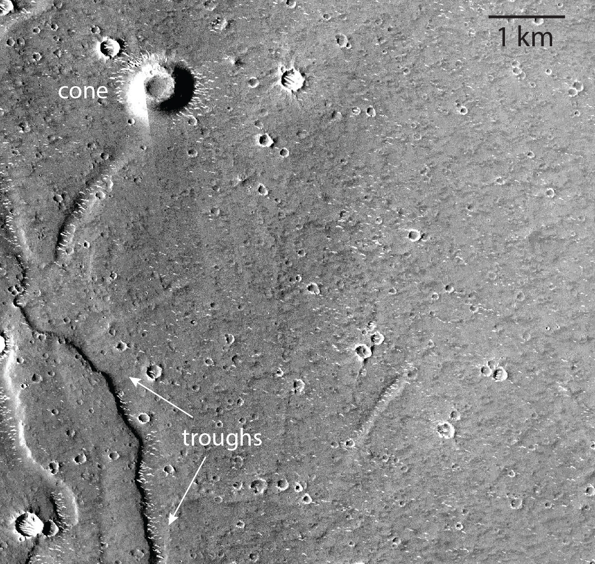
Figure 1 below shows some interesting features of the landing site. The best currently available images of the landing site come from NASA’s Mars Context Imager (CTX), which have a spatial resolution of about 6 meters per pixel. CTX data of the landing region show a number of interesting features, including smooth plains cut by shallow cliffs and troughs (on the west side of this image) which define the outline of “polygonal terrain” thought to form in association with ice. The small hill in the top-left of the image has an unknown origin, but it is very likely either a small volcano or a mud volcano. Utopia Planitia has many candidate mud volcanoes and the extraordinary possibility of exploring one with this mission is undeniably one of the most exciting scenarios.

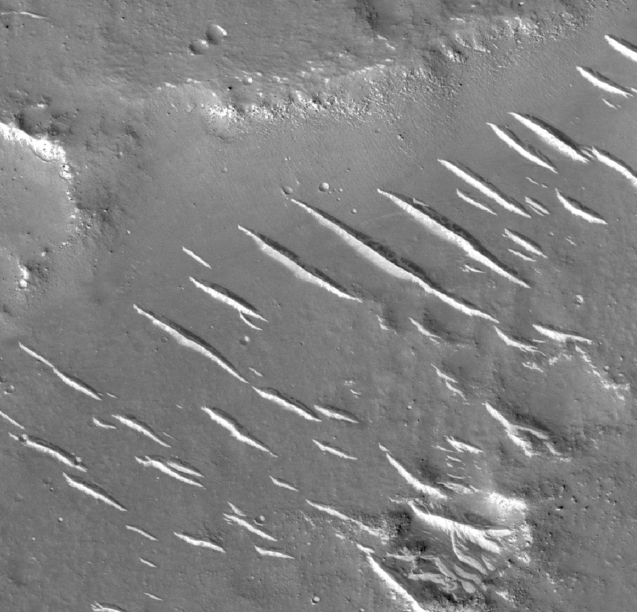
Tianwen-1 is equipped with a high resolution imager capable of ~2 meter/pixel spatial resolution, but Tianwen's High Resolution Camera (HRC) images are not yet publicly available as it is still early in the mission. The highest resolution images of the Martian surface come from the HiRISE instrument, which has been in orbit since 2005 and can produce images of approximately 30 cm/pixel. But these images must be targeted and only cover a small fraction of the planet. Therefore there are not currently any HiRISE images of the landing site because the spacecraft only landed days ago. However, we do have data from HiRISE corresponding to terrain that is in the same geological material, albeit 10s of km to the southeast (Figure 2).
Figure 2 shows a relatively smooth surface composed of granular materials and dust, with some prominent ridges - either linear dunes or yardangs, which are linear ridges of poorly consolidated wind-blown material. Such landforms are found in windswept deserts on Earth. The image also shows bedrock exposed in gentle, eroded and topographically muted cliffs that make up boundaries of what is called polygonal terrain characteristic of the Utopia region. The eolian landforms, shallow cliffs and smooth surfaces with occasional blocks of rock seen in this image are likely representative of the landscape the rover will encounter.

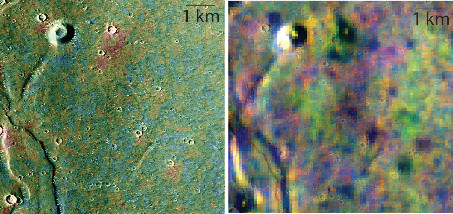
Some other remote sensing data from spacecraft currently orbiting Mars provide additional insights into the nature of landing area. Figure 3 shows infrared emission data from the Thermal Emission Imaging System (THEMIS) instrument onboard NASA's Mars Odyssey spacecraft. THEMIS measure radiance emitted from the surface providing both temperature maps and a way to investigate mineralogy using vibrational absorptions that occur in essentially all minerals and natural glasses.
By measuring how the temperature of the surface changes between nighttime and daytime, scientists can compute a value of thermal inertia - or the natural resisitance to temperature change in a material. Think of the "urban heat island" scenario where more and more concrete retains heat better than natural soil and green space. The concrete has higher thermal inertia and it stores up heat day after day, and it will remain warm during the nighttime making urban areas unnaturally hot. On Mars, dusty and sandy areas made of fine-grained materials will have low thermal inertia values (~200-300) and rocky surfaces will have high values (~600-800) at the scale of the THEMIS measurements (Fergason et al., 2006). Materials in the Zhurong's landing region have thermal inertia values of ~300-400, suggesting the rover will likely encounter plains of granular materials with some blocks of rock exhumed and ejected by the hundreds of small impact craters in the area. In Figure 3, I show nighttime temperature values instead of thermal inertia, but nighttime temperature is actually a good proxy for thermal inertia.
The image on the right in Figure 3 is also from THEMIS, but this is a multispectral daytime infrared image showing compositional differences as color variation. In this spectral combination, basaltic volcanic materials are generally blue-purple and alteration minerals formed by water appear yellow. It is not possible from these data to determine the exact minerals present, but it is encouraging to see that there are probably multiple compositional units in the landing region.

Why land the spacecraft in Utopia Planitia?
Utopia Planitia was chosen as the landing region for several reasons. One obvious reason is related to engineering. The site is relatively safe and flat, which was desirable to facilitate to safe landing. People say there is no such thing as "minor surgery" and a similar truth holds in space exploration: there is no such thing as a routine space mission. Without a safe landing, there are no scientific questions to answer. This site was chosen to help maximize success, and that strategy has proven to be a smart one.
The other reasons Utopia Planitia was chosen as the landing area are scientific in origin. For one, all of Utopia lies topographically below hypothesized shorelines of an ancient ocean (Citron et al, 2018). The question of whether the northern plains of Mars contained an ancient ocean is a complex one, with various pieces of evidence in some contradiction with each other. The story is an interesting one, but it is beyond the scope of this article. Most importantly, it is critical to point out that scientists generally do not expect to find seafloor deposits at this landing site because regardless of whether there was an ancient ocean covering this area or not, there has certainly been significant more youthful geological activity that has covered it up.
Younger geologic processes certainly have included volcanism. In fact, Mars is a volcanic planet and most of the surface has been covered by lava and ash with a bulk composition similar to the basaltic rocks found in Hawaii or Iceland. It is also true that most of the volcanic materials covering Mars have been modified by other geologic processes, and that is true in this case as well. In Utopia Planitia, it seems that the surface has been churned up by a broad category of processes that can be lumped together and referred to as periglacial processes. In other words, the surface has been modified by ice-related processes similar to what occurs in northern Canada or Siberia.
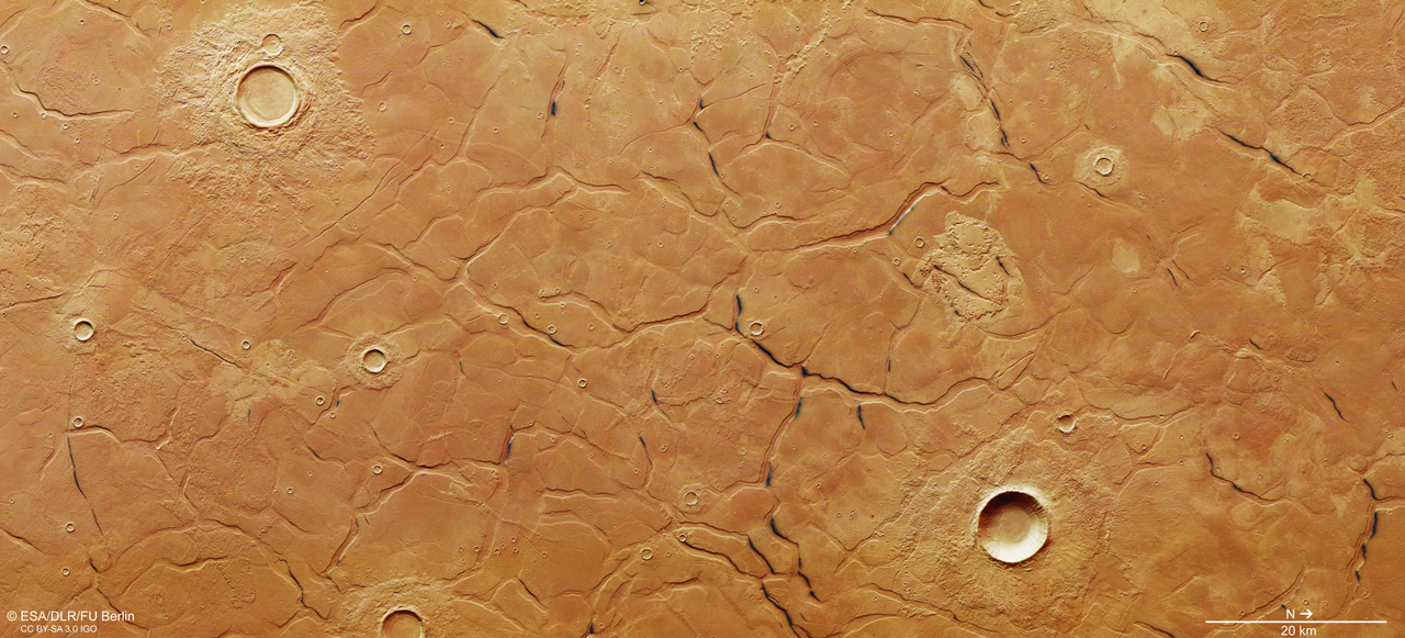
One striking element of the periglacial nature of this terrain is the presence of patterned ground containing polygonal fractures (see the topmost "poster" image of this article returned from ESA's High Resolution Stereo Camera or HRSC showing polygons in Utopia Planitia). These patterns are though to form by sublimation of subsurface water ice.
In fact, there is strong evidence for subsurface ice in Utopia Planitia. Aside from inferring its past existence from geomorphology or the presence of certain landforms, we can also search for its presence in the present day using radar. Indeed radar measurements show evidence for abundant subsurface ice present throughout Utopia, perhaps >14,000 km3 (Sturman et al, 2016). The significance of water ice currently existing in the subsurface goes far beyond pure scientific curiosity. In fact, accessible water ice on Mars is like finding a gold mine of sorts on Earth though the economics are totally different. The point is that all future human exploration or Mars will rely on our ability to mine water resources robotically in advance of a human landing. H2O will not only be used to support astronauts and hopefully a future space colony, the water will be split into its fundamental components which can then be recombined as rocket fuel. Rocket fuel for a return to Earth is far to heavy to bring with, so it will have to be made on Mars.
An additional scientific enigma of the Utopia Plantia region is the possibility of mud volcanism. The concept is what it sounds like...flows and cones are formed by eruption of mud rather than lava - in fact there need not be any sort of magma involved. Mud volcanism is caused by the diapiric rise of less dense muddy slurry which can originate through a number of processes. If it occurred in Utopia, it was possibly caused by exertion of pressure in the subsurface due to freeze-down. In this way, all known geological processes in the region might be linked up: a) the region might have or not have been an ancient ocean but it was b) resurface by volcanism and c) sequestered a lot of ice in the subsurface which resulted in d) alteration and extrusion of muddy, altered materials. Even at low temperatures, small amounts of fluids within ice can dramatically alter minerals (Niles et al., 2017). The altered sediments might expand due to hydration or otherwise become pressurized and ultimately be expelled to the surface.
A speculative but not unthinkable hypothesis relates to microbial life. On Earth, mud volcanism is often associated with methane outgassing and the production of methane is sometimes linked to microbial activity in the subsurface (e.g. Niemann et al., 2006). Though the idea of modern day life on Mars is a controversial one, the facts remain that: 1) methane periodically occurs in the Martian atmosphere inexplicably, 2) mud volcanism often associated with methane outgassing seems to have occurred in the landing site area, and 3) the modern subsurface of Mars is habitable from a energy-water-porosity standpoint (Tarnas et al., 2021). It is unlikely that mud volcanism is occurring today, but nonetheless, exploration of surface materials and expelled subsurface materials in the landing site area presents an opportunity for groundbreaking discovery by Zhurong and its excellent science team.
What are the big science questions and how will Zhurong help answer them?
The Zhurong Rover carries with it a scientific payload that will be able to test some of the big science questions outlined above. One of the most direct ways its observations might affect planetary science is by searching for subsurface ice in-situ using a ground penetrating radar. This instrument will be able to resolve boundaries in fundamentally different types of materials such as ice, empty pore space and rock/soil. The Mars Surface Compound Detector (MCSD) will be able to quantify surface chemistry and characterize spectral absorptions in minerals. A big question that can be addressed is whether the ice-mediated periglacial processes have led to aqueous alteration of volcanic protoliths. Many people assume that periglacial processes only lead to physical cracking and comminution of rocks (not chemical alteration), but when we look closely at minerals altered within Antarctic ice, we see evidence for intense alteration (Baccolo et al., 2021). Do we see altered minerals in the periglacial volcanic plains of Utopia Planitia? If the rover can travel far enough, it might be able to visit the edge of cliffs and troughs associated with polygonal terrain, revealing fundamental new insights into how periglacial processes have operated on Mars. One of the most audacious goals and one that would produce paradigm-changing science would be to visit possible mudflows erupted from the subsurface. By investigating the texture, chemistry and mineralogy of these deposits, we could learn fundamentally new information about some of the most profound scientific questions facing planetary scientists.
References:


Please sign in or register for FREE
If you are a registered user on Research Communities by Springer Nature, please sign in