Where is Mars shaking? We point at the southern edge of Tharsis!
Published in Astronomy

Explore the Research
 sciencedirect.com
ScienceDirect
About ScienceDirect Shopping cart Contact and supportTerms and conditionsPrivacy policy
The InSight mission of NASA has shown that Mars is still seismically active. During more than four years of operation (2019-2022), the probe’s seismometer SEIS had detected a total of 1,319 marsquakes of various magnitudes, which have significantly helped to improve our understanding of the red planet's internal structure. However, one particular area, in which the presence of marsquakes is assumed, but it was essentially impossible to detect unambiguously, is Tharsis, the largest volcano-tectonic province on Mars.
When Tharsis, a ~5,000 kilometres wide and up to 7 kilometres high bulge, formed, it deformed the surface of Mars and caused the cracking of martian crust. Since it would take a long time for the Martian subsurface to cope with the enormous load of Tharsis, it is possible that the surface may crack in Tharsis and its surrounding to this day, giving rise to Marsquakes.
One reason for the difficulty to locate marsquakes in that region is that Tharsis' position relative to InSight is in the shadow of the planet's large core, so any marsquakes in Tharsis would have escaped detection by SEIS. The search for recent traces of tectonic activity in Tharsis needs therefore to be done differently – as we are showing in our new study published in Icarus – by using remote sensing datasets that enables the identification of surface deformations possibly associated with the formation of marsquakes.
Based on high resolution images taken by the HiRISE camera onboard the Mars Reconnaissance Orbiter, me, Bartosz Pieterek from the Polish Geological Institute – NRI and Ernst Hauber from German Aerospace Center (DLR) studied the south-eastern part of Tharsis, an area named Claritas Fossae. This region is dominated by a prominent topographic scarp, Claritas Rupes, which is several hundred kilometres long and up to 2-kilometres high. Superposed on this huge tectonic feature, which was formed more than 3 billion years ago, we discovered a group of much smaller scarps with lengths of hundreds of meter-long and maximum heights of a few meters, which show a clear association with present-day rockfalls.
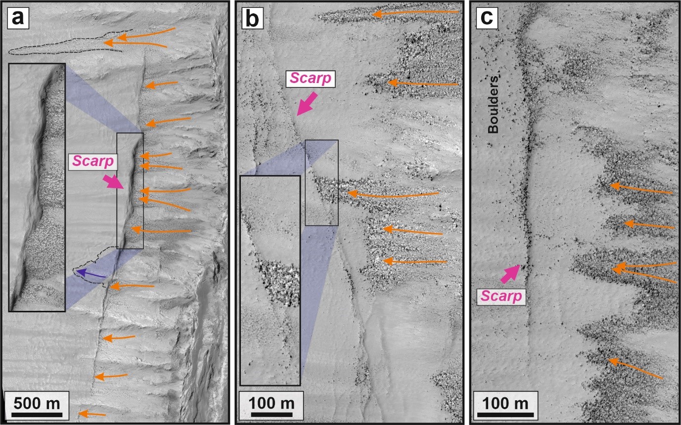
Examples of fresh-looking scarps mapped within the studied region at the Claritas Rupes scarp that stopped and accumulated boulders along their strike. Orange solid lines with arrows indicate the downslope direction of boulder movement.
To our surprise, these uphill-facing scarps were not covered by boulders and other debris from rockfalls that occur on steep slopes higher up on the main rupture of Claritas Rupes. Earlier studies suggested that the tectonic activity in this area had ceased around two and a half billion years ago, but our discovery shows that these small uphill-facing scarps have to be young. Very young!
We do not know for sure when exactly these uphill-facing scarps were formed, but in geological terms, they have to be “young” as they are associated with, and partly younger than present-day surface processes. We concluded that they are probably less than about one million years old. This is because if they were older, they would be already covered by rocks that are constantly falling down the main Claritas Rupes scarp. Hence, we might witness an unexpectedly young tectonic activity in this part of Mars.
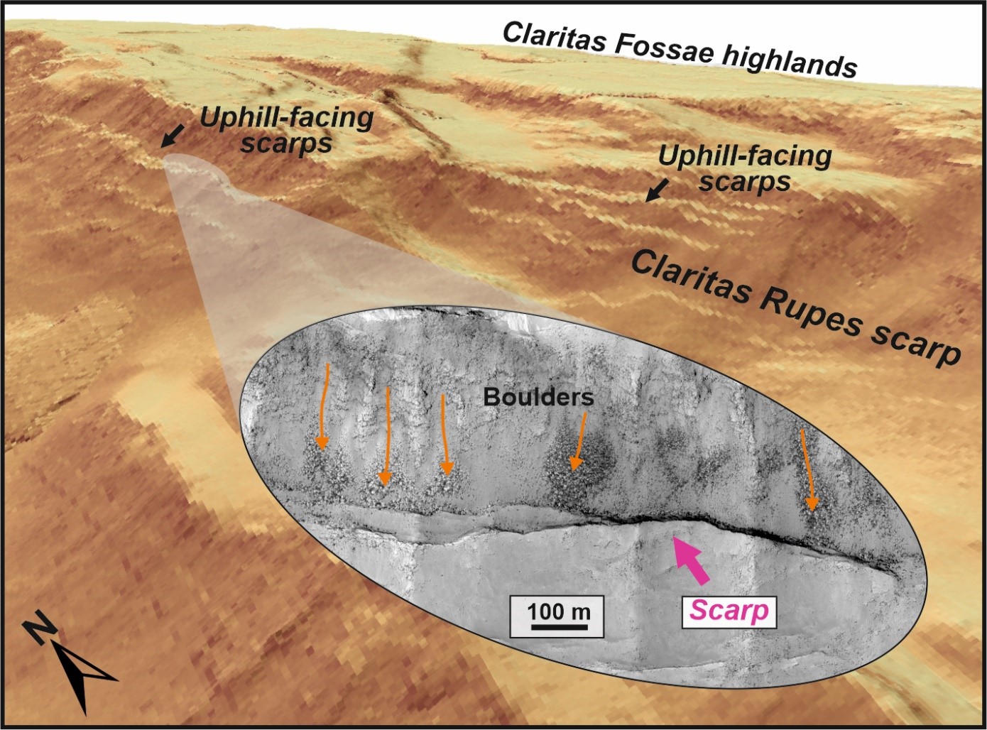
A 3D view of the major Claritas Rupes scarp which hosts clusters of pristine uphill-facing scarps. The zoom-in HiRISE-based image shows the accumulations of downslope moving boulders stopped by the scarp.
So far, only few morphologically pristine tectonic structures have been found elsewhere on Mars. The most famous pristine tectonic structures were described from Cerberus Fossae region located in Elysium Planitia. In connection with these structures, evidence of tectonic activity has been demonstrated - InSight detected several strong marsquakes in association with them.
Our work shows that both regions, Cerberus Fossae and Claritas Fossae, might host some of the youngest tectonic activity on Mars. But unfortunately, until another seismometer is placed on Mars that can detect marsquakes in Tharsis, we can not be sure if uphill-facing scarps in Claritas Fossae region are active even “at the moment” or not. For further research on the tectonic activity of Tharsis, we are left at the moment with image analysis as the only way to find their traces.
As shown, a lot about the recent tectonically active centers associated with Tharsis can still be learned. But to be able to do that, those of us who are interested in Mars exploration, need to have the ability to acquire very high-resolution images of the surface.
This is a critical for a better understanding of the planet’s evolution, and selecting the most promising sites on Mars for further studies. And as the American high-resolution camera HiRISE gradually degrades, we are in danger of losing that option. It is therefore appropriate to prepare and send a successor to take over its function.


Please sign in or register for FREE
If you are a registered user on Research Communities by Springer Nature, please sign in