Where the Tibetan Plateau could grow no further
Published in Earth & Environment
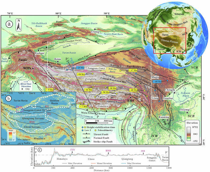
If you look at a topographic map of the Tibetan Plateau, one feature immediately catches your attention. The plateau is not symmetric.
To the east, it stretches for more than a thousand kilometers, gradually merging into the mountains of eastern Tibet. But toward the northwest, the plateau narrows dramatically before running into the southern margin of the Tarim Basin—one of the oldest, coldest and strongest continental blocks on Earth.
That simple observation became the starting point of our study. How did the northwestern Tibetan Plateau form? And perhaps more intriguingly, what happens when one of Earth's largest mountain belts grows toward a rigid continental craton that simply refuses to deform?
A missing piece of the puzzle
Over the past decade, remarkable progress has been made in reconstructing when different parts of Tibet reached high elevations. New paleoaltimetry, thermochronology and geodynamic studies have fundamentally changed our understanding of plateau growth, revealing that the Tibetan Plateau did not rise everywhere at the same time. Instead, different regions experienced remarkably different uplift histories.
Yet one conspicuous gap remained.
The northwestern interior of the plateau, the western Songpan-Ganzi terrane, already forms part of today's vast high-elevation, low-relief landscape, but its Cenozoic evolution remained surprisingly poorly constrained. Compared with regions farther east, very little was known about when this part of the plateau actually became incorporated into the Tibetan Plateau. For us, this missing piece was especially intriguing because of its tectonic setting. Unlike most other parts of northern Tibet, the western Songpan-Ganzi terrane lies directly against the Tarim Craton. This immediately raised a broader question that extends well beyond Tibet itself: how does a growing orogenic plateau interact with a rigid continental block?

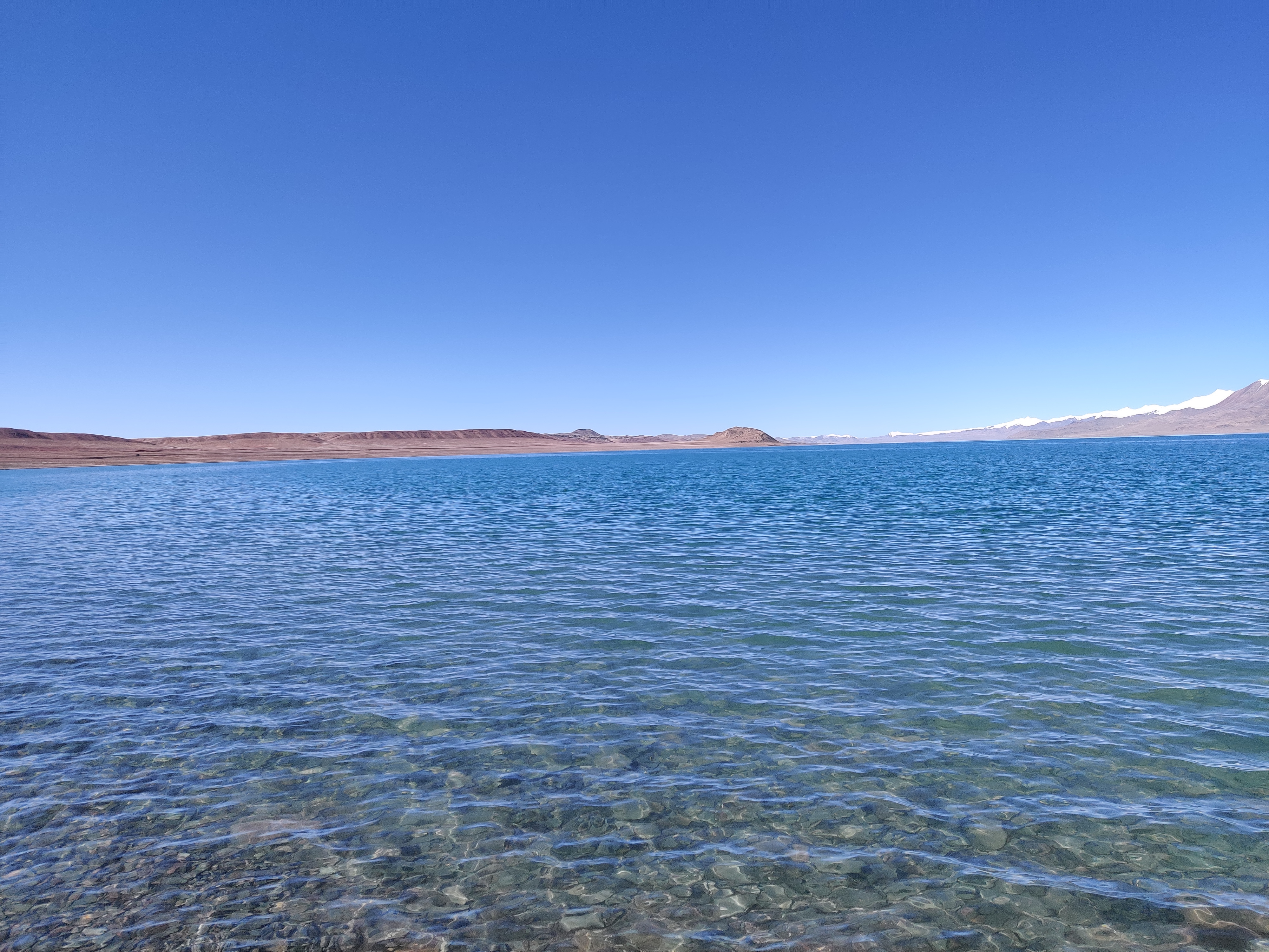
Hehribaé Tso, our main study area in the northwestern Tibetan Plateau. Today it forms part of the vast high-elevation, low-relief plateau interior, one of the last major regions where the timing of plateau growth remained poorly understood.
Into one of Tibet’s most remote landscapes
Answering that question required going somewhere that relatively few geologists have the opportunity to visit.
Our study area lies deep within the remote northwestern Tibetan Plateau. Large parts of the region are essentially uninhabited, with very limited road access. During the summer of 2021, Prof. He Wang and Dr. Zhenhong Wang organized an ambitious field campaign involving six off-road vehicles that crossed the Altyn Tagh Mountains before reaching our field area near Hehribaé Tso. The team established a temporary field camp and spent nearly a month working across this remarkable landscape.
Some of the most memorable days were spent in the Keliya region. Reaching several sampling sites required hiking more than 20 km in a single day, all at elevations exceeding 5,000 meters above sea level. At that altitude, every kilometer feels considerably longer than it does on a map. By the end of the expedition, everyone appreciated that every rock sample had truly been earned.
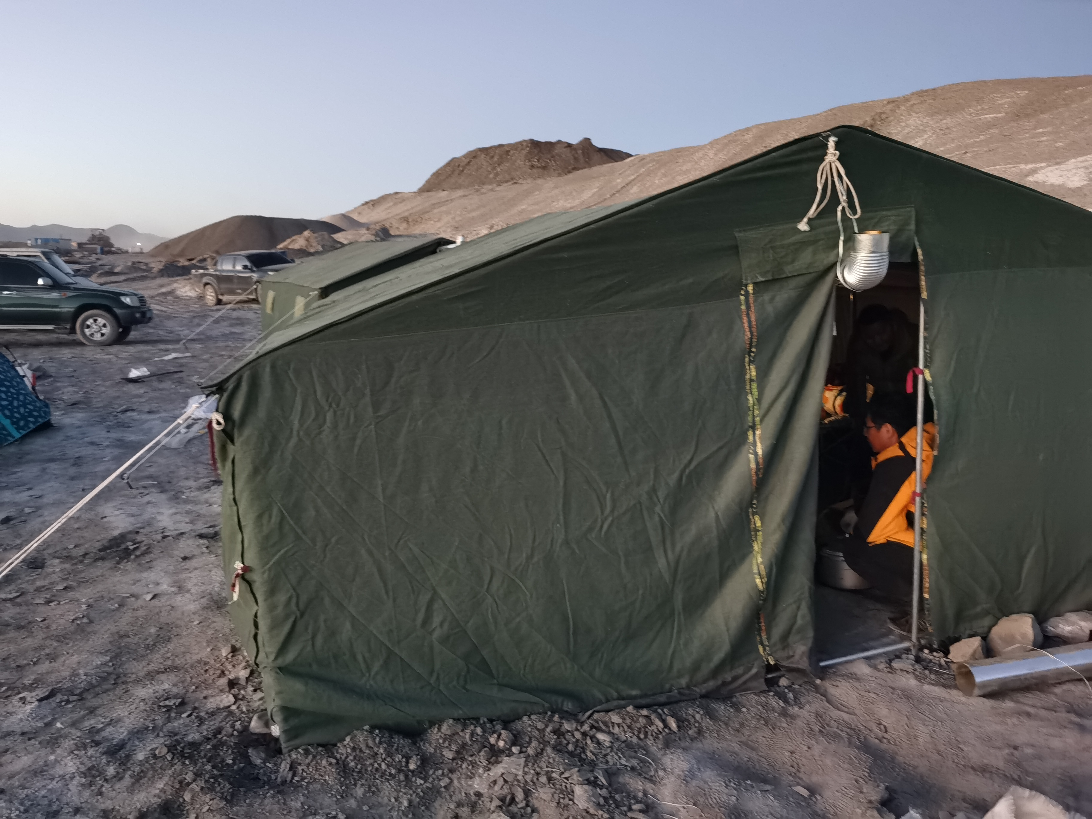
Our field camp near Hehribaé Tso. Reaching the study area required crossing the Altyn Tagh Mountains, after which our team spent nearly a month living and working in one of the most remote parts of the Tibetan Plateau.
The challenge continued in the laboratory
Collecting the rocks, however, was only the beginning.
As someone who has worked on low-temperature thermochronology for many years, I knew that Tibetan apatites often contain relatively low track densities. That creates a frustrating problem: after conventional laboratory preparation, many samples simply do not contain enough confined fission tracks for thermal history modeling. Without sufficient track-length measurements, reconstructing detailed cooling histories becomes much more uncertain.
Rather than accepting this limitation, we decided to take an additional, and rather uncommon step. In 2022, extra apatite mounts were sent to two laboratories on opposite sides of the world. At The University of Adelaide, the samples underwent 252Cf irradiation, while at the GSI Helmholtz Centre for Heavy Ion Research in Germany they were treated using heavy-ion bombardment. These specialized irradiation techniques generate additional artificial tracks that greatly increase the number of measurable confined tracks after chemical etching. The process required considerable extra time, coordination and patience, but it ultimately increased the number of measurable confined tracks by roughly four to five times. Those additional data became essential for constructing reliable thermal history models.
What the rocks revealed
When all the pieces finally came together, the rocks told a surprisingly coherent story.
Most of the cooling, and therefore most of the tectonic exhumation in our study area, occurred during the late Eocene to Oligocene. Afterwards, the northwestern plateau interior experienced relatively little additional exhumation, suggesting that this region had already evolved into the broad, high-elevation, low-relief landscape that characterizes much of northern Tibet today.
At the same time, deformation did not simply stop. Instead, it migrated toward the plateau margin, where younger thermochronological ages record continued mountain building in the West Kunlun Mountains. In other words, while the plateau interior had become comparatively stable, active deformation continued farther north.
A new way of thinking about plateau growth
Placing these observations into a broader regional framework led us to propose a simple working hypothesis.
Rather than behaving uniformly along its northern margin, the Tibetan Plateau appears to have responded differently depending on the tectonic boundary conditions. In the northwest, the rigid Tarim Craton likely acted as a mechanical buttress, concentrating crustal shortening and promoting relatively early plateau growth. Farther east, however, deformation was more effectively accommodated by large strike-slip fault systems and clockwise block rotation, allowing uplift to occur later and in a different manner.
This framework remains a working hypothesis rather than a definitive tectonic model. Nevertheless, it highlights an idea that may apply well beyond Tibet itself: the growth of large continental plateaus is strongly influenced by the mechanical properties of the neighbouring lithosphere. Rather than a single, universal mechanism, different parts of the Tibetan Plateau may have followed distinct tectonic pathways because they experienced fundamentally different boundary conditions.
Many questions still remain
Like most scientific studies, our work answers some questions while raising many others.
How exactly does the Tarim Craton interact with the surrounding mountain belts? Does convergence involve only crustal shortening, or also localized indentation, lithospheric underthrusting and multi-level lithospheric decoupling? Why do neighbouring mountain belts such as the Tianshan appear to deform so differently in their upper and lower crust? And how efficiently do the surrounding foreland basins absorb and redistribute tectonic stresses? Addressing these questions will require new field observations, increasingly detailed geophysical imaging and advanced numerical modeling.
The Tibetan Plateau remains Earth’s greatest natural laboratory for understanding continental deformation. By filling one of the last major gaps along its northwestern margin, we hope our study contributes another piece to this fascinating geological puzzle—and we are certain that many more discoveries still await.
Zhiyuan He (PhD, MSc, B.Eng) is a structural geologist and thermochronologist. He studies lithospheric and crustal deformation of the orogenic belt by using structural analysis and thermochronological dating methods. He is also interested in surface processes like erosion, sedimentation and transport, and thermal structure of the upper crust. For the last 8 years he has worked on the geology of Central Asia, Tibetan Plateau, and North China.
Follow the Topic
-
Communications Earth & Environment
An open access journal from Nature Portfolio that publishes high-quality research, reviews and commentary in the Earth, environmental and planetary sciences.

Related Collections
With Collections, you can get published faster and increase your visibility.
Hazards in Mountain Regions
Publishing Model: Open Access
Deadline: Nov 02, 2026
Ecosystems under marine heatwaves
Publishing Model: Hybrid
Deadline: Oct 22, 2026


Please sign in or register for FREE
If you are a registered user on Research Communities by Springer Nature, please sign in