A new Machine Learning Approch for Landslide suspectibility Mapping
Published in Social Sciences and Earth & Environment
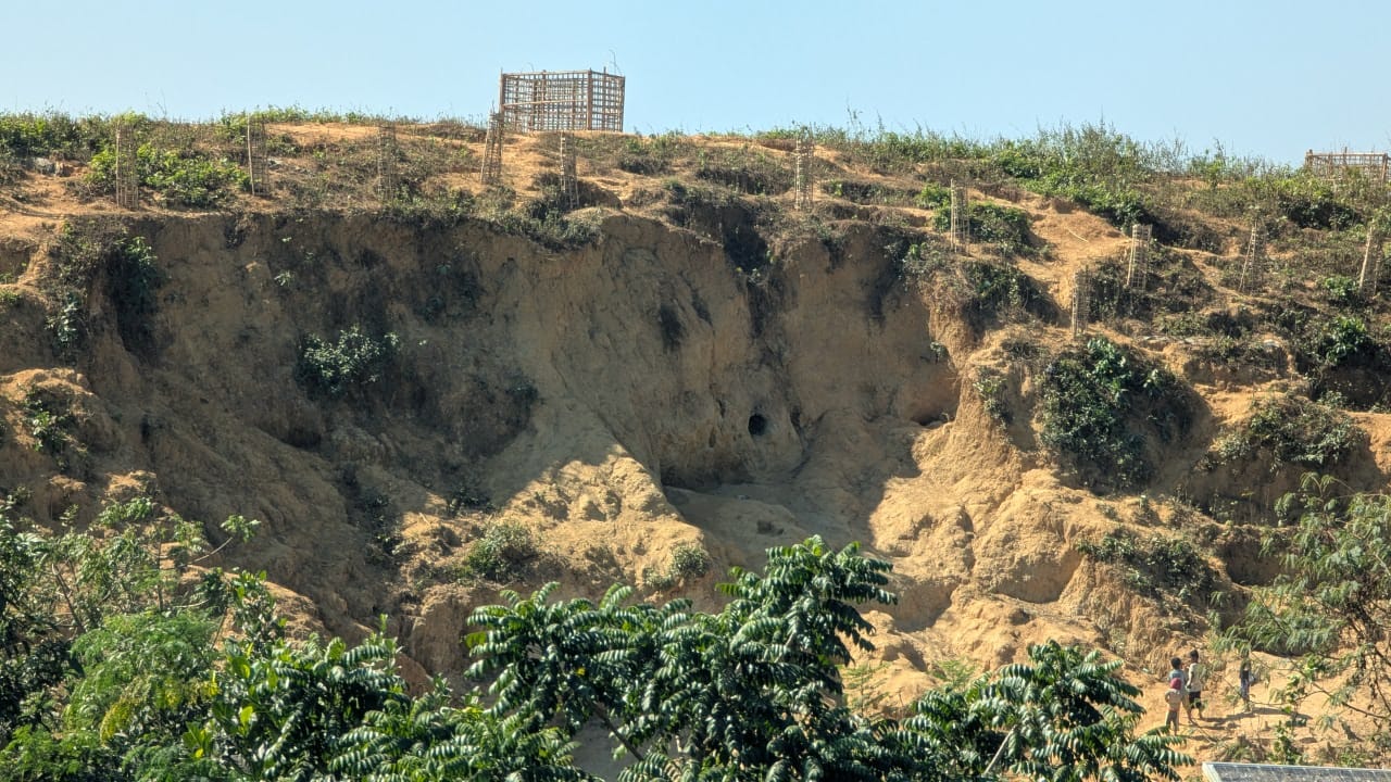
Landslides represent one of the most destructive natural hazards, posing serious threats to human lives, infrastructure, and the environment. These mass movements of soil, rock, or debris down a slope are triggered by various natural and anthropogenic factors, including intense rainfall, earthquakes, slope saturation, deforestation, and unplanned urbanization. In recent decades, the frequency and severity of landslides have increased significantly due to rapid land-use change and climate variability. To mitigate such impacts, accurate landslide susceptibility mapping (LSM) has become a vital component of disaster risk reduction, land-use planning, and sustainable development. Landslide susceptibility refers to the spatial probability of a landslide occurring in each area, based on the combination of conditioning factors that influence slope instability. These factors generally include topographic (slope, aspect, curvature), geological (lithology, faults, soil type), hydrological (rainfall, drainage density), and anthropogenic (road construction, land use) parameters. Traditionally, LSM has relied on heuristic or statistical methods such as frequency ratio, weights of evidence, and logistic regression, which, while useful, often struggle to capture the complex nonlinear interactions among conditioning variables.
In recent years, machine learning (ML) techniques have revolutionized the field of landslide susceptibility assessment. ML models are data-driven and capable of learning intricate relationships between input features and outcomes without requiring explicit assumptions about their distributions. Techniques such as Support Vector Machine (SVM), Random Forest (RF), Artificial Neural Networks (ANN), Naïve Bayes, Gradient Boosting, and Decision Trees have been widely adopted to model landslide occurrence patterns. These models can process large, multidimensional datasets and provide high predictive performance by recognizing hidden correlations among conditioning variables. However, despite their success, traditional machine learning approaches often demand extensive and balanced training datasets, including both landslide (presence) and non-landslide (absence) samples. In many regions, reliable absence data are either unavailable or highly uncertain because it is difficult to verify whether a location has never experienced a landslide or simply lacks documentation. Additionally, complex parameter tuning, computational costs, and potential overfitting problems limit the operational usability of some machine learning methods in landslide studies.
To overcome these limitations, researchers have introduced the Maximum Entropy (MaxEnt) model as a novel machine learning approach for landslide susceptibility analysis. Originally developed for ecological modeling specifically species distribution prediction MaxEnt is a statistical learning algorithm based on the principle of maximum entropy, which states that the best approximation to an unknown probability distribution is the one with the highest entropy, subject to the constraints derived from known information. In simpler terms, MaxEnt estimates the most uniform (least biased) probability distribution possible, given the environmental conditions at observed landslide locations. Unlike many supervised learning models, MaxEnt is a presence-only model, meaning it requires only landslide occurrence data rather than both presence and absence points. This unique feature makes it highly suitable for regions where landslide inventories are incomplete or where non-landslide data are unreliable.
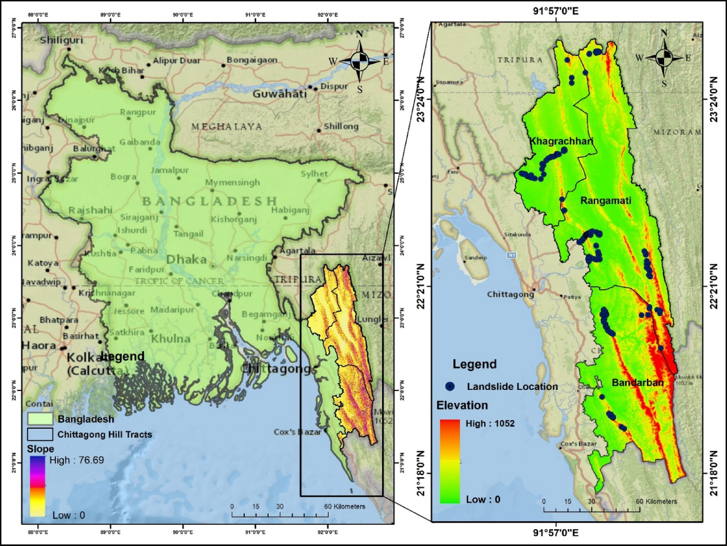
In a MaxEnt-based landslide susceptibility framework, each environmental or conditioning variable is treated as a predictor layer. The algorithm extracts the characteristics of pixels corresponding to known landslide locations and identifies relationships between these variables and landslide presence. By applying the maximum entropy principle, the model generates a probability surface that represents the likelihood of landslide occurrence across the entire study area. The output is a continuous susceptibility map, typically ranging from 0 (least susceptible) to 1 (most susceptible), which can be reclassified into categories such as very low, low, moderate, high, and very high susceptibility zones.
The introduction of MaxEnt into landslide studies offers several distinct advantages over conventional ML and statistical models. Firstly, it performs exceptionally well with limited and presence-only datasets, which are common in developing or data-scarce regions. Secondly, the model employs regularization techniques to avoid overfitting a common issue in data-driven models by penalizing overly complex relationships. Thirdly, MaxEnt provides a clear measure of variable importance, enabling researchers to identify and rank the most influential conditioning factors contributing to slope instability. Additionally, its results are interpretable, reproducible, and compatible with Geographic Information Systems (GIS), which facilitate spatial analysis, visualization, and integration with other hazard and risk layers.
Numerous studies have validated the efficacy of the MaxEnt model in diverse geomorphological and climatic settings. For example, in the Himalayan region, where landslides are frequent due to steep slopes and intense monsoon rainfall, MaxEnt has demonstrated excellent predictive capability with Area Under Curve (AUC) values often exceeding 0.9. Similarly, in Mediterranean and tropical mountainous areas, researchers have reported that MaxEnt performs competitively compared to machine learning models like Random Forest, SVM, and Gradient Boosting, especially when dealing with incomplete inventories. The probabilistic nature of MaxEnt also allows for the integration of remote sensing datasets, such as those derived from satellite imagery (e.g., NDVI, soil moisture, or precipitation intensity), improving spatial accuracy and temporal sensitivity.
Beyond its technical advantages, MaxEnt contributes significantly to practical decision-making in hazard management. The resulting susceptibility maps are invaluable for identifying high-risk zones that require slope stabilization measures, early warning systems, or land-use restrictions. Furthermore, policymakers and disaster managers can use MaxEnt-based maps to allocate resources effectively for landslide prevention and post-disaster recovery efforts.
Despite its numerous strengths, the MaxEnt model is not without limitations. It assumes that the available landslide inventory represents an unbiased sample of the environmental conditions associated with landslides, which may not always hold true. Sampling bias, resolution mismatches among input layers, and spatial autocorrelation can affect the model’s accuracy.
In conclusion, the introduction of the MaxEnt model marks a significant milestone in the evolution of machine learning applications for landslide susceptibility analysis. Its ability to operate effectively with limited data, resist overfitting, and provide interpretable probabilistic outputs has made it one of the most promising models in spatial hazard prediction. By incorporating MaxEnt within a GIS environment, researchers can generate highly detailed susceptibility maps that support evidence-based planning and policy formulation. Therefore, the introduction of MaxEnt as a new machine learning model has not only enhanced predictive modeling capabilities but also deepened our understanding of the intricate relationships between environmental factors and slope processes offering a powerful, data-driven tool for the future of landslide hazard assessment.
Follow the Topic
-
Discover Sustainability
A multi-disciplinary, open access, community-focussed journal publishing results from across all fields relevant to sustainability research whilst supporting policy developments that address all 17 of the United Nations Sustainable Development Goals (SDGs).

Related Collections
With Collections, you can get published faster and increase your visibility.
Food, Societies and Sustainability: Contemporary Concerns around Local Food Production and Consumption
Food goes far beyond nutrition. It reflects sociocultural identities and territorial heritage, consumption dynamics, economic development, public policies, sustainability concerns, food production, distribution and consumption. Understanding food production and food products, practices and strategies offers key insights into both historical traditions and contemporary lifestyles. Around the world, food and drink serve as powerful symbols of identity and attract interest through diverse value chains, economic interests and cultural expressions. On the other hand, traditional and local food systems contribute to cultural heritage, biodiversity conservation and sustainability matters from environmental, sociocultural and economic concerns.
The Collection "Food, societies and sustainability: Contemporary concerns around local food production and consumption" explores how food is locally produced, promoted and protected through public and private initiatives, food-based experiences, media platforms, and sustainable dietary and productive practices. It encourages contributions that examine how food concerns are shaped in contemporary societies, how globalization is affecting local food cultures, emphasizing the role of food as both tangible and intangible cultural heritage. Food preferences, food stereotypes, and attitudes towards food sustainability, analysed through the lenses of generational gaps and gender differences are also welcomed. This Collection seeks original research and case studies using both qualitative and quantitative methods.
Keywords: Food Systems, Food culture, Food Production, Locality, Heritage, Tourism, Gastronomy, Agricultural Biodiversity, Livestock Biodiversity, Food Sustainability, Regenerative Tourism.
This Collection supports and amplifies research related to SDG 2, SDG 3, SDG 4, SDG 5, SDG 10, SDG 12, and SDG 17.
Publishing Model: Open Access
Deadline: Sep 30, 2026
Clean Water and World Sustainability
Water is the lifeblood of our planet, fundamental to all life forms and a cornerstone of human progress. Yet, despite its critical importance, ensuring universal access to clean and safe water remains a pressing global challenge. In the face of complex issues such as climate change, urbanization, and population growth, the need for sustainable water management has never been more urgent. Water security, quality, and accessibility are integral to fulfilling the United Nations' Sustainable Development Goal (SDG) 6, which emphasizes ensuring the availability and sustainable management of water and sanitation for all. However, the path to water sustainability is laden with challenges, ranging from the pollution and contamination of freshwater resources to the degradation of ecosystems that support vital water cycles.
In this context, the proposed research collection, “Clean Water and World Sustainability”, aims to compile pioneering research that addresses the multifaceted issues surrounding clean water, ecosystem health, and global sustainability. This collection seeks to showcase groundbreaking solutions and interdisciplinary approaches that promote sustainable water practices while considering the broader environmental, economic, and social impacts of water use.
We welcome contributions from scholars worldwide that present original research on topics such as: (i) the impact of industrial and agricultural practices on water quality and availability; (ii) advances in water treatment technologies and wastewater management; (iii) the role of freshwater ecosystems in mitigating climate change; (iv) sustainable water governance models and policy frameworks; and (v) the interaction between water scarcity, human health, and socioeconomic development.
This collection provides a unique platform for researchers to disseminate their cutting-edge findings on transformative solutions to the world’s water crisis and contribute to global sustainability efforts. The research presented will not only inform policy decisions but also empower local communities, industry leaders, and environmental advocates to take action in safeguarding and rejuvenating this invaluable resource.
This Collection supports and amplifies research related to: SDG 6 & SDG 11
Keywords: Water Accessibility and Management; Water Security; Water Treatment Technologies; Sustainable Development; Ecosystem Health; Interdisciplinary Approaches; Sewage/Wastewater Reuse
Publishing Model: Open Access
Deadline: Sep 30, 2026


Please sign in or register for FREE
If you are a registered user on Research Communities by Springer Nature, please sign in