Atmospheric rivers and the upper ocean
Published in Earth & Environment and Sustainability
Climate change has become a defining issue of our time. As scientists, we ask questions and conduct research to forward our understanding of what planet Earth will look like under different climatic conditions. In the case of our study, entitled "Response of the upper ocean to northeast Pacific atmospheric rivers under climate change", we use a sophisticated, high fidelity Earth System Model to diagnose the relationship between the upper ocean and a very common weather phenomenon called atmospheric rivers (ARs), peeking into a possible future where the world has continued to burn fossil fuels relatively unchecked.
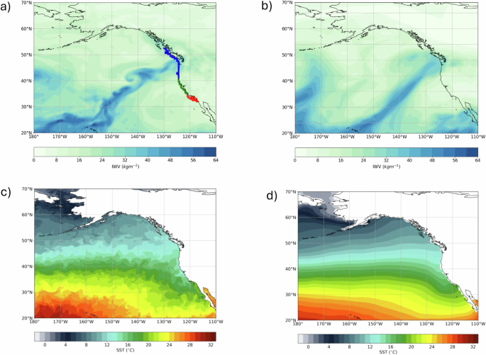
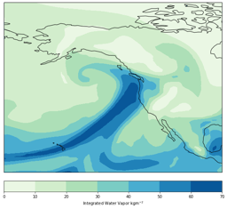
ARs are long, narrow, and meandering “rivers in the sky” that deliver water from lower to higher latitudes and are essential components of Earth's hydrological cycle. Many ARs occur over ocean basins because they tend to co-locate along the climatological storm tracks. However, to date, much of the climate change impacts literature is focused over land and population centers due to the potential for ARs to cause major flooding or relieve drought. Here, we focus on northeast Pacific ARs and their impact on the upper ocean. We divide the North American west coast into three regions: southern California, central California, and the Pacific Northwest, and analyze how ARs under climate change influence important oceanic variables such as sea surface temperature and height, ocean mixed layer depth, and surface energy fluxes at the air-sea interface. Understanding upper ocean impacts requires high fidelity to properly resolve the processes at play. For climate change scenarios, coupling an eddy-resolving ocean model to a 25km grid-spacing high-resolution atmosphere allows us to resolve both ARs and ocean processes regionally and with greater accuracy. In the figure below, we show a snapshot of an atmospheric river, quantified using total column integrated water vapor (IWV), that clearly reflects the ocean eddy structure from the surface below. It nicely illustrates the relationship we are studying.
.png "Snapshot of integrated water vapor from an atmospheric river using an eddy-resolving ocean model")
We find that ARs and their strong winds cause significant upper ocean responses. For coastal communities and city planners, the most pressing discovery is that under climate change, we see a significant increase in sea surface height along coastal locations. ARs push water in the direction of the flow, increasing sea surface heights as ARs approach and make landfall. Changes to sea surface height will be amplified under climate change, and as much as 200% for Pacific Northwest communities. It is important to understand that we are analyzing sea surface height, and not sea level rise. Sea surface height is the height of the ocean surface measured relative to a reference level at a given time and can vary on short timescales due to factors such as the ocean currents and influence from weather, whereas sea level rise is defined as a long-term trend that includes factors like ice-melt and climate interactions. In our study, we maximize the AR fingerprint by quantifying sea surface height as one day after the AR onset date minus three days before. An increase in sea surface height will temporarily elevate the height of the ocean exacerbating flooding over land that occurs during intense precipitation associated with the AR itself. For climate change, this potentially worsens.
ARs imprint on the upper ocean is not limited to sea surface heights, they also leave their mark on the ocean mixed layer depth (essentially the part of the upper ocean that interacts most directly with the atmosphere), as well as the heat in and out of the ocean. ARs tend to produce deeper mixed layers upstream (and shallower downstream). This response will not be amplified but subdued under climate change. This means that mixed layers downstream of the AR may deepen and mixed layers upstream (ahead of the AR passage) will become more shallow. We also find that heat flux responses are regionally dependent, but generally promote cooling upstream and warming downstream of ARs. Under climate change, the mechanism driving the response however is very different for southern California compared to other regions northward. For southern California, the dominant driver for the upstream cooling is evaporation which is strongly reinforced in a warming world. For California and the Pacific Northwest, however, sensible heat is the dominant process driving the climate change response and is actually counter to the historical pattern.
Our results are the culmination of several years of research across a few different institutions leveraged off of a huge community effort that produced extremely high-resolution coupled climate simulations. Allowing the atmosphere and ocean to “talk” to each other in simulations, and quantifying feedbacks therein, is an essential tool for studying climate for the coming years, decades, and centuries. This work represents a first-order exploration of basic ocean responses to ARs and how that may change in a potential future under global warming. It opens the door into a deeper dive into analyzing dominant turbulent ocean circulation and leverages work already done looking at feedbacks between extratropical and tropical cyclones and the upper ocean. ARs, like tropical cyclones, carry enormous amounts of water that, once delivered to land masses and population centers, wreak havoc on local infrastructure. Understanding the nature of how this changes with global warming, will help us to adapt and plan.
Acknowledgements for the funding and facilities that made this research possible: (1) Regional and Global Model Analysis (RGMA) component of the Earth and Environmental System Modeling Program of the U.S. Department of Energy’s Office of Biological & Environmental Research (BER) under Award Number DE-SC0022070, (2)The National Center for Atmospheric Research, which is a major facility sponsored by the National Science Foundation (NSF) under Cooperative Agreement No. 1852977, (3) International Laboratory for High Resolution Earth System Prediction (iHESP) project, a collaboration between the Qingdao National Laboratory for Marine Science and Technology (QNLM), Texas A&M University (TAMU), and the U.S. National Science Foundation National Center for Atmospheric Research (NSF NCAR), (4) NSF Division of Atmospheric and Geospace Sciences (AGS) Climate & Large-Scale Dynamics program under Grant #2231237, (5) Texas Advanced Computing Center (TACC) for providing HPC resources on Frontera (6) NSF NCAR’s Computational and Information Systems Laboratory (CISL) Derecho: HPE Cray EX System.
Follow the Topic
-
Communications Earth & Environment
An open access journal from Nature Portfolio that publishes high-quality research, reviews and commentary in the Earth, environmental and planetary sciences.

Related Collections
With Collections, you can get published faster and increase your visibility.
Hazards in Mountain Regions
Publishing Model: Open Access
Deadline: Nov 02, 2026
Ecosystems under marine heatwaves
Publishing Model: Hybrid
Deadline: Oct 22, 2026
Please sign in or register for FREE
If you are a registered user on Research Communities by Springer Nature, please sign in