Coastal Vulnerability Assessment Using an Integrated Approach
Published in Earth & Environment and Sustainability
Explore the Research
Vulnerability assessment of English and Welsh coastal areas - Scientific Reports
Scientific Reports - Vulnerability assessment of English and Welsh coastal areas
Coastal areas and vulnerability
The term coastal vulnerability has recently gained popularity and significant attention in academic literature. Coastal vulnerability refers to the susceptibility of infrastructure and communities to potential harm from environmental changes and natural disasters. Coastal areas serve as critical interface between land and sea, supporting ecological balance, biodiversity, and economic activities, while also acting as frontline defences against climate change impact. Climate change poses serious threat to regions worldwide, especially low-lying coastal areas. Nearly half of the global population lives near coastlines, and most of the world's largest cities are situated along coasts, underscoring the essential role these areas play in human life and wellbeing.
Why coastal vulnerability assessments
Coastal vulnerability assessments are essential for evaluating global threats and implementing timely actions to mitigate a variety of coastal hazards. Traditionally conducted every 5 years, these assessments are increasingly needed every 3-5 years due to rising climatic change impacts and rapid urbanisation. However, the assessment frequency often depend on specific geographic, physical, and socio-economic conditions. Numerous assessments worldwide have evaluated coastal susceptibility from various perspective, highlighting the importance of integrating physical, climatic, and economic factors to inform adaptable, effective decisions in coastal engineering and management.
What and why CVI (Coastal Vulnerability Index)
The Coastal Vulnerability Index (CVI), first established in 1990 with a quantitative scale from 1 to 5, has become one of the most widely accepted approaches in coastal vulnerability studies. The CVI is critical for assessing vulnerability across multiple dimensions, providing a standardized framework to compare vulnerability across diverse areas. Despite its widespread use at regional, national, and international levels, there remains a gap in its applicability across geographic contexts with varying physical and economic conditions. While progress has been made in assessing coastal vulnerability, most studies have focused primarily on either physical or economic factors. Kantamaneni et al. (2018) introduced the Combined Coastal Vulnerability Index (CCVI), an innovative approach that generates a quantifiable index for comparative evaluations across regions. This approach builds on earlier models successfully applied to different areas, showcasing their robustness. CVI methodologies now have an opportunity to integrate a broader range of parameters, encompassing physical, social, and economic aspects for a more comprehensive assessment.
Our case study areas
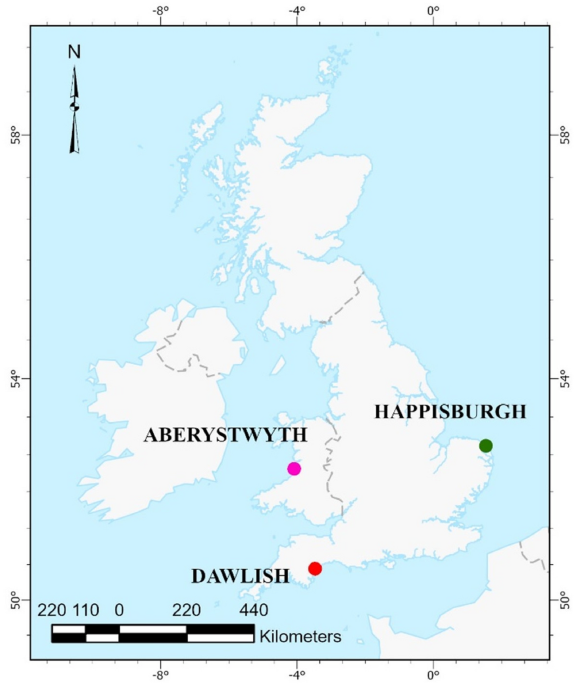
Field visits and existing literature informed the section of case study areas for this assessment. consequently, three areas were chosen: two in England (Dawlish and Happisburgh) and one in Wales (Aberystwyth). The pre-identified areas are particularly vulnerable to climate change and associated hazards, such as coastal flooding, erosion, high waves, storm surges, and sea level rise, despite the presence of coastal defence structures. Dawlish, a seaside resort town in Teignbridge on the south coast of Devon, England, exemplifies the acute vulnerability of coastal communities to climate change and extreme weather events. Happisburgh, a village and civil parish located in Norfolk, England, highlights the dynamic challenges coastal areas face due to erosion and effects of human intervention on natural coastal processes. Aberystwyth, a coastal town in Ceredigion, Wales, is noted not only for its natural beauty and historical landmarks but also for its significant susceptibility to coastal erosion.
How we did the assessment
In this study, we adapted the Physical Coastal Vulnerability Index (PCVI), Economic Coastal Vulnerability Index (ECVI), and Combined Coastal Vulnerability Index (CCVI) from Kantamaneni et al.’s methodology to assess the selected case study sites: Happisburgh, Aberystwyth, and Dawlish. Physical parameters include Beach Width, Dune Width, Coastal Slope, Distance of Vegetation behind the Back Beach, Distance of Built Structures behind the Back Beach, and Sea Defences, each with respective ratings. Economic parameters cover Commercial Properties, Residential Properties, Economic Value of the site, and Population, with corresponding ratings. Economic data is aggregated within each 1km-by-1km cell or 0.5-by-0.5km cell to emphasize the area’s economic and physical demographic characteristics. Finally, a mathematical CVI formula was applied to assess overall coastal vulnerability.
What we have found
Based on the cumulative PCVI scores, nearly 78% of cells are classified as highly vulnerable, and over 20% fall into the moderate vulnerability category. This study concludes that all three regions are highly vulnerable, with the highest vulnerability score in Aberystwyth, followed by Happisburgh. PCVI trends indicate a consistently high level of vulnerability across the assessed cells.
The ECVI scores, however, present different findings compared to the PCVI results. aggregated ECVI scores reveal that approximately 33% of cells are classified as high to very highly vulnerable, while nearly 40% are in the moderate vulnerability category, with Dawlish showing the highest ECVI score. ECVI trends suggest a vulnerability range from moderate to very high levels.
For CCVI, Aberystwyth has the highest CCVI score, suggesting it may face the greatest overall vulnerability (Fig.1). Happisburgh, though it has the highest PCVI, indicating significant physical exposure, has the lowest ECVI, suggesting less economic risk. Its CCVI score points to a similar overall vulnerability level, reflecting the balance of physical and economic risk factors.
.png "Fig.1 Combined Coastal vulnerability for Dawlish, Aberystwyth, and Happisburgh")
Fig.1 Combined Coastal vulnerability for Dawlish, Aberystwyth, and Happisburgh
How these results help
The methodology adopted in this study to assess coastal vulnerability is multi-dimensional and can be applied to any suitable area without geographical limitations. The findings of this research support regional and national policymakers in enhancing or establishing strategies to address vulnerabilities in coastal areas in coastal areas across England and Wales. Coastal managers can leverage the results to develop risk management and adaptation measures. These measures, whether through soft or hard engineering solutions, can strengthen coastal communities and infrastructure against potential coastal disasters.
Follow the Topic
-
Scientific Reports
An open access journal publishing original research from across all areas of the natural sciences, psychology, medicine and engineering.

Related Collections
With Collections, you can get published faster and increase your visibility.
Infectious disease diagnostics
Publishing Model: Open Access
Deadline: Sep 23, 2026
AI in Education
Publishing Model: Open Access
Deadline: Oct 09, 2026

Please sign in or register for FREE
If you are a registered user on Research Communities by Springer Nature, please sign in