Cost-effective drone toolkits for stream habitat monitoring — enabling scalable, high-resolution assessments
Published in Earth & Environment, Computational Sciences, and Civil Engineering
Monitoring stream habitat health is essential for understanding restoration outcomes, ecological resilience, and watershed management. Yet, conventional monitoring approaches — including transect-based surveys and manual habitat scoring — often demand significant time, labor, and cost. These limitations are especially challenging when managers need repeated assessments, rapid reporting after storm events, or broad spatial coverage beyond a single reach.
Our newly published paper in Environmental Monitoring and Assessment presents a cost-effective, UAV-based toolkit that offers a practical alternative for achieving high-resolution and repeatable stream habitat evaluations.
The workflow integrates:
-
Automated flight planning using off-the-shelf drones
-
Structure-from-Motion photogrammetry to generate elevation, vegetation, and channel structure products
-
Multi-Metric Index (MMI) evaluation, deriving habitat indicators
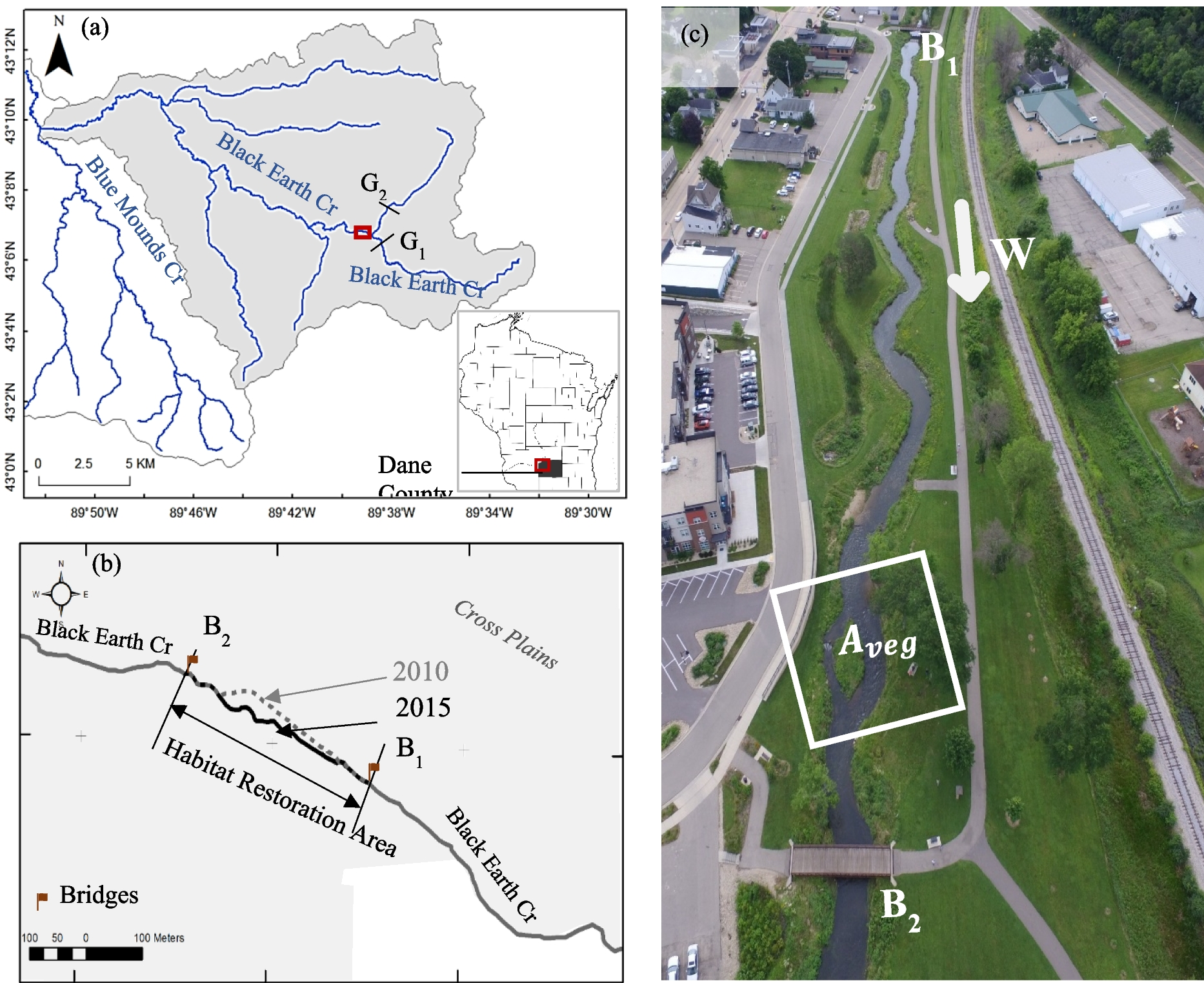
Results from Black Earth Creek (Wisconsin, USA) demonstrated strong agreement between UAV-derived metrics and traditional field assessments. More importantly, the spatial continuity offered by aerial imagery revealed localized degradation patterns and riparian corridor changes that field sampling alone could not detect.
This approach has immediate relevance for:
-
Stream restoration monitoring
-
Fisheries habitat assessment
-
Watershed planning and project prioritization
-
Environmental reporting and compliance
-
Post-event reconnaissance (e.g., storms, flooding, erosion)
Our goal is to support agencies, researchers, and community stakeholders by providing accessible, scalable monitoring options that fit within real-world resource constraints.
📄 Read the full article: https://doi.org/10.1007/s10661-025-14814-9
💬 We welcome discussion on adapting this approach to different ecological or geographic contexts and invite collaboration for further development.
Follow the Topic
-
Environmental Monitoring and Assessment
This is a journal that explores the design and implementation of monitoring systems and pollution risk assessment methods.

Related Collections
With Collections, you can get published faster and increase your visibility.
Advancing Risk Assessment and Resilience Strategies for Climate Extremes and Multi-Hazard Events
Water is a fundamental driver of socio-economic development and deeply interconnected with nearly every Sustainable Development Goal (SDG). However, water resources face unprecedented pressures from population growth, urbanization, and climate change. Currently, 36% of the global population resides in water-scarce regions, with projections indicating that nearly four billion people may face severe water shortages by 2050. Climate change exacerbates these challenges by increasing the frequency and severity of droughts, floods, and extreme weather events worldwide. The complexity intensifies in transboundary contexts, where approximately 60% of global freshwater flows are shared between two or more countries. Transboundary water cooperation is essential for regional stability, sustainable development, and conflict prevention. Current progress indicates that at the present pace, only a third of countries sharing transboundary waters will achieve adequate cooperation frameworks by 2030. Without strengthened mechanisms, competing water demands can lead to resource depletion, ecological degradation, and diplomatic tensions.
The 4th Roorkee Water Conclave (RWC 2026) jointly organized by Indian Institute of Technology Roorkee (India) and National Institute of Hydrology Roorkee (India), addresses these challenges under the theme "Transboundary Water Cooperation Through Nexus Approach".
This Collection is dedicated to exploring innovative strategies in transboundary water management that are pivotal in tackling the intricate challenges of water scarcity, climate change, and enhancing water security through nexus approaches. It prioritizes environmental monitoring and assessment, observations, indicators, and analytics that quantify hazard processes, exposure, and impacts on water resources, ecosystems, and environmental quality in highly vulnerable settings such as the Himalayas and densely populated river basins of South Asia. The scope targets method-driven papers that improve how we detect, model, and evaluate floods, droughts, heatwaves, glacier-melt–driven hydrologic change, and compound/cascading events (e.g., flood–drought whiplash). While the 4th Roorkee Water Conclave (RWC 2026) emphasizes transboundary cooperation and nexus thinking, submissions should frame these dimensions through the lens of monitoring systems, interoperable data-sharing, and evidence-based assessment that supports preparedness and resilience planning. While the Special Issue is anchored in contributions from RWC 2026, it is not restricted to conference papers. Submissions are invited from the broader scientific community, provided they align with the scope and thematic focus of the issue.
The key topics in the special issue broadly include:
i. Transboundary Water Governance and Institutional Frameworks: This thrust area will focus on the latest advancements in governance mechanisms, joint river basin organizations, benefit-sharing arrangements, policy instruments, and stakeholder engagement frameworks that facilitate effective cooperation across shared water basins.
ii. Integrated monitoring of climate extremes and cryosphere hazards for water security: Multi-source observation frameworks combining satellite remote sensing (e.g., SWOT), reanalysis and gauge networks (e.g., ERA5), cryosphere indicators (snow, glacier, glacial lakes), and in-situ/low-cost IoT sensing to detect extremes (floods, droughts, avalanches, GLOFs) and pinpoint monitoring gaps in data-scarce and high-mountain regions.
iii. Resilience strategies, early warning, and cross-boundary data integration for actionable decisions: Impact-based forecasting and early warning systems, nature-based solutions, and climate-resilient infrastructure/operations, supported by interoperable datasets, uncertainty-aware ensemble assessment, reproducible workflows, and transboundary data-sharing/governance mechanisms that translate monitoring evidence into practical resilience outcomes.
iv. Ecohydrology, environmental flows, and water-quality resilience under multi-hazard extremes: Integrated monitoring and assessment of how floods, droughts, and storm events alter flow regimes, pollutant mobilization/concentration, and river–watershed ecological function—linking environmental flow diagnostics, ecosystem-service impacts, source tracking (including emerging pollutants), and performance of treatment/reuse options to support biodiversity protection, public-health safety, and circular-economy–oriented water security.
Publishing Model: Hybrid
Deadline: Jan 31, 2027

Please sign in or register for FREE
If you are a registered user on Research Communities by Springer Nature, please sign in