Digging Deeper into the First US Groundwater Well Database
Published in Earth & Environment and Research Data
Explore the Research

A database of groundwater wells in the United States - Scientific Data
Scientific Data - A database of groundwater wells in the United States
The management and use of natural resources is critical to sustaining both our environment and economies. One resource, groundwater, is particularly important when discussing water security, food production, environmental health, and resilience against climate change. Much of the world’s groundwater resources had been untapped until the last century, when technological advances made it possible to unlock these waters for our homes, farms, schools, and businesses. In the United States, groundwater wells are scattered across the landscape and act as straws to gulp up the vast pools of water hidden beneath our feet. Over 48.5 of the nation’s homes, businesses, and other community water uses come from groundwater1, which is supplied to them via a well. Despite the importance of groundwater wells, we do not know how many wells exist in the US, where they are, when they were built, and what purposes they serve—until now.
In our , we introduce the United States Groundwater Well Database (USGWD)2, the first of its kind comprehensive inventory of US groundwater wells. This database provides a novel resource to support decision-making and policy formation, improve our understanding of how groundwater is used, and identify opportunities for better management of this critical natural resource.
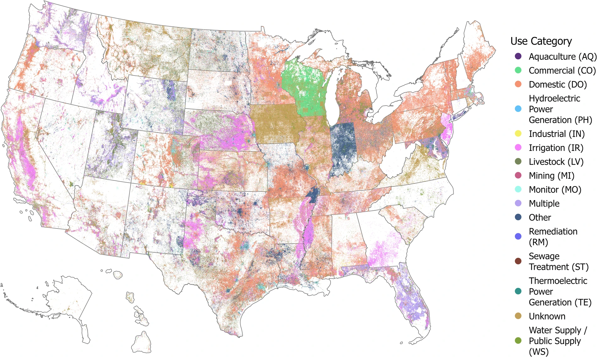
The USGWD comprises over 14.2 million well records, surpassing the number of wells identified in all. Figure 1 displays the spatial distribution of over 12.3 million well records with consistent and complete locational data. While most wells in USGWD were constructed in the last half century, some well records date back as far as 1763. Our database provides details about each well, such as the well purpose, location, depth, capacity, status of each well, construction year, and more.

Well records within USGWD were collected from state governments and other sources that maintain well databases. The quality and completeness vary significantly between states. We have standardized disparate well records within USGWD, and we highlight potential data quality issues within the reported well records, including locational inaccuracies and duplication flags. We have also supplemented state-reported well records with additional details, such as the underlying aquifer, subwatershed, and detailed irrigation subcategories (e.g., crop irrigation and/or golf course irrigation). For instance, by pairing state-reported well records with the United States Aquifer Database3, we can visualize the number and density of wells overlaying each major aquifer (Figure 2). We can identify hotspots of well drillings, indicating highly productive groundwater sources but also potential sustainability issues.

Creating this unique database took multiple years and presented many challenges. Each state had its own collection methods, definitions, and levels of completeness. Our team spent more than two and a half years contacting each of the 50 states, seeking their cooperation to gather the most up-to-date data and their consent to publish our standardized data. In instances where states did not publicly share their groundwater well data, we resorted to filing requests under the Open Records Act or the Freedom of Information Act (FOIA) to obtain the necessary records. Then, we faced data pre-processing and cleaning challenges due to varying data qualities across states. Some data were well maintained with comprehensive metadata, while others had incomplete metadata and inconsistent formats and units. In such cases, we manually processed and cleaned the data with help from the states. This pre-processing could take from a few days to months, as response speeds and frequencies varied, and sometimes multiple contacts were needed before reaching someone who could assist us. Finally, we standardized the data into the cohesive USGWD, with multiple rounds of quality assurance and quality control (QA/QC) to ensure its integrity.
We made USGWD publicly available due to our commitment to open science. In doing so, we hope that this novel data product will spur the research community towards numerous innovative studies that help us better understand how and where groundwater is used and the impacts of those uses. We believe that open data leads to improved understanding, improved understanding to informed decision-making, and informed decision-making to better outcomes for society and the environment. This dataset represents a foundational step towards fostering future research, applications, and policies for a sustainable future. We are excited to see what you do with USGWD!
Hosted on HydroShare (https://doi.org/10.4211/hs.8b02895f02c14dd1a749bcc5584a5c55)1, USGWD is available in both tabular and vector formats, accompanied by comprehensive metadata and codes used for standardization.
References:
- Dieter, C. A. et al. Estimated Use of Water in the United States in 2015. Circular https://pubs.usgs.gov/publication/cir1441 10.3133/cir1441 (2018).
- Lin, CY., Miller, A., Waqar, M. et al. A database of groundwater wells in the United States. Sci Data 11, 335. https://doi.org/10.1038/s41597-024-03186-3 (2024).
- Lin, C., Miller, A., Waqar, M. & Marston, L. A Database of Groundwater Wells in the United States. HydroShare https://doi.org/10.4211/hs.8b02895f02c14dd1a749bcc5584a5c55 (2024).
- GebreEgziabher, M., Jasechko, S. & Perrone, D. United States Aquifer Database. HydroShare. http://www.hydroshare.org/resource/d2260651b51044d0b5cb2d293d21af08 (2022).
Follow the Topic
-
Scientific Data

A peer-reviewed, open-access journal for descriptions of datasets, and research that advances the sharing and reuse of scientific data.
Related Collections
With Collections, you can get published faster and increase your visibility.
Data for crop management
Publishing Model: Open Access
Deadline: Apr 17, 2026
Data to support drug discovery
Publishing Model: Open Access
Deadline: Apr 22, 2026


Please sign in or register for FREE
If you are a registered user on Research Communities by Springer Nature, please sign in