Embracing Open Science: Designing a Systems Approach for Complex Urban Systems
Published in Social Sciences

Our rapidly changing world faces various global challenges, including Covid-19, climate change, and food and water security. Cities, being hubs of innovation and resources, offer the best opportunity for concerted efforts to find breakthrough solutions. However, managing and planning cities is a daunting task due to their vast scale and complexity.
Urban planners require improved tools to comprehend and contextualize large urban systems, as well as to process the vast amount of emerging big data from cities. Crowdsourced open data and the proliferation of open source tools have emerged as significant game changers for urban innovation, empowering planners with actionable insights (Yap et al., 2022). Recognizing the need for promoting impactful research, several American federal agencies have declared 2023 as the year of open science (Gentemann, 2023). This move further strengthens the drive towards using data-driven approaches in addressing urban challenges.
Urban street networks are the lifeblood of cities, crucial for connecting various urban components and enhancing our understanding of urban environments. Although we have made significant progress in comprehending the structure and layout of city networks, there is still much to learn about their significance and context. Fortunately, the increasing availability of open data presents opportunities to enrich urban networks with specific location information, unlocking a wide range of potential use cases.
In line with this, we are proud to introduce Urbanity, an open source Python tool designed to offer planners a seamless and efficient means of generating spatial representations of urban networks and their contextual features across different geographical scales and locations. Developed entirely on open source software and data, Urbanity draws from a variety of heterogeneous urban domains, including street view imagery, building morphology, population subgroups, urban points of interest, and road network indicators. Our paper provides detailed insights into how we carefully select, download, process, and clean the diverse open data layers.
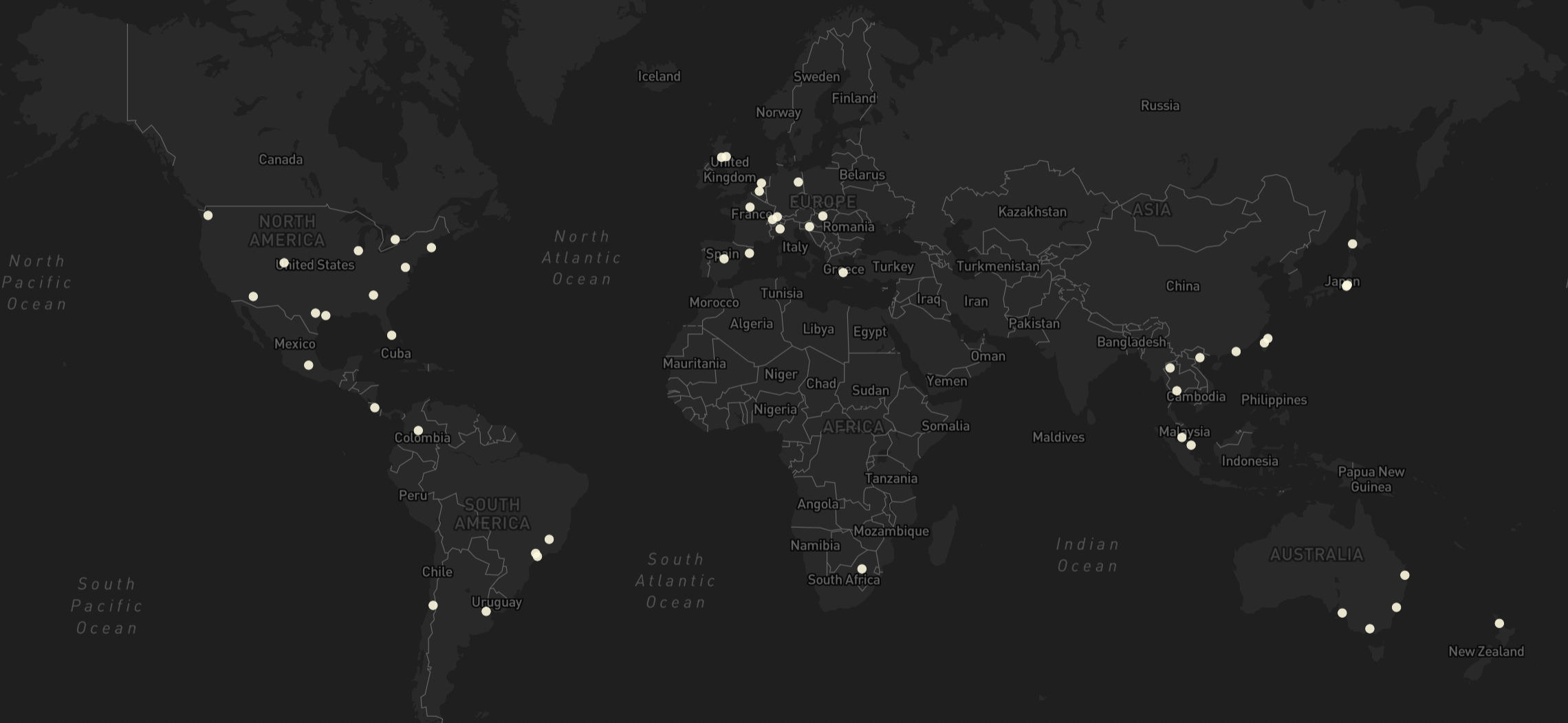
Up to this point, Urbanity has been successfully applied to 50 global cities, spanning diverse geographical regions.
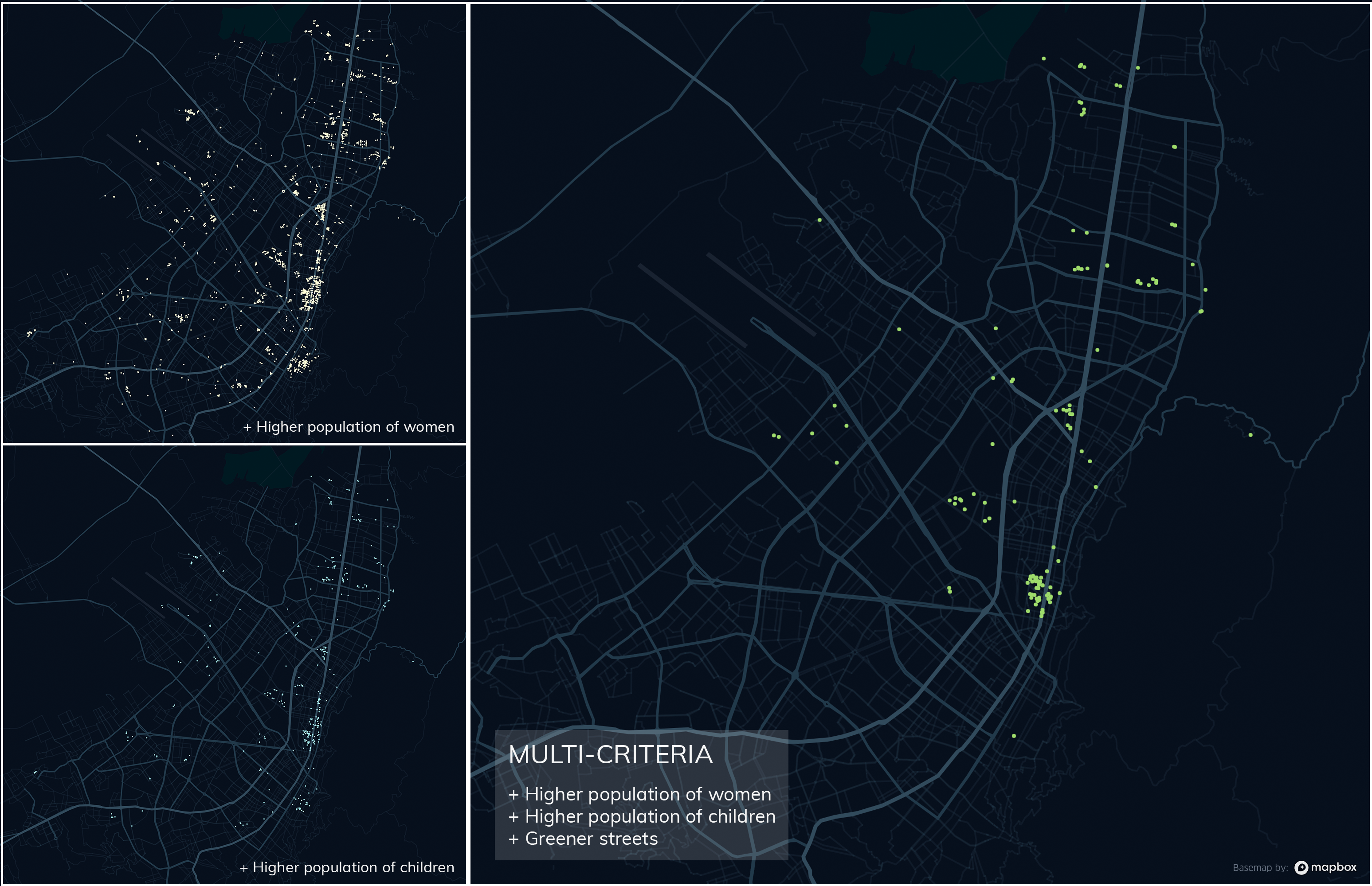
Urbanity offers a versatile range of urban analytical use cases, and one area of application is leveraging its rich contextual information for multi-criteria site selection and assessment. An example of this is an application to Bogotá's innovative `Block of Care' framework. The framework is designed to provide support and development opportunities for systematically marginalised women caregivers at the neighbourhood level.
By utilizing Urbanity, planners can identify optimal locations for these care blocks, focusing on areas with a high proportion of women and children across various neighborhoods. Additionally, data on streetscapes, such as greenery and visual information, can be integrated to assess the walking environments surrounding these care blocks. The map provided demonstrates how Urbanity facilitates an iterative process of identifying urban areas with a high density of women and children, as well as streets with ample greenery. This comprehensive approach enhances the decision-making process and empowers planners to make well-informed choices for the `Block of Care' implementation.
Urbanity's capabilities extend to aggregating urban information for arbitrary subzone configurations, even beyond traditional census tract boundaries. This functionality proves valuable in uncovering the hidden spatial structure of cities and gaining a deeper understanding of their characteristics. For instance, we examine building footprint complexity and road intersection density across five diverse global cities: Singapore, Bangkok, Paris, Chicago, and Seattle. These indicators provide insights into the development history of these cities. By using Urbanity to analyse building footprint complexity, we can identify variations in architectural intricacy and understand how urban areas have evolved over time (Barthelemy et al., 2013). Similarly, examining road intersection density allows us to discern the level of urban planning and transportation networks' sophistication. Through this analysis, Urbanity enables us to compare and contrast these five cities, unveiling unique patterns that contribute to our knowledge of urban development across different regions. This information can be invaluable for urban planners, researchers, and policymakers seeking to make informed decisions for the sustainable growth and improvement of cities.
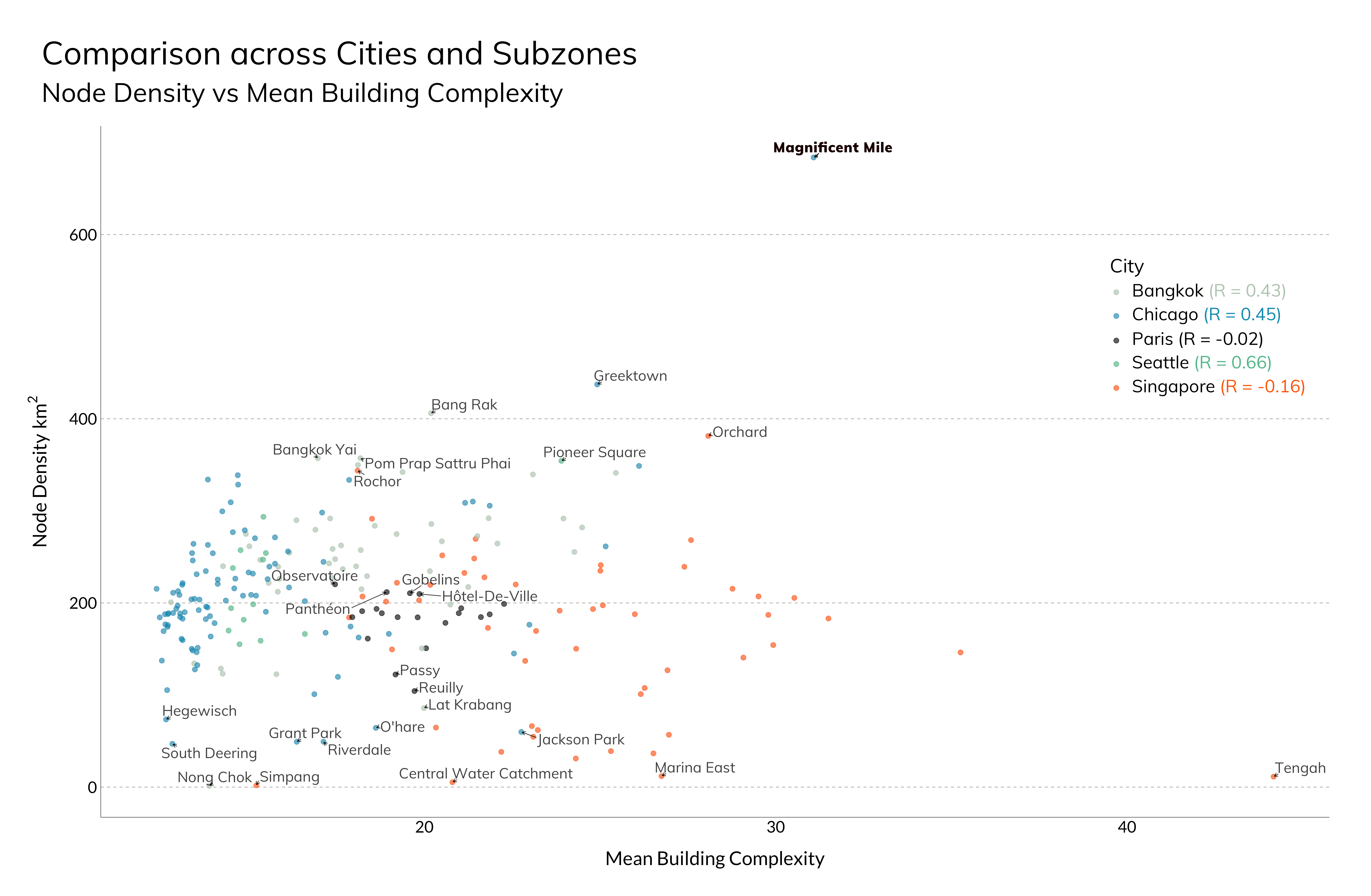
Cities exhibit notable and distinct patterns that correspond to their historical context. For instance, Paris, with its long history of centralized planning, showcases high homogeneity across its subzones. In contrast, cities like Singapore, being a nation-state with diverse land use requirements, display the largest heterogeneity among the group. Furthermore, American subzones can be identified by their low average mean building complexity, which aligns with the well-known urban block morphology. However, certain exceptions, such as the Magnificent Mile district in Chicago—a premier arts and commercial area—stand out from the typical pattern.
To address the joint challenges of urbanization and sustainability effectively, the use of holistic tools becomes crucial in fostering an interdisciplinary and grounded understanding of urban space. These tools support a diverse range of urban applications and use cases. Given the complexity of urban challenges, an interdisciplinary approach is fundamental in designing systemic solutions for cities. In this pursuit, open science will play a central role, driving urban innovation and supporting evidence-based urban planning. By promoting transparency and collaboration, open science will contribute significantly to finding sustainable solutions for our cities' ever-evolving needs.
References
practice. Comput. Environment Urban Syst. 96, 101825 (2022). https://doi.org/10.1016/j.compenvurbsys.2022.101825
Gentemann, C. Why NASA and federal agencies are declaring this the Year of Open Science. Nature 613, 217 (2023).
Barthelemy, M., Bordin, P., Berestycki, H. & Gribaudi, M. Self-organization versus top-down planning in the evolution of a city. Sci. Rep. 3, 1–8 (2013).
Follow the Topic
-
npj Urban Sustainability

An open access, online-only journal for urban scientists, policy makers and practitioners interested in understanding and managing urbanization processes.
Related Collections
With Collections, you can get published faster and increase your visibility.
Reimagining Urban-Rural Relationships for Sustainable Futures
Publishing Model: Open Access
Deadline: Aug 10, 2026
Radical Civic Practices: The Future of Urban Environmental Justice Studies in a Highly Unequal World
Publishing Model: Open Access
Deadline: Mar 10, 2026

Please sign in or register for FREE
If you are a registered user on Research Communities by Springer Nature, please sign in