Exploring ClimateAF: High-Resolution Historical and Future Climate Data for Africa
Published in Earth & Environment and Mathematics
Why we built ClimateAF
Africa’s diverse landscapes—from tropical forests to desert margins and highland plateaus—support equally diverse ecosystems, agricultural zones, and livelihoods. Yet, reliable high-resolution climate data to guide planning, adaptation, and conservation efforts remain difficult to access and often inconsistent across national boundaries.
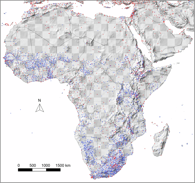
ClimateAF was created to bridge this gap. The platform offers free, high-resolution climate data for the African continent, including a wide range of bioclimatic variables (Fig. 1). It includes both interpolated historical data and future projections under various greenhouse gas emission scenarios, covering the years 1901 to 2100.
Designed for accessibility, ClimateAF supports point-and-click extraction for individual locations, spreadsheet-based batch queries, and the generation of gridded climate datasets at custom resolutions.

What’s under the hood?
ClimateAF uses advanced machine learning—specifically, deep neural networks—to map complex climate patterns, especially in mountainous areas where traditional interpolation methods fall short.
We trained feed-forward neural networks on 18 spatial predictors, including topographic features (e.g., slope, aspect) and atmospheric variables (e.g., wind strength and direction), to generate monthly temperature and precipitation estimates. These models learn spatial relationships between weather station data and terrain-based predictors to produce highly accurate surfaces.
. Subsequently, orographic precipitation, rain shadows, lake and coastal effects are modeled by a deep neural network (Step 2). Lastly, lapse-rate based downscaling is applied to generate high-resolution grids of monthly, seasonal, and bioclimatic variables.")
Figure 2. Visual summary of the novel 3-step methodological approach to climate interpolation. Thin-plate splines allow for a first approximation of monthly climate variables (Step 1). Subsequently, orographic precipitation, rain shadows, lake and coastal effects are modeled by a deep neural network (Step 2). Lastly, lapse-rate based downscaling is applied to generate high-resolution grids of monthly, seasonal, and bioclimatic variables.
Statistical validation and visual assessments showed that the approach can reliably model known weather patterns, such as orographic lift and rain shadows (see Fig. 3 below). This makes ClimateAF not just a new dataset, but a methodological advance in climate data science.

Figure 3. January precipitation maps: comparison of neural network–enhanced interpolations with satellite-based land cover imagery, showing that high precipitation coincides with forest cover.
Applications and use cases
Our Climate software packages for North America, Europe, and Asia Pacific have already been widely adopted by researchers and practitioners working in:
- Forest restoration and reforestation, where site-level climate data guide species selection;
- Agricultural planning, where historic climate normals and future scenarios inform crop suitability and risk assessments;
- Biodiversity and species distribution modeling, especially for endemic or threatened species;
- National adaptation strategies and climate resilience planning.
To support broad adoption, ClimateAF includes a user-friendly interface for extracting data specific locations and downloading complete climate grids. A short introduction video for the database and software is available here (6 min):
Caveats and limitations
ClimateAF achieves high spatial accuracy, especially in mountainous regions where temperature patterns, in particular, are resolved through lapse-rate adjustments, producing detail at the sub-kilometer scale. In contrast, features like rain shadows and orographic precipitation are inherently broader in scale and are modeled at a coarser resolution of approximately four kilometers.
It is also important to note that the dataset is ultimately based on standard weather station data (air temperature 2 m above ground in shaded conditions). This means that local microclimates—such as those shaped by vegetation, urban heat islands, or topographic hollows—are not represented.
Also, while ClimateAF provides historical data as monthly averages, it can be combined with daily datasets like ERA5 using a change-factor approach for finer temporal applications.
Looking ahead
ClimateAF is part of a broader initiative to democratize access to high-resolution climate information globally, especially for underrepresented regions. Future updates will include new GCMs from CMIP7 as they become available. Similarly, we update the software with historical data options from CRU-TS and ERA5 as they become available.
We hope that ClimateAF will serve as both a research tool and a practical resource for climate-resilient development across Africa. We encourage users to explore the dataset, cite the associated publication, and share feedback or case studies using the tool.
Explore the tool and download data at: https://tinyurl.com/ClimateAF
Read the full Scientific Data publication: https://www.nature.com/articles/s41597-025-05575-8
Follow the Topic
-
Scientific Data
A peer-reviewed, open-access journal for descriptions of datasets, and research that advances the sharing and reuse of scientific data.

Related Collections
With Collections, you can get published faster and increase your visibility.
Genomics in freshwater and marine science
Publishing Model: Open Access
Deadline: Jul 23, 2026
Computer vision in plant science and agriculture
Publishing Model: Open Access
Deadline: Jul 10, 2026
Please sign in or register for FREE
If you are a registered user on Research Communities by Springer Nature, please sign in