From microscale to mesoscale: bridging laboratory and engineering geological evaluations of non linear soil behaviour
Published in Earth & Environment
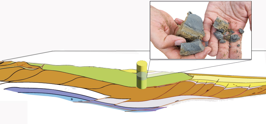
The shaping of the non - linear soil behaviour
The surface of the Earth is made up of a variety of soil types. The understanding of their mechanical behaviour due to seismic loads definitely matters since it can modify frequency and amplitude of waves when they reach a site.
Many past earthquakes (such as the one of the Mexico City in 1985) highlighted the occurrence of phenomena, which are consequences of the so called ‘soil non-linearity’. At a distance of about 400 m from the source, severe damages and human losses were caused from the collapses of buildings in a limited area of Mexico City, where clay deposits with a very high water content at the liquid limit were present.
Why not make an effort incorporating this knowledge? Earthquakes cannot be predicted, but seismic site effects may be forecasted in peacetime and seismic risk prevention plans may be improved before an earthquake arrives.
Simulations of waves propagation are a recurrent practice for the quantification of the ground motion expected at a site. To carry out them, scientific community collects laboratory tests results sampled in different type of soils to provide detailed evaluations.
In particular, in Italy establishing a harmonization strategy for the entire set of geotechnical data harvested during Seismic Microzonation studies was an unanswered question, which we exploited in our article: “Shear modulus reduction and damping ratios curves joined with engineering geological units in Italy” (https://doi.org/10.1038/s41597-023-02412-8), published on Scientific Data, 10, 625 (2023).
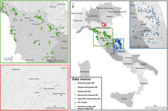
We were challenged to make re-usable information for future seismic microzonation studies. In particular, we collected 485 G/G0 (γ) and damping ratio D(γ) curves from multiple literature sources and available in Italy. Each curve was associated with the related engineering geological units considered in seismic microzonation studies. This aspect represents one of the main findings we were exploring. The data are publicly available at the doi: https://zenodo.org/record/8134979.
Dataset is conceived in a data structure useful for searching information following different desiderata of the users: averaged customed curves are presented in a single file for each unit, while raw curves are archived in separated folders. Each case history includes identifying information (e.g. ID, geographic coordinates) in a metadata file attached to the dataset.
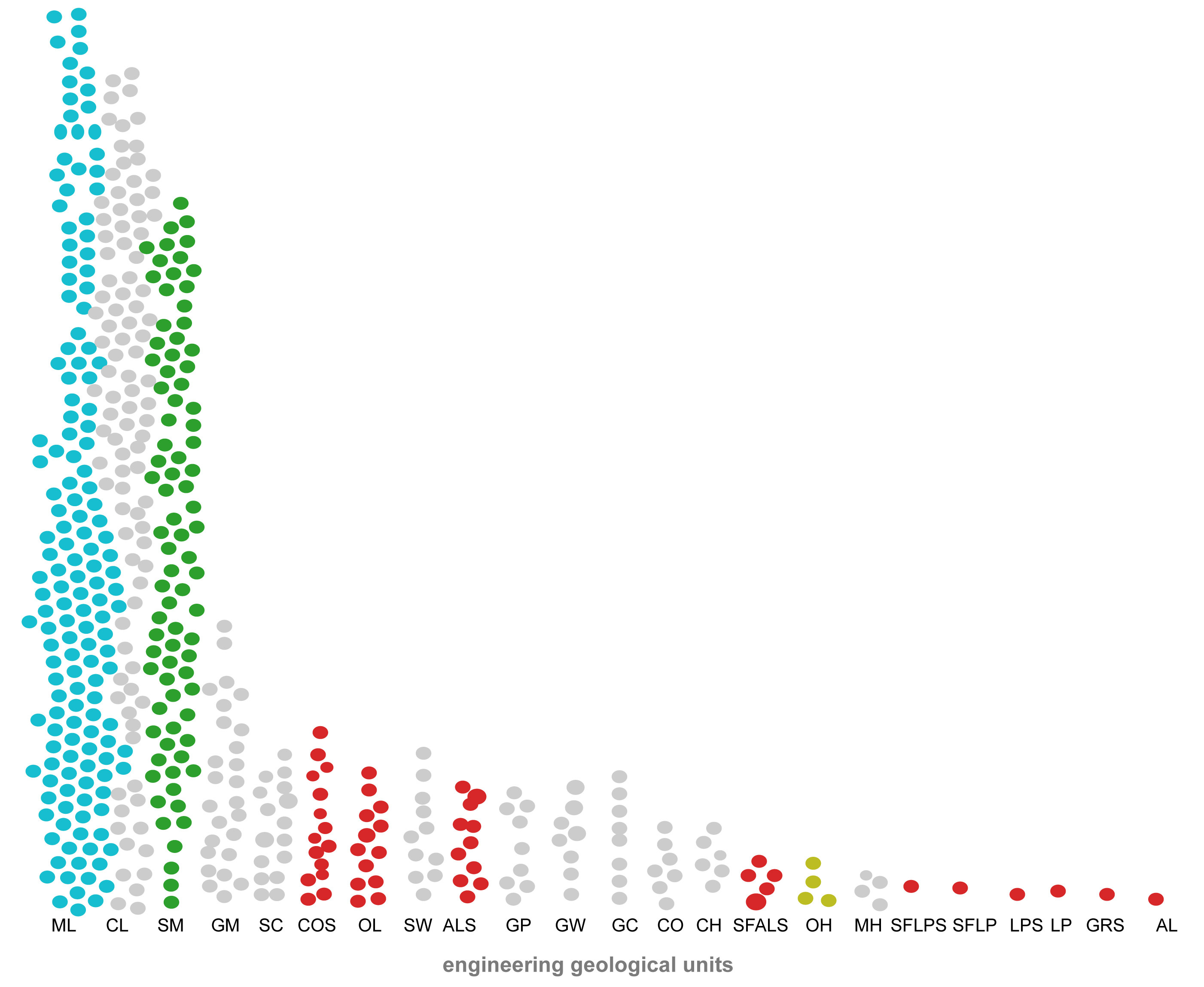
The following figure, based on all the data, so from the fine-grained soils to the coarse and lithoid and consolidated deposits of geological formations, shows the distribution of the engineering geology codes among the dataset. The ML (Inorganic silts, fine silty-clayey sands, low plasticity clayey, silts), the CL (Middle-low plasticity inorganic clays, gravel-sandy clays, silty clays) and the SM (Silty sands, mixed sands and silts) engineering geological units dominate the scene since they constitute together the 70 % of the dataset. Figure also graphically visualises the similarities among available samples: samples were taken mostly in unconsolidated clastic deposits of cover terrain units (grey, blue, green and yellow circles), although about 10% of the tests were carried out for geological bedrock units (red circles).
The goal of this following graph is to visualize the depth of the sample (top depth) in our dataset, varying the soils. The shown contour plot describes that samples were taken mostly at depths ranging from 1 m to 40 m below ground level with a maximum depth of 70 m a.s.l.
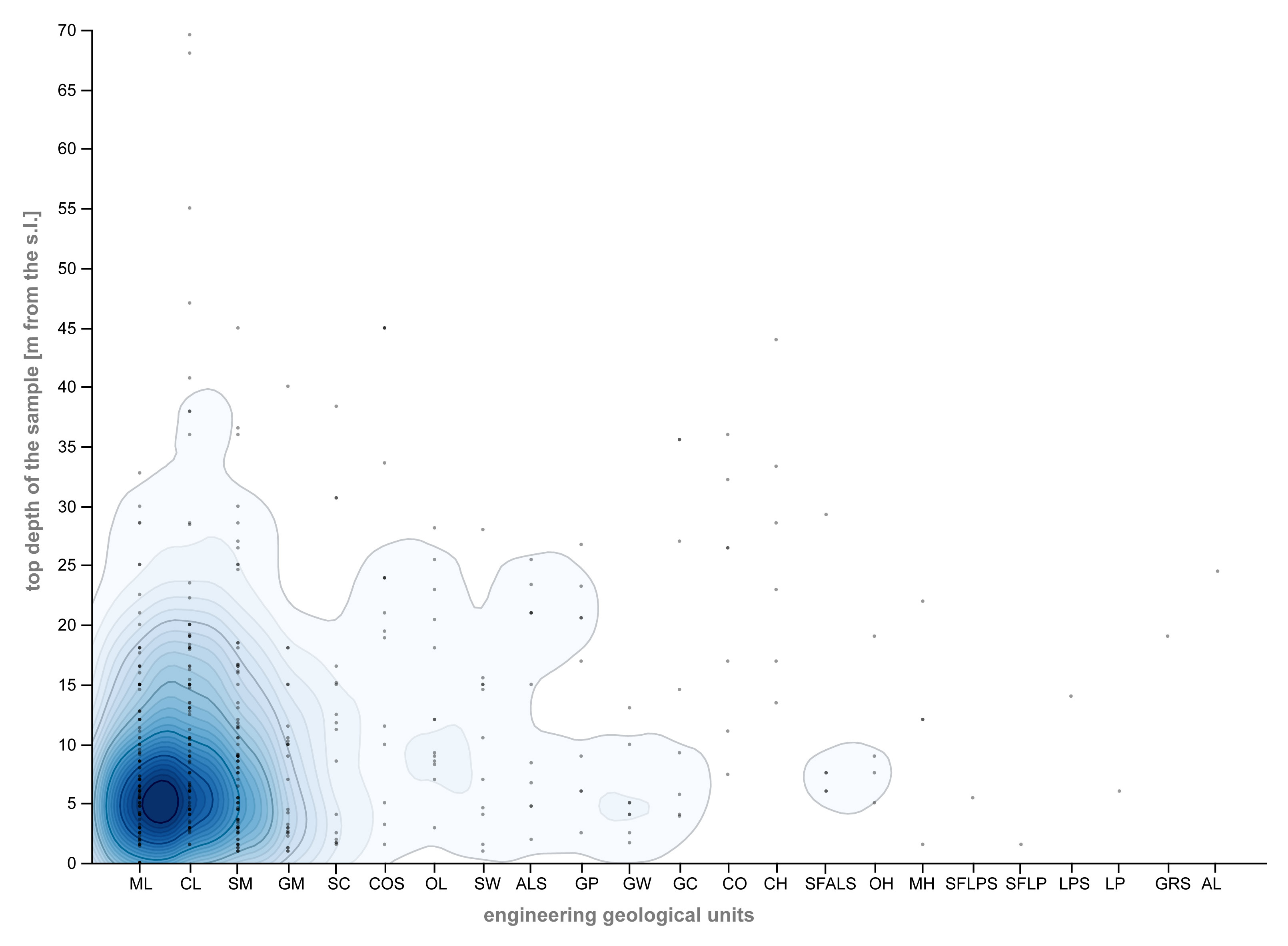
These two graphs also have the potentiality of clarifying the pitfalls of the dataset. It presents a lack of knowledge for the deepest layers: the depth of investigation of the dataset is limited to about 40 m (and to a mean confining effective pressure σ’ > 180-200 kPa). The same consideration may be done for the geological bedrock units for which a lowest number of samples are available.
Why is this approach important?
When extensive evaluations are of concern, the uncertainties of one or more parameters also play an important role. Extending results that are available for a few centimetres (i.e. the dimensions of the samples) to meters (i.e. the layer thickness) and from a few verticals (i.e. boreholes) to larger areas (i.e. cross-sections and seismically homogeneous microzones) constitutes a crucial aspect that is intrinsic to this process.
This is the rationale behind our research: it rests on the proposition that a robust harmonisation of the data available from seismic microzonation studies may support fully probabilistic seismic site-specific hazard studies. Thus, this dataset shares information suitable for mitigating geohazard risks and results in supporting the transfer of information from the laboratory scale to the scale of geological-engineering cross-sections with the goal of facilitating large-scale hazard assessments.
The engineering – geological unit link between specimen and soil type represents a key strategy since it allows the modelling of the dynamical properties of a geological body when changes of scale are applied. This scaling operation is then even more important considering that at least four sources of uncertainties may affect the numerical modelling results when using laboratory tests data as inputs: 1) loading directionality; 2) simplified schemes of application of the cyclic loading; 3) drainage conditions and 4) representativeness of samples.
The present lack of knowledge of engineering geology at a regional scale has until now limited the interpretation of the available data. These results aim to provide new insights about this topic, consequentially looking at seismic prevention at a regional scale, rather than at single municipality scale. It can be figured out, looking at the recent catastrophes, how is important study agglomerates of adjacent hamlets, since they strictly interact each other.
Follow the Topic
-
Scientific Data

A peer-reviewed, open-access journal for descriptions of datasets, and research that advances the sharing and reuse of scientific data.
Related Collections
With Collections, you can get published faster and increase your visibility.
Data for crop management
Publishing Model: Open Access
Deadline: Apr 17, 2026
Data to support drug discovery
Publishing Model: Open Access
Deadline: Apr 22, 2026
Please sign in or register for FREE
If you are a registered user on Research Communities by Springer Nature, please sign in