Home-to-school pedestrian mobility GPS data from a citizen science experiment in the Barcelona area
Published in Research Data
Understanding urban mobility has become one of the major challenges for researchers and policy makers. Motorised traffic is considered to be one of the main problems our cities face today, and cities are thus taking actions to promote sustainable mobility, walkability and pedestrian advocacy.
Thanks to the widespread availability of digital traces (e.g. mobile phone companies), much research has been done in this field. However, studies using digital traces are limited to large distance movements or origin-destination flows (typical public transportation or vehicles), and are less accurate for investigating pedestrian micro-mobility inside neighbourhoods.
There is a growing need for more accurate data to characterise pedestrians' micro-motives in relation to small-urban contexts (what makes an area more suitable for walking, how spaces are used to walk, etc.). However, micro-mobility around people’s homes is generally unavailable, and if data exists, it is generally not shareable often due to privacy issues. Citizen science and its public involvement practices in scientific research are valid options to circumvent these challenges and provide meaningful datasets for walkable cities.
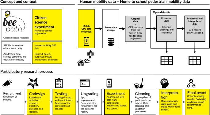
This research presents a unique and high quality pedestrian micro-mobility dataset (https://doi.org/10.34810/data523). The study shares processed GPS records from single-day home-to-school pedestrian mobility of 10 schools in the Barcelona Metropolitan area (Spain). The work is part of Beepath, a citizen science project in human mobility with the aim to introduce citizen science and participatory practices as part of education and learning activities in schools, involving both students and teachers in an activity about mobility and geolocation (http://beepath.org, in Catalan). The students also interpreted the collected data from their own school group based on their local and situated knowledge and produced data visualisations on their own. A set of evidence-based recommendations were delivered to municipal representatives to reach a wider urban perspective.
The shared dataset has gone through a rigorous filtering procedure where non-pedestrian trajectories, erroneous trajectories and outliers have been removed. A linear interpolation process has also been applied to have all GPS records uniformly spaced in time. This is much more convenient for scientific analysis on pedestrian micro-mobility. For privacy and ethical reasons, the mobility data must avoid participants identification by for instance inferring home address. A geomasking technique has therefore been applied to the processed data records to guarantee the anonymity of participants.
Apart from the urban impact of the project based on the data analysis by the students, the processed dataset represents a rich source of pedestrian micro-mobility data to study and characterise pedestrian mobility at small scales in a broader academic scientific perspective (through the statistical study of velocities, autocorrelations, reorientation processes or stochastic modelling, among some examples).
Follow the Topic
-
Scientific Data

A peer-reviewed, open-access journal for descriptions of datasets, and research that advances the sharing and reuse of scientific data.
Related Collections
With Collections, you can get published faster and increase your visibility.
Data for crop management
Publishing Model: Open Access
Deadline: Apr 17, 2026
Data to support drug discovery
Publishing Model: Open Access
Deadline: Apr 22, 2026


Please sign in or register for FREE
If you are a registered user on Research Communities by Springer Nature, please sign in