Mapping Brazil’s Human Footprint
Published in Earth & Environment, Ecology & Evolution, and Zoology & Veterinary Science

When you think of Brazil, it is easy to picture the vast expanse of the Amazon rainforest, the pristine beaches with towering dunes, and its rich biodiversity, including many non-human primate species. However, behind the idyllic idea of Brazil’s natural richness lie several questions. For example, how much of Brazil’s natural areas are still preserved and how much remains to be conserved to protect the country’s impressive biodiversity. What are the levels of human activity across the landscape? How fragmented are preserved areas?
To answer this, we’ve built the first 10-meter resolution Human Footprint Index (HFI) spatial database for all of Brazil (HIBR-10). HIBR-10 is a very detailed map of how humans are reshaping Brazil’s landscapes. But what does this reshaping mean for Brazilian wildlife?

To begin with, wildlife operates on high-resolution scales, more detailed than the global human footprint maps that typically show the human footprint at a resolution of 1 km². That’s fine if you’re studying species such as humans, or accounting for macro-level interactions, but not so useful for species that live and move within much smaller spaces.
To illustrate, let’s consider three Brazilian primate species. The bearded capuchin (Sapajus libidinosus) population on the coast of Maranhão can live within mangrove stands that are just 37 hectares in size, which is smaller than a single coarse human footprint pixel. A group of howler monkeys (Alouatta palliata) ranges over areas as small as 6 hectares. And even Brazil’s largest primate, the muriqui (Brachyteles hyposanthus), sometimes travels less than 1000 m per day. The small-bodied common marmoset (Callithrix jacchus) travels an average daily distance of 1050 m, with an estimated home range of only 7.31 hectares, or under 8 per cent of a typical HFI pixel.
With the increasing human pressure encroaching on primate groups and small populations, their conservation depends on understanding how these species interact with their environment. These big pixels blur out the details that matter. Our dataset zooms in 10,000 times closer, breaking Brazil into 86.5 billion tiny squares, each 10 m by 10 m.
HFI datasets need to transition from the spatial scale of the map creator to the spatial scale of the species of interest, as well as their scales of landscape interaction and perception. HIBR-10 is the first step in this development.
How We Built It
Creating HIBR-10 involved consolidating a range of geospatial data based on the Global Human Footprint data, which has proven effective. The significant improvement was the detailed Land cover produced by MapBiomas for the entire country. We used 136 million structures across Brazil to measure the building density for each 10 m pixel. Roads, railways, and navigable rivers from Brazilian government datasets were also incorporated into the analysis.
Each data set was reprocessed at the 10 m scale to align with MapBiomas and weighted for its influence on wildlife. For example, urban areas and densely populated building zones were weighted heavily, while railroads and navigable rivers were given lighter weights. Finally, we validated the accuracy of our spatial dataset using drone imagery at a sub-10 cm resolution and 30 cm WorldView-3 satellite data across diverse primate habitats, ranging from the Atlantic Forest to the Cerrado and mangroves.
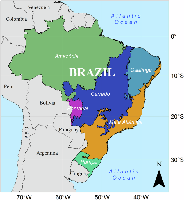
The data show that the Amazon and Pantanal biomes have large areas that are relatively pristine, but highways create expansion corridors into forests and bring associated development with them. The Cerrado and Caatinga biomes are more heavily impacted by agriculture and increasing infrastructure. Atlantic Forest coastal urbanisation leaves little intact habitat for wildlife.

Although this is a beautiful map, the critical aspect of this dataset is that it will allow conservationists to pinpoint barriers, corridors, and hotspots at the scale that animals experience them. It helps reveal where forests are too fragmented for primates to travel, where roads pose deadly risks, and where more preserved areas are smaller than they appear on coarse maps.
Data Availability
We’ve made HIBR-10 freely available for anyone to use. The full dataset, methodology, and code are available in this Zenodo Repository. The manuscript is available at Scientific Data.
Whether you’re tracking monkey movements, designing protected areas, or teaching the next generation of conservationists, this dataset opens a detailed window onto how humans are shaping nature in Brazil.
For us, mapping the human footprint isn’t just about measuring the loss of wildlife habitat; it is about identifying places where hope for their survival remains and where actions can be taken to make the biggest difference.
Follow the Topic
-
Scientific Data
A peer-reviewed, open-access journal for descriptions of datasets, and research that advances the sharing and reuse of scientific data.

Related Collections
With Collections, you can get published faster and increase your visibility.
Computer vision in plant science and agriculture
Publishing Model: Open Access
Deadline: Oct 10, 2026
Wearable and Computer Vision Data for Health and Behaviour Research
Publishing Model: Open Access
Deadline: Aug 08, 2026


Please sign in or register for FREE
If you are a registered user on Research Communities by Springer Nature, please sign in
Here is a direct link to the data
All data layers and the final data output are available in the data repository at https://doi.org/10.5281/zenodo.1530658728.
Here is the Google Earth Engine link.
https://brazil-human-footprint.projects.earthengine.app/view/brazilhumanfootprint
Here are some training videos
1 https://youtu.be/YgsWYM794Fk
2 https://youtu.be/9b3yUIRvcSM
3 https://youtu.be/x9DGCiKREOY
4 https://youtu.be/EW7_YdsZMOM
5 https://youtu.be/aDffxnGdMV4
6 https://youtu.be/Xbj7g38vy8Q
7 No Part 7
8 https://youtu.be/hzRyLvnhqgg
9 https://youtu.be/Q2tjqXivdeg
10 https://youtu.be/72VzsbH41Bg