Mediterranean forests under pressure from mega-fires on the climate-human nexus
Published in Earth & Environment and Ecology & Evolution
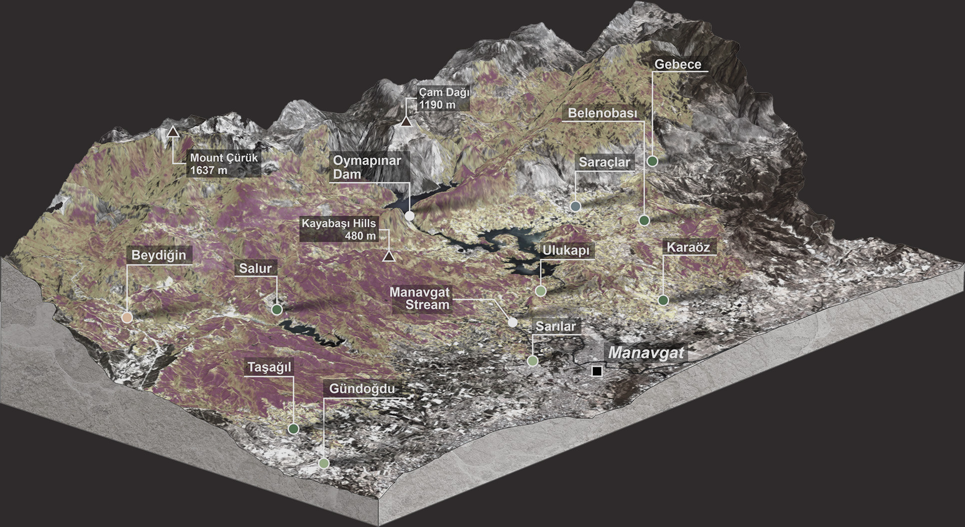
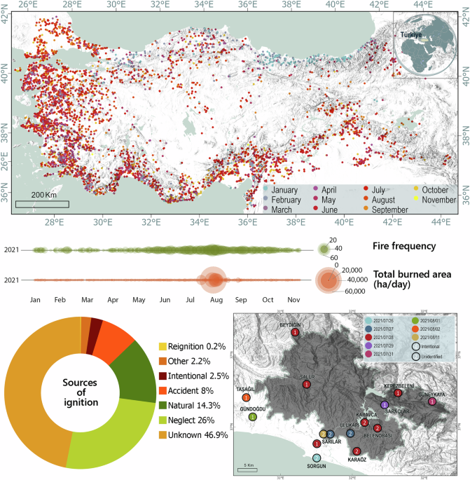
4 years ago, on July 28, a multiple ignition fire started in a pyro-catchment in Mediterranean Türkiye. With the help of strong foehn winds that were blowing the hot and dry air of the Anatolian Plateau over the Taurus Mountains, relative humidity dropping below the critical threshold and temperatures rising, the fire quickly spread. The initial ignitions were four separate cases of arson. In the following days, several other fires (different arson cases and additional ignitions whose sources were unidentified) that started in the same area would challenge suppression efforts. The wildfire, later named the Manavgat Fire, resulted in the largest burned area for this region for more than a century. Between the start (July 28) and the day when the Manavgat Fire was finally contained (August 11), 60,000 ha of forest, shrubland, human settlements and agriculture land has burned, several villages evacuated, and 8 people killed.

The multiple nuclei wildfire was in fact an incident typical of several other Mediterranean climate-type coastal settlements where wildland-human interface is a phenomenon, and where, especially during the summer months, the population and human mobility in these areas increase. The tourism season and the fire season often peak in the same months, the added human pressure increasing the already present wildfire risk. To give an example, in our analyses we found out that almost all of the unidentified ignitions were in close proximity to human settlements and roads.
With the Manavgat Fire being a prominent incident, it was a suitable candidate to study the intricate relationships along the human-climate-vegetation nexus. Thus, in this study we first delved into the climate dynamics behind the wildfire that took place in the infamous summer of 2021, during when a large part of Mediterranean Europe was also ablaze. The number of fires that were ongoing during the same period as the Manavgat Fire, not only in Türkiye but in the neighboring countries as well, put a strain on the response time and efficiency. The meteorological conditions did not help matters either. High surface wind speed not only fanned the fires but also kept the relative humidity below threshold. The foehn winds blowing hot and dry air from the Anatolian Peninsula, over the Taurus Mountain Range and into the coastal Mediterranean have always been a fire risk. However, their speed and direction on the days of the Manavgat Fire were one of the main reasons behind the fire spread.
Next, we looked at the human element. Manavgat area is a tourism hotspot, with beaches in Antalya, cool mountain air in the Taurus Mountains, a primarily karstic mountain range where underground aquifers turn into freshwater springs in places, which act as an alternative get away for those who do not favor the sun or the sea as much. The area is also an agricultural basin, with the majority of the land between the forested mountains and the coastal zone turned into a patchwork of fields, and also where green house agriculture is a popular way to grow produce in the region. The green houses are covered with easily flammable plastic sheeting and tarpaulin. The human mobility during the summer time increases, with tourists exploring the country side, daily picnickers, and villagers who migrate to their summer houses in the highlands. These transient accommodations, often deep in the forested mountain areas have over the years turned into permanent housings and lodging for the summer tourists, increasing the human traffic, and with that the number of roads that have been paved to accomodate that traffic. These roads now cut through the heart of the mountain range's forests. In case of the Manavgat Fire, most of the ignition points were along these roads, arson and non-arson alike, which led us to conclude that the wildland-urban interface played a large part in the wildfire.
Last but not least, we considered the vegetation. The northern segment of the area is a renown pyro-catchment with fire adapted maquis vegetation and the “fire-hugger” native Pinus brutia trees. However, in the higher elevations thick and pure Cedrus libani forests, as well as mixed conifer forests with Juniperus and Pinus taxa can be found. The fire strategies of all these taxa are different, and except Pinus brutia, and the maquis, all other taxa depend on seeds from the unburnt patches to reestablish their populations following a crown fire. That said, following a high precipitation year which effects the fuel load, and a dry spell which in turn makes that load flammable, surface fires can easily turn into crown fires in this geography if meteorological conditions are also conducive. And with climate change effecting the amplitudes of climatic variability, that is a high probability.
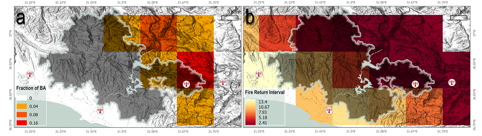
To make our case, we needed a series of non-human simulations to see the effects of climatic drivers on the vegetation. For this we used a process based dynamic vegetation model running coupled to fire modules which would provide us with fire probability, potential annual burned area, and fuel availability. We ran the model using reanalysis datasets for maximum continuity of daily climate data. Our results showed us that in the forested highlands, in this region, the burned area for that year in a human-free setting would be around four times less than what actually happened in the Manavgat Fire. For the southern segments of our study area the model assigned open woodland or shrubland, and smaller burned areas.
We have by now entered the age of megafires. And looking back at important cases, using big data and model simulations to understand the dynamics behind, and try to disentangle the complex relationships within the human-climate-vegetation nexus, can provide us with an accurate road map to prevent, and when that fails, to efficiently respond to what is to come. It is our firm belief that these analysis of the Manavgat Fire will aid future fire prevention and response efforts in this region, and other Mediterranean climate type ecosystems that share a similar fate as Manavgat.
The article:
Up in flames: the human factor behind a megafire in Mediterranean Türkiye | npj Natural Hazards
An Earth System Scientist with a PhD in Climate and Marine Sciences and a focus on terrestrial ecosystems from Eurasian Institute for Earth System Sciences at Istanbul Technical University (Avrasya Yer Bilimleri Enstitüsü). Associate Researcher at Geohazard Research Group.
Author of "Simulating the potential forest ranges in an old land: the case for Turkey’s forests" and "Latitude or altitude as the future refugium? A case for the future of forests in Asia Minor and its surroundings", her two articles that aim to predict the terrestrial ecosystem migrations under a changing climate. Avid researchers on the impacts of disturbances on (currently terrestrial) ecosystems. Wildfire modeller. Field research enthusiast. Author of "Up in Flames: the human factor behind a megafire in Mediterranean Türkiye".
For detailed information on her ongoing scientific research and outputs: https://www.researchgate.net/profile/Bikem-Ekberzade
Author of Standing Rock: Greed, Oil and Lakota's Struggle for Justice (Zed Books, 2018).
Science-policy advocate. Member of European Geosciences Union's Biodiversity Task Force, and scientific officer in the Biogeosciences Division. Also, see: Geotalk
A former photojournalist with a keen eye on under-reported conflicts/humanitarian emergencies/environmental catastrophes; a videographer eager to document the marginal/controversial/under reported issues/people/situations; a documentary producer willing to leave behind stories of ordinary people with their extra-ordinary joie de vivre/courage; an aspiring environmentalist with firsthand experience of the effects of environmental degradation on human livelihood; a long time project designer, spokesperson, advocate. For her professional work in documentary and journalism:
Follow the Topic
-
npj Natural Hazards
npj Natural Hazards considers research examining the causes and effects of natural hazards, including seismic hazards, landslides and debris flows, volcanic hazards, coastal hazards, tsunamis, tropical cyclones and hurricanes, floods, droughts, extreme weather events, avalanche hazards etc.

Related Collections
With Collections, you can get published faster and increase your visibility.
AI for Natural Hazards
Publishing Model: Open Access
Deadline: Sep 30, 2026
Weather and Climate-Induced Multi-Hazard Futures: Forecast, Communication, and Preparedness for Society
Publishing Model: Open Access
Deadline: Sep 30, 2026

Please sign in or register for FREE
If you are a registered user on Research Communities by Springer Nature, please sign in