Optimizing Farm Pond Sites for Sustainable Water Management in Drought-Prone Regions
Published in Earth & Environment, Sustainability, and Agricultural & Food Science
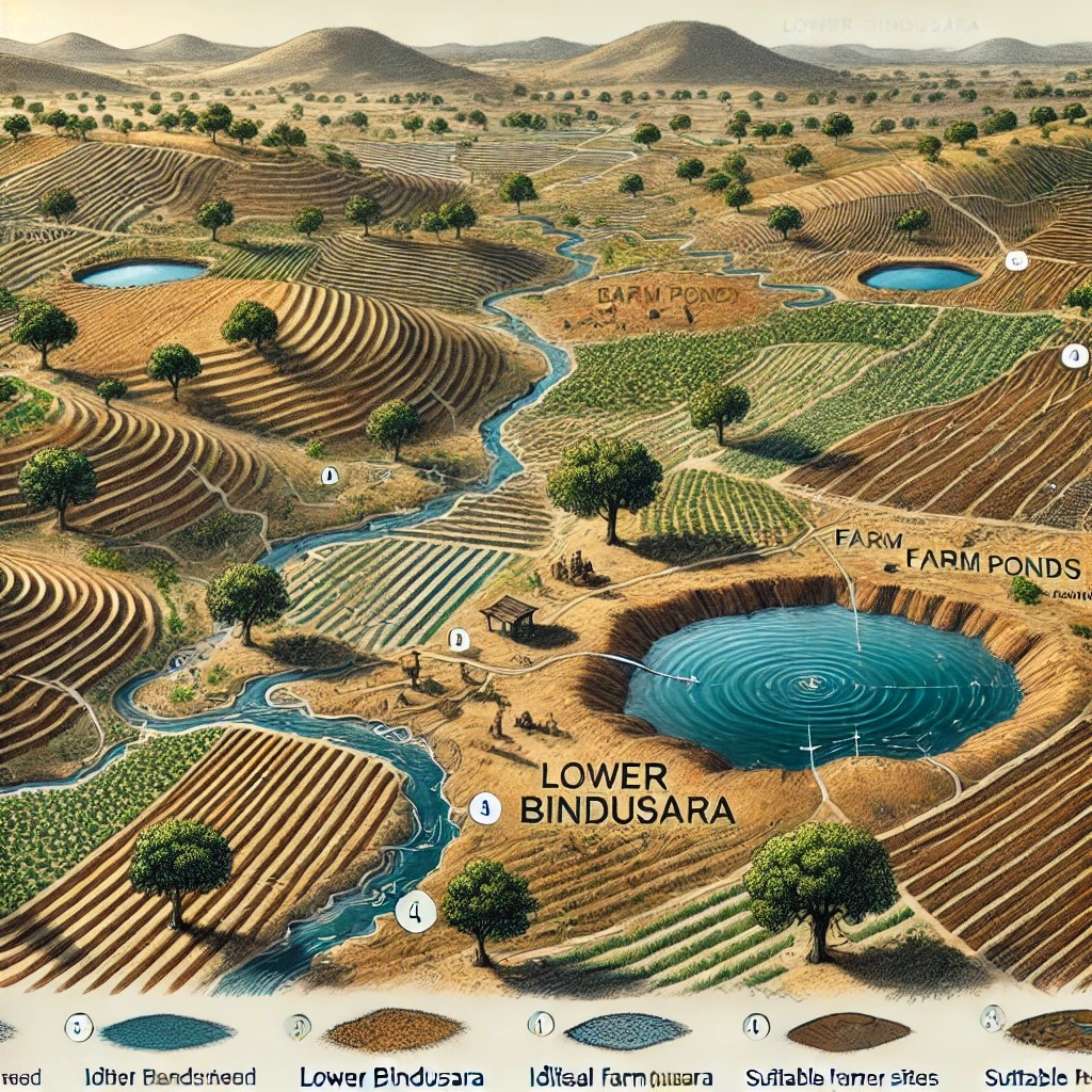


This research paper focuses on the identification of suitable sites for farm ponds in the drought-prone Lower Bindusara Watershed of Beed District, Maharashtra. Farm ponds serve as a critical water conservation measure, particularly in semi-arid regions, by capturing and storing rainwater for agricultural and domestic use. The study emphasizes the importance of sustainable water management to mitigate the challenges posed by recurring droughts and water scarcity in the region.
The study developed a Farm Pond Suitability Index (FPSI) algorithm using geospatial technologies such as Remote Sensing (RS) and Geographic Information Systems (GIS) and employed a multi-criteria analysis approach to evaluate the suitability of locations for farm ponds. Key parameters considered include Slope, Soil Depth, Soil Texture, land use/land cover, Geomorphology, Lithology, Lineament Density, Groundwater Potential Zones, drainage density, and rainfall patterns. These factors were integrated into a weighted overlay model to generate a suitability map for farm pond locations within the watershed.
The findings reveal a set of highly suitable areas for farm pond construction, offering actionable insights for policymakers, planners, and local stakeholders. By strategically implementing farm ponds in these identified areas, the region can significantly improve water retention, reduce runoff, and enhance agricultural productivity. Additionally, the study underscores the role of farm ponds in preventing land degradation, supporting sustainable livelihoods, and promoting resilience against climate variability.
This research highlights the effectiveness of geospatial tools in addressing water management challenges in drought-prone areas. It provides a replicable framework for similar studies in other regions facing water scarcity. The outcomes aim to guide future decision-making processes and contribute to long-term water security and agricultural sustainability in the Lower Bindusara Watershed and beyond.
Nideshkumar Dhawale is a research scholar specializing in Desertification and Land Degradation, currently pursuing a Ph.D. in Geography (Climatology) at Savitribai Phule Pune University. Holding an M.Tech. in Geoinformatics (2017) and an M.A. in Geography (2014), he has over ten years of experience in desertification, land degradation, climate change, and water resource management. His research interests also include geomorphic processes, remote sensing (RS) and GIS, erosion, and agricultural geography.
Nideshkumar has successfully cleared several prestigious competitive exams such as GATE-2023 in Geomatics Engineering, UGC-NET (2022) with Junior Research Fellowship eligibility, and M-SET (2022) for Assistant Professor, alongside Ph.D. entrance exams like SPPU-PET (2021), JNUEE (2020), and CUCET (2019).
Nideshkumar possesses advanced skills in software tools including ArcGIS, ERDAS Imagine, Leica Photogrammetry, QGIS, ENVI, SNAP, and GeoServer, along with programming knowledge in Python, C#, C++, and Dot NET.
Among his notable contributions is the development of the Graticule/Grid method for area measurement, which effectively addresses the challenges of accurately representing graphical scale in the digital era. He is deeply committed to exploring sustainable solutions to pressing environmental challenges through his research and expertise.
Follow the Topic
-
Journal of the Indian Society of Remote Sensing
This is a peer-reviewed international journal dedicated to advancing, disseminating, and applying knowledge in remote sensing, spatial science and photogrammetry.

What are SDG Topics?
An introduction to Sustainable Development Goals (SDGs) Topics and their role in highlighting sustainable development research.
Continue reading announcement


Please sign in or register for FREE
If you are a registered user on Research Communities by Springer Nature, please sign in