Rainfall is increasing on the edges of the South Asian Monsoon
Published in Earth & Environment
The South Asian summer monsoon is one of the most spectacular monsoon systems in the world. It affects the production and lives of billions of people. Climate change is reshaping the spatial distribution of summer monsoon rainfall. It has been reported that although the summer rainfall in the Indian subcontinent is experiencing a weakening trend, the extreme rainfall events are increasing and are aggregating into large scale events. In 2022 summer, Pakistan experienced the flood that is described as the worst flooding event in the history of this country. That underscores the need to explore the redistribution of South Asian summer rainfall under climate change.
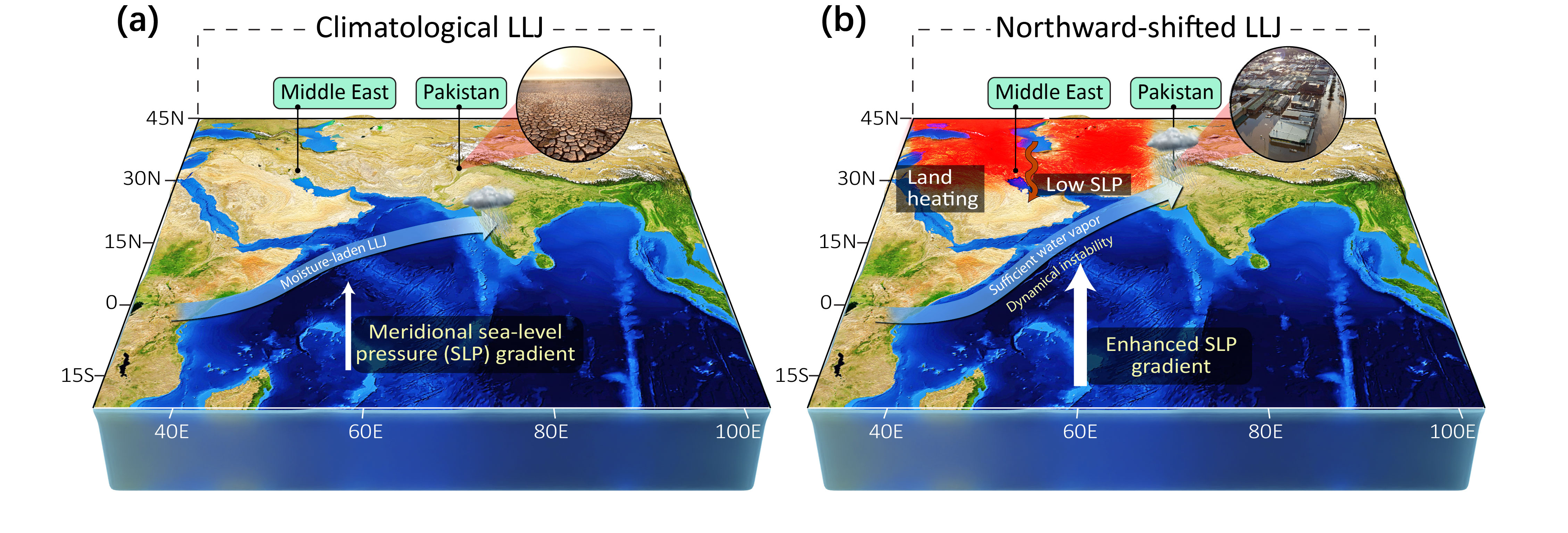
Using satellite-observed rainfall data, this study has found that rainfall over Pakistan and northwestern India during the summer monsoon has increased by 46% from 1979 to 2022 and is increasing at a rate of 0.4-0.6 mm/day per decade. This implies that arid and semi-arid countries and regions such as Pakistan and northwestern India, which are on the edge of the monsoon, are now exposed to frequent heavy rainfall events. This will lead to more disasters like the 2022 Pakistan Floods with unacceptably high loss of life and property. This finding is a red flag for these highly climate-sensitive countries and regions that are already facing a progressively increasing risk of floods.
The enhancement of summer rainfall on the edge of the South Asian monsoon is mainly caused by the rapid warming in spring over the Middle East, which leads the low-level jet (LLJ) of the South Asian summer monsoon to move northward. The LLJ is an important component of the summer monsoon, with the maximum wind speed being located at 850 hPa, with a core wind speed of 20-30 m/s. It is found that the low-level jet has been moving northward at a rate of 0.27 degrees of latitude per decade since 1979. Since LLJ transport boatloads of moisture into the subcontinent, the northward shift of the LLJ results in the excess supply of moisture to Pakistan and northwestern India. Meanwhile, the horizontal wind shear of the LLJ can generate cyclonic vorticities on its northern side, which not only causes an increase in the atmospheric instability, but also triggers the moisture convergence in the boundary layer and transport it upward, which is ultimately a critical ingredient for the occurrence of heavy rainfall.
The Middle East is one of the most significant regions in terms of global warming, which is found to be 0.5 K per decade during spring. The spring Middle East warming can trigger a decrease in sea level pressure in the region, which leads to an increase in the pressure gradient between the northern and southern hemispheres over the Indian Ocean. It can result in the enhancement of the cross-equatorial winds, which in turn leads to the emergence of LLJ-like winds in spring. This process persists until the onset of the summer monsoon, when the LLJ is further strengthens and shifts northward. The moisture supply and the instabilities complete the cascade from the cross-seasonal sea-land-air interactions to ultimately lead to increased rainfall and flood risk on the edges of the monsoon domain.

The new research provides a new insight for the spatial re-distribution of the summer monsoon. Unfortunately, the current climate models are unable to accurately depict the trend of increased rainfall on the edges of the South Asian summer monsoon. This will make it impossible to accurately project the response of these highly climate-sensitive regions to future climate change, especially at the local scales needed to guide adaptation solutions. Therefore, we need to improve the model simulations, predictions and projections for rainfall for these vulnerable regions. The need for local risk information to prepare for and reduce the impacts of these remotely forced disasters can hardly be overemphasized.
Follow the Topic
-
Nature Communications
An open access, multidisciplinary journal dedicated to publishing high-quality research in all areas of the biological, health, physical, chemical and Earth sciences.
Related Collections
With Collections, you can get published faster and increase your visibility.
Healthy Aging
Publishing Model: Open Access
Deadline: Jun 01, 2026
Women's Health
Publishing Model: Hybrid
Deadline: Ongoing


Please sign in or register for FREE
If you are a registered user on Research Communities by Springer Nature, please sign in