Rethinking urban flood resilience in the age of inequality
Published in Social Sciences, Sustainability, and Civil Engineering
This project began as a straightforward inquiry into flood protection infrastructure but evolved into something more layered. The starting point was a technical question: What are the tradeoffs between overadaptation and underadaptation in levee planning? But as discussions unfolded across our interdisciplinary team, including an economics Professor and a senior water resource professional, the focus gradually shifted. Partial protection, we came to realize, is not a neutral intervention. It has a geography, and it has consequences. Our study became an inquiry into who gains from protection, who remains exposed, and how well-meaning adaptation strategies can reshape urban risk landscapes in unequal ways.
From rivers to redistribution
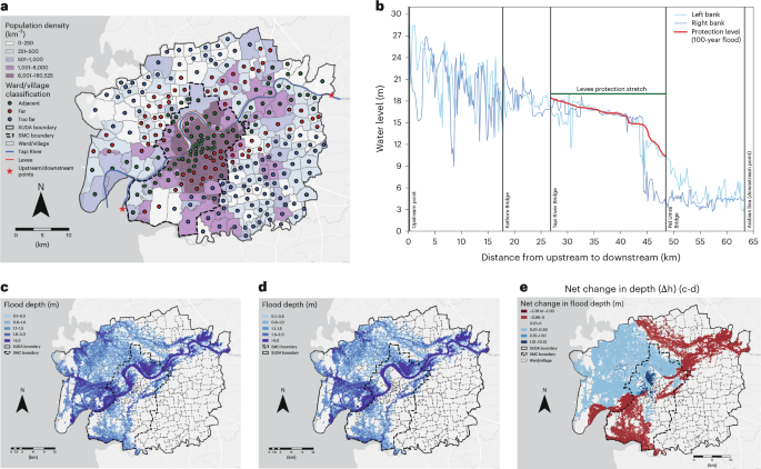
Our modeling focused on riverine flooding in a large Indian city with a typical core–periphery layout. The scenario is common across cities in the Global South. Levees are often prioritized for central or high-density areas, while peripheral zones are left unprotected due to financial or administrative constraints.
The results were unexpected.
While total flood damage reduced, the risk became more concentrated. Some neighborhoods gained up to 12 hours of lead time. Others flooded earlier than in the absence of protection, by as much as 7 hours. Many of the most adversely affected areas had higher populations of marginal workers, often used as a proxy for economic vulnerability. These results pointed to a clear redistribution of flood burden and revealed a pattern of inequity in outcomes that standard cost–benefit analysis could easily overlook.
A systems approach to urban resilience
This study was developed within the Machine Intelligence and Resilience Laboratory at IIT Gandhinagar. As principal investigator of the lab, my research centers on the intersection of climate risk, network dynamics, and decision systems for infrastructure resilience.
At MIR Lab, our framing of flood risk goes beyond hydrology or engineering performance. We view climate-linked hazards as systems problems, where applied networks, hydrodynamical models, physics-guided machine learning, data science, and policy interact. This outlook shaped both our modeling strategy and the openness to interdisciplinary questions we pursued.
The project was also conducted under the umbrella of the AI Centre of Excellence for Sustainable Cities, a national initiative supported by the Ministry of Education, Government of India, which prioritizes translational research, moving beyond theoretical advances to create frameworks and tools that can inform policy and practice. That emphasis consistently led us to ask, what value does this work offer on the ground? Can it improve real decisions?
Foundations in interdisciplinary training
This work also reflects the kind of academic ecosystem that encourages intellectual convergence. Ashish S Kumar, the study’s first author and a Prime Minister Research Fellow at IIT Gandhinagar, brought strong technical depth in hydrodynamic modeling. But what enabled this project to grow was his openness to integrate insights from economics, governance, and urban systems thinking.
In Ashish’s words, "This paper may look like a moment when everything came together, but its foundation was laid over the semesters, across coursework in advanced fluid mechanics, hydrology, hydraulics, economics, and network science, across different departments".
That environment is intentional. IIT Gandhinagar, a second-generation IIT, has been designed to support interdisciplinary collaboration across civil engineering, earth sciences, computer science, and policy.
Tools developed in response to new questions
As our inquiry matured, we realized that traditional flood maps were insufficient to answer the questions we were asking. What matters in an urban flood is not only where the water goes, but when. Lead time determines the space for action.
To capture this, we developed two complementary tools. The first, called Flood Stripes, creates a temporal visual of the non-submerged area across all neighborhoods throughout the duration of a flood event. It enables comparison of before and after adaptation scenarios across space and time.
The second tool, Protection-Induced Time Shift, quantifies how protection changes the time of onset of flooding for each neighborhood. Some areas gained critical hours of preparation time. Others lost it. Together, these tools helped us visualize flood resilience as a dynamic and distributed quantity. They also made the findings more relevant for municipal decision-making.
Implications for adaptation and equity
Urban flood adaptation often proceeds incrementally. Partial protection is a reality in many places. We do not argue against structural interventions like levees. But our findings caution against relying solely on net benefits without evaluating distributional effects.
Adaptation should not only be efficient, but it should also be fair. It should reduce overall risk without deepening existing inequities. This matters for public infrastructure agencies, urban finance departments, and disaster management planners. It is also relevant for national schemes focused on smart cities, urban missions, and resilient infrastructure corridors.
Equity cannot be an afterthought in climate adaptation. If we do not account for it explicitly, we may reinforce vulnerability while believing we are reducing it.
Where this leads
This project ends with tools, but it began with a shift in perspective. It challenged us to move from asking how much protection to asking who is protected, and at what cost.
As we expand this research to other cities and other hazards, we remain anchored in the same principle: Resilience must be citywide. Adaptation must be equitable. Floods follow the rules of physics. But their impacts follow the patterns of policy and planning. Addressing climate risk requires a language that speaks to both.
As an avid reader of Nassim Nicholas Taleb, I often find myself returning to his warning about the dangers of hindsight—our tendency to explain complex outcomes with neat stories, long after the randomness has played out. This study began almost by chance, as a routine modeling inquiry, and it is only in retrospect that it reads like a deliberate investigation into inequality and risk. In truth, we followed one question into another, and built the science as we walked. If it now feels like a coherent arc, it is because we stayed open to reframing what the problem really was. That, to me, is what makes science not always certain, but often better.
Follow the Topic
-
Nature Cities
This journal aims to deepen and integrate basic and applied understanding of the character and dynamics of cities, including their roles, impacts and influences — past, present and future.

Please sign in or register for FREE
If you are a registered user on Research Communities by Springer Nature, please sign in